
Previsioni:

Previsione a breve terminepioggia leggera (Totale 9mm), per lo più che cade Sabato mattina. Warm (Max 36°C mercoledì pomeriggio, Min 23°C Sabato mattina). Vento sarà generalmente leggero. | ||||||||||||||||||||||||
Mer 15 | Giovedì 16 | Venerdì 17 | 18 | |||||||||||||||||||||
11 AM | 2 PM | 5 PM | 8 PM | 11 PM | 2 AM | 5 AM | 8 AM | 11 AM | 2 PM | 5 PM | 8 PM | 11 PM | 2 AM | 5 AM | 8 AM | 11 AM | 2 PM | 5 PM | 8 PM | 11 PM | 2 AM | 5 AM | 8 AM | |
Mappa dell'altezza del moto ondoso |  |  |  | 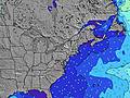 |  |  | 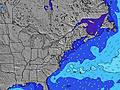 |  |  | |||||||||||||||
Onda Altezza (m) Direzione Periodo (s) | ESE 9 | ESE 9 | ESE 9 | ESE 9 | ESE 9 | S 5 | SSE 5 | SSE 5 | ESE 8 | ESE 8 | S 5 | S 4 | S 4 | S 5 | SSE 5 | SSE 5 | SSE 5 | SSE 5 | SSE 5 | SE 5 | SE 5 | SE 3 | SE 4 | SE 4 |
Grafico delle onde | ||||||||||||||||||||||||
8 | 8 | 8 | 8 | 7 | 11 | 7 | 8 | 6 | 6 | 3 | 6 | 10 | 11 | 8 | 9 | 9 | 5 | 5 | 6 | 6 | 5 | 6 | 4 | |
Vento (km/h) | ||||||||||||||||||||||||
Stato del vento onshore cross-onshore cross-shore cross-offshore offshore piatto | off | cross-off | cross-off | off | off | cross-off | on | on | glassy | cross-off | cross-off | cross-off | off | cross | cross-on | cross-on | cross-on | cross-on | cross-on | cross | cross | cross-off | glassy | on |
Alta Marea | 9:53AM1.24m | 10:17PM1.69m | 10:46AM1.28m | 11:07PM1.62m | 11:38AM1.31m | 11:57PM1.53m | ||||||||||||||||||
Basso Marea | 3:42PM-0.11m | 4:40AM-0.10m | 4:37PM-0.08m | 5:28AM-0.09m | 5:32PM-0.03m | 6:15AM-0.05m | ||||||||||||||||||
— | — | — | — | — | — | 5:48 | — | — | — | — | — | — | — | 5:48 | — | — | — | — | — | — | — | 5:48 | — | |
— | — | — | 8:23 | — | — | — | — | — | — | — | 8:23 | — | — | — | — | — | — | — | 8:22 | — | — | — | 8:22 | |
mm | — | — | — | — | — | — | — | — | — | — | — | — | — | — | — | — | — | — | — | — | — | — | — | 1 |
Temp. °C | 29 | 34 | 36 | 35 | 30 | 28 | 28 | 28 | 29 | 31 | 33 | 34 | 30 | 28 | 26 | 25 | 27 | 27 | 27 | 26 | 26 | 25 | 25 | 24 |
Gelo °C | 29 | 34 | 35 | 36 | 29 | 29 | 27 | 28 | 29 | 30 | 33 | 34 | 31 | 27 | 26 | 24 | 26 | 26 | 25 | 25 | 25 | 25 | 28 | 25 |
Onda 1 Altezza (m) Direzione Periodo (s) | SSE 4 | ESE 9 | ESE 9 | SSE 5 | ESE 9 | S 5 | SSE 5 | SSE 5 | SSE 5 | ESE 8 | S 5 | S 4 | S 4 | S 5 | SSE 5 | SSE 5 | SSE 5 | SSE 5 | SSE 5 | SE 8 | SE 8 | SE 8 | SE 8 | SE 8 |
4 | 8 | 8 | 4 | 7 | 11 | 7 | 8 | 5 | 6 | 2 | 6 | 10 | 11 | 8 | 9 | 9 | 5 | 5 | 3 | 3 | 3 | 3 | 3 | |
Onda 2 Altezza (m) Direzione Periodo (s) | ESE 9 | SSE 4 | S 4 | ESE 9 | — | ESE 8 | ESE 8 | ESE 8 | ESE 8 | — | SE 8 | SE 8 | SE 8 | SE 8 | SE 8 | SE 8 | E 4 | SE 8 | SE 8 | — | — | E 14 | E 14 | E 14 |
8 | 4 | 1 | 8 | — | 7 | 7 | 7 | 6 | — | 3 | 3 | 3 | 3 | 3 | 3 | 2 | 3 | 3 | — | — | 4 | 4 | 4 | |
Onda 3 Altezza (m) Direzione Periodo (s) | — | — | SE 5 | — | — | — | — | — | — | — | — | — | — | — | — | — | SE 8 | — | — | E 14 | E 14 | — | — | — |
— | — | 1 | — | — | — | — | — | — | — | — | — | — | — | — | — | 3 | — | — | 4 | 4 | — | — | — | |
onde vento Altezza (m) Direzione Periodo (s) | W 3 | — | — | — | S 5 | W 2 | — | — | — | SSE 5 | — | S 4 | S 5 | — | ENE 3 | ENE 3 | E 4 | E 3 | ESE 3 | SE 5 | SE 5 | SE 3 | SE 4 | SE 4 |
1 | — | — | — | 11 | 1 | — | — | — | 4 | — | 18 | 27 | — | 3 | 4 | 7 | 2 | 1 | 6 | 6 | 5 | 6 | 3 | |
Il più vicino Offshore or Glassy | ||||||||||||||||||||||||
Distanza (km) | 354 | 420 | 301 | 317 | 317 | 351 | 1029 | 1497 | 1482 | 1375 | 1375 | 258 | 26 | 62 | 317 | 1037 | 1029 | 1029 | 1040 | 2392 | 1306 | 1029 | 1029 | 1029 |
Migliori previsioni per le condizioni d'onda in Delaware | ||||||||||||||||||||||||
Migliori previsioni per le condizioni d'onda in United States | ||||||||||||||||||||||||
Trova Onde Globale | ||||||||||||||||||||||||
- Map Icons:
 Break
Break Live Wave Height (m)
 Live Wind Speed (km/h)
 Surf Rating (10 Max)
 Ocean Swells (m)
- Wind Speed (km/h)
Widget Free Surf-Forecast.com per il tuo sito
La relazione di surf / widget meteo è disponibile qui sotto per incorporare su siti esterni a titolo gratuito e fornisce una sintesi delle nostre The Cove Delaware previsione surf. Basta prendere il frammento di codice html da noi fornito e copiarlo nel proprio sito. È possibile scegliere la lingua preferita e unità metriche / imperiali per il feed delle previsioni surf per soddisfare le esigenze degli utenti del vostro sito .... Clicca qui per ottenere il codice.
 Nearest