
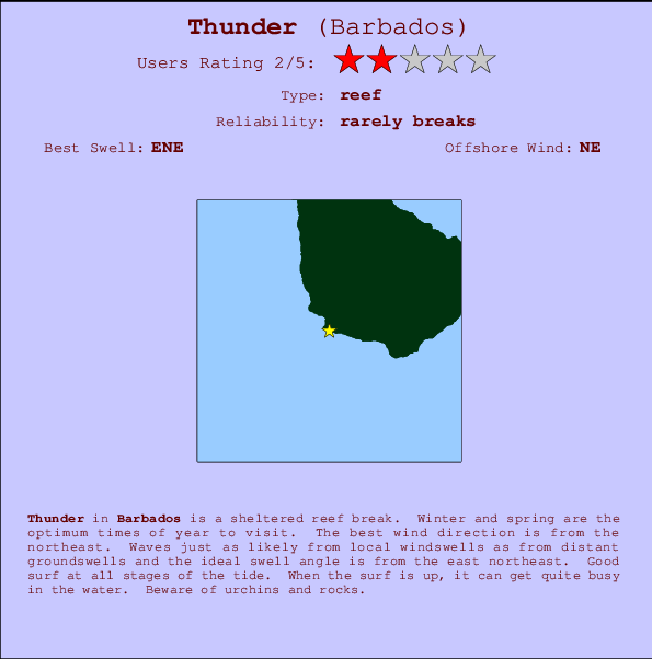
Thunder Surf Guide
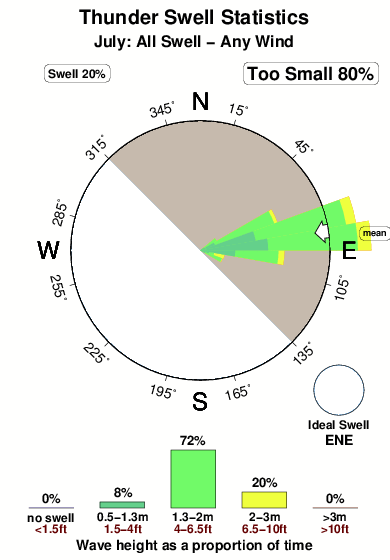
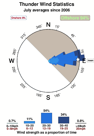
Thunder on the West Coast is a sheltered reef break. Winter and spring are the favoured times of year to visit. Offshore winds are from the northeast. Groundswells and windswells are equally likely and the ideal swell direction is from the east northeast. Reef breaks provide lefts and rights. When the surf is up, it can get quite busy in the water. Beware of urchins and rocks.
Thunder Spot Info
| Type: | Rating: | Reliability: | Todays Sea Temp*: |
|---|---|---|---|
| rarely breaks | 28.1°C*ocean temperature recorded from satellite |
Surfing Thunder:
The best conditions reported for surf at Thunder occur when a East-northeast swell combines with an offshore wind direction from the Northeast.

Previsioni Energia d'onda (Potenza): 12hrs


Thunder Surf:
Saturday, 18 July 2026, 09:23 Local time| Sabato 18 | ||||
| 5AM | 8AM | 11AM | 2PM | |
| Wave (m) | ||||
| Periodo (s) | - | - | - | - |
| Vento (km/h) | ||||
| Stato del vento | cross- off |
cross- off |
cross- off |
cross- off |
- /breaks/Thunder/forecasts/latest
Thunder Surf Guide
Thunder on the West Coast is a sheltered reef break. Winter and spring are the favoured times of year to visit. Offshore winds are from the northeast. Groundswells and windswells are equally likely and the ideal swell direction is from the east northeast. Reef breaks provide lefts and rights. When the surf is up, it can get quite busy in the water. Beware of urchins and rocks.
Thunder Spot Info
Type: Rating: Reliability: Todays Sea Temp*:  Reef
Reef 2
2rarely breaks 28.1°C*ocean temperature recorded from satelliteSurfing Thunder:
The best conditions reported for surf at Thunder occur when a East-northeast swell combines with an offshore wind direction from the Northeast.
Previsioni Energia d'onda (Potenza): 12hrs
Utilizzare la scheda di navigazione in alto per visualizzare Thunder temperatura del mare, Thunder fotografie, Thunder dettagliate previsioni onde, il vento e le previsioni meteo, Thunder webcam, vento corrente da Barbados stazioni meteo e Thunder previsioni marea. Il link Barbados mappe maree apre l'immagine grande, che mostra Barbados e dei mari circostanti. Queste mappe possono essere animate per mostrare le diverse componenti del moto ondoso, energia delle onde, periodo d'onda, altezza delle onde, insieme con le previsioni del vento e meteo, meteo corrente e osservazioni sullo stato del mare dal Barbados onda-boe, le navi passanti e stazioni meteo costiere. Ciascuna delle pagine di previsioni per questo surf break rappresenta uno strumento di wavefinder globale e regionale per individuare le migliori condizioni di surf nella zona intorno Thunder.
Thunder Surf:
Saturday, 18 July 2026, 09:23 Local timeSabato 18 5AM 8AM 11AM 2PM Wave (m) Periodo (s) - - - - Vento (km/h) Stato del vento cross-
offcross-
offcross-
offcross-
off- /breaks/Thunder/forecasts/latest
- /breaks/Thunder/forecasts/latest/six_day
Thunder Surf Guide
Thunder on the West Coast is a sheltered reef break. Winter and spring are the favoured times of year to visit. Offshore winds are from the northeast. Groundswells and windswells are equally likely and the ideal swell direction is from the east northeast. Reef breaks provide lefts and rights. When the surf is up, it can get quite busy in the water. Beware of urchins and rocks.
Thunder Spot Info
Type: Rating: Reliability: Todays Sea Temp*: Reef2rarely breaks 28.1°C*ocean temperature recorded from satelliteSurfing Thunder:
The best conditions reported for surf at Thunder occur when a East-northeast swell combines with an offshore wind direction from the Northeast.
Previsioni Energia d'onda (Potenza): 12hrs
Utilizzare la scheda di navigazione in alto per visualizzare Thunder temperatura del mare, Thunder fotografie, Thunder dettagliate previsioni onde, il vento e le previsioni meteo, Thunder webcam, vento corrente da Barbados stazioni meteo e Thunder previsioni marea. Il link Barbados mappe maree apre l'immagine grande, che mostra Barbados e dei mari circostanti. Queste mappe possono essere animate per mostrare le diverse componenti del moto ondoso, energia delle onde, periodo d'onda, altezza delle onde, insieme con le previsioni del vento e meteo, meteo corrente e osservazioni sullo stato del mare dal Barbados onda-boe, le navi passanti e stazioni meteo costiere. Ciascuna delle pagine di previsioni per questo surf break rappresenta uno strumento di wavefinder globale e regionale per individuare le migliori condizioni di surf nella zona intorno Thunder.
Thunder Surf:
Saturday, 18 July 2026, 09:23 Local timeSabato 18 5AM 8AM 11AM 2PM Wave (m) Periodo (s) - - - - Vento (km/h) Stato del vento cross-
offcross-
offcross-
offcross-
off- /breaks/Thunder/forecasts/latest
Thunder Surf Guide
Thunder on the West Coast is a sheltered reef break. Winter and spring are the favoured times of year to visit. Offshore winds are from the northeast. Groundswells and windswells are equally likely and the ideal swell direction is from the east northeast. Reef breaks provide lefts and rights. When the surf is up, it can get quite busy in the water. Beware of urchins and rocks.
Thunder Spot Info
Type: Rating: Reliability: Todays Sea Temp*: Reef2rarely breaks 28.1°C*ocean temperature recorded from satelliteSurfing Thunder:
The best conditions reported for surf at Thunder occur when a East-northeast swell combines with an offshore wind direction from the Northeast.
Previsioni Energia d'onda (Potenza): 12hrs
Utilizzare la scheda di navigazione in alto per visualizzare Thunder temperatura del mare, Thunder fotografie, Thunder dettagliate previsioni onde, il vento e le previsioni meteo, Thunder webcam, vento corrente da Barbados stazioni meteo e Thunder previsioni marea. Il link Barbados mappe maree apre l'immagine grande, che mostra Barbados e dei mari circostanti. Queste mappe possono essere animate per mostrare le diverse componenti del moto ondoso, energia delle onde, periodo d'onda, altezza delle onde, insieme con le previsioni del vento e meteo, meteo corrente e osservazioni sullo stato del mare dal Barbados onda-boe, le navi passanti e stazioni meteo costiere. Ciascuna delle pagine di previsioni per questo surf break rappresenta uno strumento di wavefinder globale e regionale per individuare le migliori condizioni di surf nella zona intorno Thunder.
Thunder Surf:
Saturday, 18 July 2026, 09:23 Local timeSabato 18 5AM 8AM 11AM 2PM Wave (m) Periodo (s) - - - - Vento (km/h) Stato del vento cross-
offcross-
offcross-
offcross-
offTide Times:
Per Bridgetown, Barbados, %{dist} %{km} da %{location}.
PROSSIMA È ALLE (ora locale) rimanente alta marea bassa marea Thunder Tide Times and Tide Chart
Live Weather:
At Grantley Adams International Airport, 13 km from Thunder.
moderate winds from the ENE
(km/h)
no reportAir temperature
27.4°COverall Thunder Surf Consistency and Wind Distribution in Luglio
foto dall' album
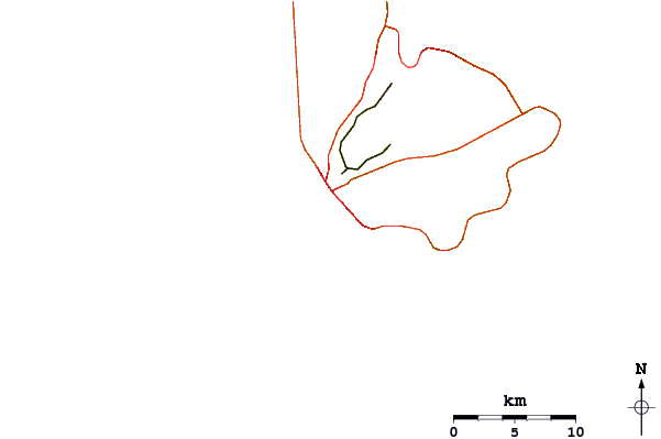
Contorni: Strade e fiumi: seleziona un surf break dal menu 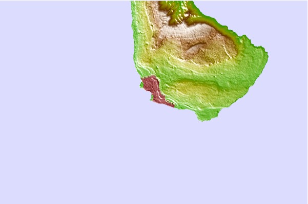
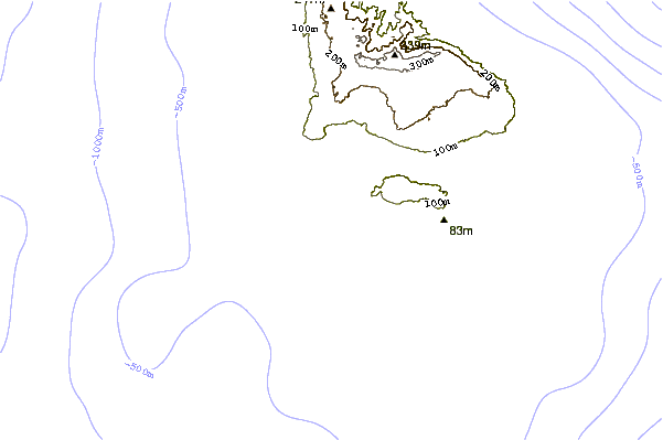
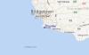
Utilizzare questa mappa sollievo per navigare Barbados surf breaks e stazioni di marea che si trovano nella zona diThunder
Altri surf breaks più vicini al Thunder:
(clicca sul nome del luogo per maggiori informazioni)- Closest località surf1 mi
- Second closest località surf1 mi
- Third closest località surf2 mi
- Fourth closest località surf2 mi
- Fifth closest località surf4 mi
Onda boe più vicina a Thunder:
- Closest Onda boa252 mi
- Second closest Onda boa352 mi
- Third closest Onda boa454 mi
- Fourth closest Onda boa495 mi
- Fifth closest Onda boa529 mi
Stazioni di marea più vicina alla Thunder:
- Closest marea stazioneBridgetown, Barbados2 mi
- Second closest marea stazioneVieux Fort Bay102 mi
- Third closest marea stazioneKingstown, Saint Vincent109 mi
- Fourth closest marea stazioneBisee112 mi
- Fifth closest marea stazionePort Castries114 mi
Airports
- The closest passenger airport to Thunder is Grantley Adams International (Bridgetown) Airport (BGI) in Barbados, 12 km (7 miles) away (directly).
- The second nearest airport to Thunder is Hewanorra International (Hewandorra) Airport (UVF) in St. Lucia Island, 163 km (101 miles) away.
- Third is Mustique Airport (MQS) in St.vincent/grenadines, 172 km (107 miles) away.
- E T Joshua (Kingstown) Airport (SVD) in St.vincent/grenadines is 174 km (108 miles) away.
- George F L Charles (Castries) Airport (SLU) in St. Lucia Island is the fifth nearest airport to Thunder and is 183 km (114 miles) away.
- /breaks/Thunder/forecasts/latest


 Nearest