
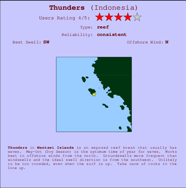
Thunders Surf Guide
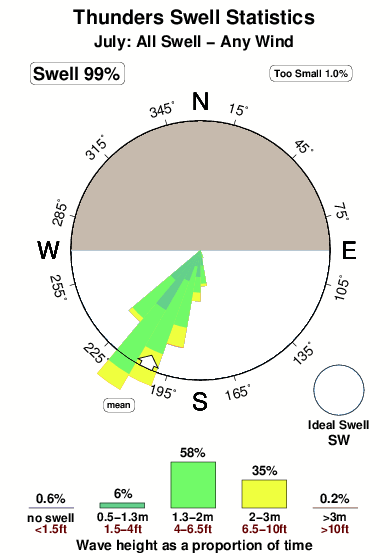
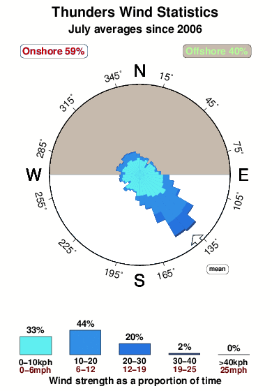
Thunders in Sumatra (Mentawi Islands) is an exposed reef break that usually has waves. May-Oct (Dry Season) is the best time of year for waves. Offshore winds are from the north. Most of the surf here comes from groundswells and the best swell direction is from the southwest. A reef breaks left. It very rarely gets crowded here. Take care of rocks in the line up.
Thunders Spot Info
| Type: | Rating: | Reliability: | Todays Sea Temp*: |
|---|---|---|---|
| consistent | 29.8°C*ocean temperature recorded from satellite |
Surfing Thunders:
The best conditions reported for surf at Thunders occur when a Southwest swell combines with an offshore wind direction from the North.

Previsioni Energia d'onda (Potenza): 12hrs


Thunders Surf:
Friday, 17 July 2026, 20:34 Local time| Venerdì 17 | ||||
| 4PM | 7PM | 10PM | 1AM | |
| Wave (m) | ||||
| Periodo (s) | 15 | 15 | 15 | 14 |
| Vento (km/h) | ||||
| Stato del vento | cross- on |
cross- on |
cross- on |
cross- on |
- /breaks/Thunders/forecasts/latest
Thunders Surf Guide
Thunders in Sumatra (Mentawi Islands) is an exposed reef break that usually has waves. May-Oct (Dry Season) is the best time of year for waves. Offshore winds are from the north. Most of the surf here comes from groundswells and the best swell direction is from the southwest. A reef breaks left. It very rarely gets crowded here. Take care of rocks in the line up.
Thunders Spot Info
Type: Rating: Reliability: Todays Sea Temp*:  Reef
Reef 4
4consistent 29.8°C*ocean temperature recorded from satelliteSurfing Thunders:
The best conditions reported for surf at Thunders occur when a Southwest swell combines with an offshore wind direction from the North.
Previsioni Energia d'onda (Potenza): 12hrs
Utilizzare la scheda di navigazione in alto per visualizzare Thunders temperatura del mare, Thunders fotografie, Thunders dettagliate previsioni onde, il vento e le previsioni meteo, Thunders webcam, vento corrente da Mentawi Islands stazioni meteo e Thunders previsioni marea. Il link Indonesia mappe maree apre l'immagine grande, che mostra Indonesia e dei mari circostanti. Queste mappe possono essere animate per mostrare le diverse componenti del moto ondoso, energia delle onde, periodo d'onda, altezza delle onde, insieme con le previsioni del vento e meteo, meteo corrente e osservazioni sullo stato del mare dal Indonesia onda-boe, le navi passanti e stazioni meteo costiere. Ciascuna delle pagine di previsioni per questo surf break rappresenta uno strumento di wavefinder globale e regionale per individuare le migliori condizioni di surf nella zona intorno Thunders.
Thunders Surf:
Friday, 17 July 2026, 20:34 Local timeVenerdì 17 4PM 7PM 10PM 1AM Wave (m) Periodo (s) 15 15 15 14 Vento (km/h) Stato del vento cross-
oncross-
oncross-
oncross-
on- /breaks/Thunders/forecasts/latest
- /breaks/Thunders/forecasts/latest/six_day
Thunders Surf Guide
Thunders in Sumatra (Mentawi Islands) is an exposed reef break that usually has waves. May-Oct (Dry Season) is the best time of year for waves. Offshore winds are from the north. Most of the surf here comes from groundswells and the best swell direction is from the southwest. A reef breaks left. It very rarely gets crowded here. Take care of rocks in the line up.
Thunders Spot Info
Type: Rating: Reliability: Todays Sea Temp*: Reef4consistent 29.8°C*ocean temperature recorded from satelliteSurfing Thunders:
The best conditions reported for surf at Thunders occur when a Southwest swell combines with an offshore wind direction from the North.
Previsioni Energia d'onda (Potenza): 12hrs
Utilizzare la scheda di navigazione in alto per visualizzare Thunders temperatura del mare, Thunders fotografie, Thunders dettagliate previsioni onde, il vento e le previsioni meteo, Thunders webcam, vento corrente da Mentawi Islands stazioni meteo e Thunders previsioni marea. Il link Indonesia mappe maree apre l'immagine grande, che mostra Indonesia e dei mari circostanti. Queste mappe possono essere animate per mostrare le diverse componenti del moto ondoso, energia delle onde, periodo d'onda, altezza delle onde, insieme con le previsioni del vento e meteo, meteo corrente e osservazioni sullo stato del mare dal Indonesia onda-boe, le navi passanti e stazioni meteo costiere. Ciascuna delle pagine di previsioni per questo surf break rappresenta uno strumento di wavefinder globale e regionale per individuare le migliori condizioni di surf nella zona intorno Thunders.
Thunders Surf:
Friday, 17 July 2026, 20:34 Local timeVenerdì 17 4PM 7PM 10PM 1AM Wave (m) Periodo (s) 15 15 15 14 Vento (km/h) Stato del vento cross-
oncross-
oncross-
oncross-
on- /breaks/Thunders/forecasts/latest
Thunders Surf Guide
Thunders in Sumatra (Mentawi Islands) is an exposed reef break that usually has waves. May-Oct (Dry Season) is the best time of year for waves. Offshore winds are from the north. Most of the surf here comes from groundswells and the best swell direction is from the southwest. A reef breaks left. It very rarely gets crowded here. Take care of rocks in the line up.
Thunders Spot Info
Type: Rating: Reliability: Todays Sea Temp*: Reef4consistent 29.8°C*ocean temperature recorded from satelliteSurfing Thunders:
The best conditions reported for surf at Thunders occur when a Southwest swell combines with an offshore wind direction from the North.
Previsioni Energia d'onda (Potenza): 12hrs
Utilizzare la scheda di navigazione in alto per visualizzare Thunders temperatura del mare, Thunders fotografie, Thunders dettagliate previsioni onde, il vento e le previsioni meteo, Thunders webcam, vento corrente da Mentawi Islands stazioni meteo e Thunders previsioni marea. Il link Indonesia mappe maree apre l'immagine grande, che mostra Indonesia e dei mari circostanti. Queste mappe possono essere animate per mostrare le diverse componenti del moto ondoso, energia delle onde, periodo d'onda, altezza delle onde, insieme con le previsioni del vento e meteo, meteo corrente e osservazioni sullo stato del mare dal Indonesia onda-boe, le navi passanti e stazioni meteo costiere. Ciascuna delle pagine di previsioni per questo surf break rappresenta uno strumento di wavefinder globale e regionale per individuare le migliori condizioni di surf nella zona intorno Thunders.
Thunders Surf:
Friday, 17 July 2026, 20:34 Local timeVenerdì 17 4PM 7PM 10PM 1AM Wave (m) Periodo (s) 15 15 15 14 Vento (km/h) Stato del vento cross-
oncross-
oncross-
oncross-
onTide Times:
Per Rags Left, %{dist} %{km} da %{location}.
PROSSIMA È ALLE (ora locale) rimanente alta marea bassa marea Thunders Tide Times and Tide Chart
Live Weather:
At Minangkabau Airport, 255 km from Thunders.
light winds from the N.(Wind varies from 320 to 030 degs)
(km/h)
Dry and partly cloudyAir temperature
26°COverall Thunders Surf Consistency and Wind Distribution in Luglio
foto dall' album
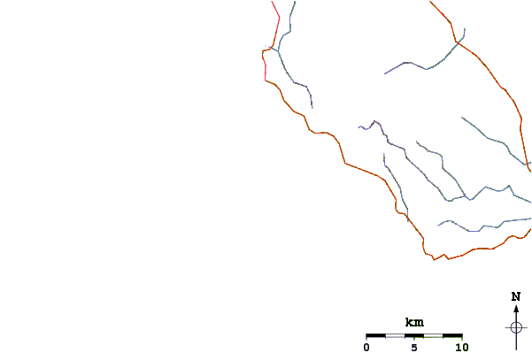
Contorni: Strade e fiumi: seleziona un surf break dal menu 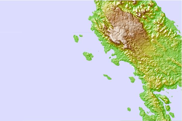
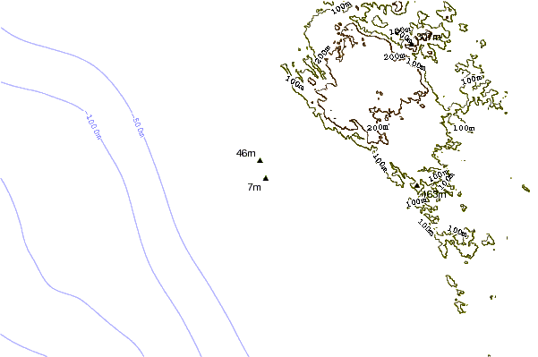
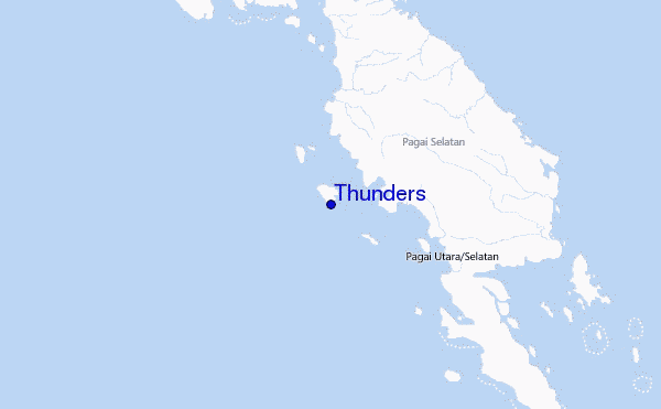
Utilizzare questa mappa sollievo per navigare Mentawi Islands surf breaks e stazioni di marea che si trovano nella zona diThunders
Altri surf breaks più vicini al Thunders:
(clicca sul nome del luogo per maggiori informazioni)- Closest località surf2 mi
- Second closest località surf6 mi
- Third closest località surf19 mi
- Fourth closest località surf20 mi
- Fifth closest località surf25 mi
Onda boe più vicina a Thunders:
- Closest Onda boa2487 mi
- Second closest Onda boa2561 mi
- Third closest Onda boa2736 mi
- Fourth closest Onda boa2750 mi
- Fifth closest Onda boa2914 mi
Stazioni di marea più vicina alla Thunders:
- Closest marea stazioneBengkulu152 mi
- Second closest marea stazionePariaman170 mi
- Third closest marea stazioneKualatungkal275 mi
- Fourth closest marea stazioneAir Musi334 mi
- Fifth closest marea stazioneSibolga347 mi
Airports
- The nearest passenger airport to Thunders is Tabing (Padang) Airport (PDG) in Indonesia, which is 246 km (153 miles) away (directly).
- The second closest airport to Thunders is Padang Kemiling (Bengkulu) Airport (BKS), also in Indonesia, 254 km (158 miles) away.
- /breaks/Thunders/forecasts/latest


 Nearest