
Previsioni:

Previsione a breve termineper lo più asciutto. Warm (Max 24°C martedì pomeriggio, Min 18°C martedì mattina). Vento sarà generalmente leggero. | ||||||||||||||||||||||||
Martedì 14 | Mercoledì 15 | Giovedì 16 | Ven 17 | |||||||||||||||||||||
5 AM | 8 AM | 11 AM | 2 PM | 5 PM | 8 PM | 11 PM | 2 AM | 5 AM | 8 AM | 11 AM | 2 PM | 5 PM | 8 PM | 11 PM | 2 AM | 5 AM | 8 AM | 11 AM | 2 PM | 5 PM | 8 PM | 11 PM | 2 AM | |
Mappa dell'altezza del moto ondoso | 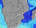 | 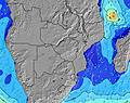 | 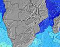 | 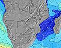 | 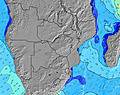 | 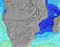 | 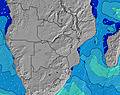 | 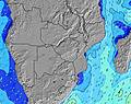 | 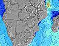 | 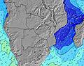 | ||||||||||||||
Onda Altezza (m) Direzione Periodo (s) | S 8 | SSE 8 | SSE 9 | SSE 9 | SSE 10 | SSE 10 | SSE 10 | SSE 10 | SSE 10 | SSE 10 | SE 10 | SE 10 | SE 10 | SE 10 | SE 10 | SE 10 | SE 10 | ESE 10 | ESE 10 | ESE 9 | SSE 8 | SSE 8 | SSE 7 | SSE 8 |
Grafico delle onde | ||||||||||||||||||||||||
177 | 190 | 254 | 248 | 622 | 565 | 810 | 778 | 576 | 622 | 587 | 625 | 499 | 738 | 667 | 557 | 546 | 320 | 246 | 231 | 223 | 244 | 208 | 191 | |
Vento (km/h) | ||||||||||||||||||||||||
Stato del vento onshore cross-onshore cross-shore cross-offshore offshore piatto | cross-off | cross-off | off | cross-off | off | off | off | cross-off | cross-off | cross-off | off | cross-off | cross-off | off | off | off | off | off | cross-off | cross-off | cross-off | cross-off | cross-off | cross-off |
Alta Marea | 3:53PM2.64m | 4:15AM2.62m | 4:36PM2.76m | 4:55AM2.69m | 5:17PM2.80m | |||||||||||||||||||
Basso Marea | 9:41AM0.27m | 10:06PM0.17m | 10:24AM0.14m | 10:48PM0.11m | 11:04AM0.07m | 11:28PM0.12m | ||||||||||||||||||
6:20 | — | — | — | — | — | — | — | 6:20 | — | — | — | — | — | — | — | 6:18 | — | — | — | — | — | — | 6:18 | |
— | — | — | — | 5:07 | — | — | — | — | — | — | — | 5:07 | — | — | — | — | — | — | — | 5:07 | — | — | 5:07 | |
mm | — | — | — | — | — | — | — | — | — | — | — | — | — | — | — | — | — | — | — | — | — | — | — | — |
Temp. °C | 18 | 18 | 23 | 24 | 23 | 21 | 20 | 19 | 19 | 20 | 24 | 24 | 23 | 22 | 22 | 22 | 21 | 22 | 23 | 23 | 23 | 23 | 22 | 22 |
Gelo °C | 17 | 16 | 21 | 21 | 19 | 18 | 18 | 17 | 16 | 17 | 21 | 21 | 20 | 20 | 21 | 21 | 19 | 19 | 19 | 19 | 19 | 20 | 20 | 21 |
Onda 1 Altezza (m) Direzione Periodo (s) | S 8 | SSE 8 | SSE 9 | SSE 9 | SSE 10 | SSE 10 | SSE 10 | SSE 10 | SSE 10 | SSE 10 | SE 10 | SE 10 | SE 10 | SSW 10 | SE 10 | SE 10 | SE 10 | ESE 10 | ESE 10 | ESE 9 | SE 9 | ESE 9 | ESE 9 | ESE 9 |
177 | 190 | 254 | 248 | 622 | 565 | 810 | 778 | 576 | 622 | 587 | 625 | 499 | 20 | 667 | 557 | 546 | 320 | 246 | 231 | 194 | 148 | 148 | 148 | |
Onda 2 Altezza (m) Direzione Periodo (s) | S 12 | S 12 | S 11 | SSE 11 | S 11 | S 11 | S 11 | S 11 | SSW 11 | SSW 11 | SSW 10 | SSW 10 | SSW 10 | SSW 10 | SSW 10 | SSW 10 | SSW 10 | SSW 10 | SSW 10 | S 11 | SSE 11 | SSE 11 | SSE 10 | SSE 10 |
144 | 96 | 123 | 161 | 93 | 63 | 62 | 61 | 39 | 38 | 37 | 21 | 20 | 20 | 20 | 10 | 10 | 10 | 10 | 10 | 11 | 11 | 11 | 20 | |
Onda 3 Altezza (m) Direzione Periodo (s) | ESE 8 | S 14 | ESE 9 | S 11 | — | — | — | — | — | — | — | — | — | — | — | — | — | S 11 | S 11 | S 10 | S 14 | S 14 | S 14 | SSW 9 |
6 | 34 | 8 | 93 | — | — | — | — | — | — | — | — | — | — | — | — | — | 2 | 3 | 7 | 4 | 4 | 4 | 8 | |
onde vento Altezza (m) Direzione Periodo (s) | — | SW 3 | — | SSW 5 | SSW 5 | S 5 | — | SSW 6 | WSW 3 | SSW 6 | — | S 6 | S 5 | SE 10 | S 6 | — | — | S 8 | SSE 8 | SSE 8 | SSE 8 | SSE 8 | SSE 7 | SSE 8 |
— | 2 | — | 32 | 42 | 64 | — | 125 | 4 | 123 | — | 62 | 57 | 738 | 61 | — | — | 161 | 197 | 202 | 223 | 244 | 208 | 191 | |
Il più vicino Offshore or Glassy | ||||||||||||||||||||||||
Distanza (km) | 0 | 1 | 0 | 9 | 804 | 0 | 0 | 1 | 1 | 1 | 0 | 1039 | 721 | 0 | 0 | 0 | 0 | 0 | 648 | 593 | 804 | 681 | 426 | 0 |
Migliori previsioni per le condizioni d'onda in Inhambane | ||||||||||||||||||||||||
Migliori previsioni per le condizioni d'onda in Mozambique | ||||||||||||||||||||||||
Trova Onde Globale | ||||||||||||||||||||||||
- Map Icons:
 Break
Break Live Wave Height (m)
 Live Wind Speed (km/h)
 Surf Rating (10 Max)
 Ocean Swells (m)
- Wind Speed (km/h)
Widget Free Surf-Forecast.com per il tuo sito
La relazione di surf / widget meteo è disponibile qui sotto per incorporare su siti esterni a titolo gratuito e fornisce una sintesi delle nostre Tofinho previsione surf. Basta prendere il frammento di codice html da noi fornito e copiarlo nel proprio sito. È possibile scegliere la lingua preferita e unità metriche / imperiali per il feed delle previsioni surf per soddisfare le esigenze degli utenti del vostro sito .... Clicca qui per ottenere il codice.
 Nearest