
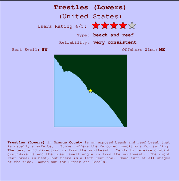
Trestles (Lowers) Surf Guide
Trestles (Lowers) in San Diego County is an exposed beach and reef break that has very reliable surf. Summer offers the favoured conditions for surfing. The best wind direction is from the northeast. Clean groundswells prevail and the ideal swell direction is from the southwest. Left and better right hand reef breaks.. The quality of the surf isn't affected by the tide. Beware of Urchin and locals.
Trestles (Lowers) Spot Info
| Type: | Rating: | Reliability: | Todays Sea Temp*: |
|---|---|---|---|
| very consistent | 20.8°C*ocean temperature recorded from satellite |
Surfing Trestles (Lowers):
The best conditions reported for surf at Trestles (Lowers) occur when a Southwest swell combines with an offshore wind direction from the Northeast.

Previsioni Energia d'onda (Potenza): 12hrs


Trestles (Lowers) Surf:
Monday, 13 July 2026, 23:36 Local time| Lun | Mar | |||
| 8PM | 11PM | 2AM | 5AM | |
| Wave (m) | ||||
| Periodo (s) | 14 | 14 | 14 | 14 |
| Vento (km/h) | ||||
| Stato del vento | cross- on |
glass | glass | cross |
- /breaks/Trestles_Lowers/forecasts/latest
Trestles (Lowers) Surf Guide
Trestles (Lowers) in San Diego County is an exposed beach and reef break that has very reliable surf. Summer offers the favoured conditions for surfing. The best wind direction is from the northeast. Clean groundswells prevail and the ideal swell direction is from the southwest. Left and better right hand reef breaks.. The quality of the surf isn't affected by the tide. Beware of Urchin and locals.
Trestles (Lowers) Spot Info
Type: Rating: Reliability: Todays Sea Temp*:  Beach and reef
 4
4very consistent 20.8°C*ocean temperature recorded from satelliteSurfing Trestles (Lowers):
The best conditions reported for surf at Trestles (Lowers) occur when a Southwest swell combines with an offshore wind direction from the Northeast.
Previsioni Energia d'onda (Potenza): 12hrs
Utilizzare la scheda di navigazione in alto per visualizzare Trestles (Lowers) temperatura del mare, Trestles (Lowers) fotografie, Trestles (Lowers) dettagliate previsioni onde, il vento e le previsioni meteo, Trestles (Lowers) webcam, vento corrente da CAL - Orange County stazioni meteo e Trestles (Lowers) previsioni marea. Il link United States mappe maree apre l'immagine grande, che mostra United States e dei mari circostanti. Queste mappe possono essere animate per mostrare le diverse componenti del moto ondoso, energia delle onde, periodo d'onda, altezza delle onde, insieme con le previsioni del vento e meteo, meteo corrente e osservazioni sullo stato del mare dal United States onda-boe, le navi passanti e stazioni meteo costiere. Ciascuna delle pagine di previsioni per questo surf break rappresenta uno strumento di wavefinder globale e regionale per individuare le migliori condizioni di surf nella zona intorno Trestles (Lowers).
Trestles (Lowers) Surf:
Monday, 13 July 2026, 23:36 Local timeLun Mar 8PM 11PM 2AM 5AM Wave (m) Periodo (s) 14 14 14 14 Vento (km/h) Stato del vento cross-
onglass glass cross - /breaks/Trestles_Lowers/forecasts/latest
- /breaks/Trestles_Lowers/forecasts/latest/six_day
Trestles (Lowers) Surf Guide
Trestles (Lowers) in San Diego County is an exposed beach and reef break that has very reliable surf. Summer offers the favoured conditions for surfing. The best wind direction is from the northeast. Clean groundswells prevail and the ideal swell direction is from the southwest. Left and better right hand reef breaks.. The quality of the surf isn't affected by the tide. Beware of Urchin and locals.
Trestles (Lowers) Spot Info
Type: Rating: Reliability: Todays Sea Temp*: Beach and reef4very consistent 20.8°C*ocean temperature recorded from satelliteSurfing Trestles (Lowers):
The best conditions reported for surf at Trestles (Lowers) occur when a Southwest swell combines with an offshore wind direction from the Northeast.
Previsioni Energia d'onda (Potenza): 12hrs
Utilizzare la scheda di navigazione in alto per visualizzare Trestles (Lowers) temperatura del mare, Trestles (Lowers) fotografie, Trestles (Lowers) dettagliate previsioni onde, il vento e le previsioni meteo, Trestles (Lowers) webcam, vento corrente da CAL - Orange County stazioni meteo e Trestles (Lowers) previsioni marea. Il link United States mappe maree apre l'immagine grande, che mostra United States e dei mari circostanti. Queste mappe possono essere animate per mostrare le diverse componenti del moto ondoso, energia delle onde, periodo d'onda, altezza delle onde, insieme con le previsioni del vento e meteo, meteo corrente e osservazioni sullo stato del mare dal United States onda-boe, le navi passanti e stazioni meteo costiere. Ciascuna delle pagine di previsioni per questo surf break rappresenta uno strumento di wavefinder globale e regionale per individuare le migliori condizioni di surf nella zona intorno Trestles (Lowers).
Trestles (Lowers) Surf:
Monday, 13 July 2026, 23:36 Local timeLun Mar 8PM 11PM 2AM 5AM Wave (m) Periodo (s) 14 14 14 14 Vento (km/h) Stato del vento cross-
onglass glass cross - /breaks/Trestles_Lowers/forecasts/latest
Trestles (Lowers) Surf Guide
Trestles (Lowers) in San Diego County is an exposed beach and reef break that has very reliable surf. Summer offers the favoured conditions for surfing. The best wind direction is from the northeast. Clean groundswells prevail and the ideal swell direction is from the southwest. Left and better right hand reef breaks.. The quality of the surf isn't affected by the tide. Beware of Urchin and locals.
Trestles (Lowers) Spot Info
Type: Rating: Reliability: Todays Sea Temp*: Beach and reef4very consistent 20.8°C*ocean temperature recorded from satelliteSurfing Trestles (Lowers):
The best conditions reported for surf at Trestles (Lowers) occur when a Southwest swell combines with an offshore wind direction from the Northeast.
Previsioni Energia d'onda (Potenza): 12hrs
Utilizzare la scheda di navigazione in alto per visualizzare Trestles (Lowers) temperatura del mare, Trestles (Lowers) fotografie, Trestles (Lowers) dettagliate previsioni onde, il vento e le previsioni meteo, Trestles (Lowers) webcam, vento corrente da CAL - Orange County stazioni meteo e Trestles (Lowers) previsioni marea. Il link United States mappe maree apre l'immagine grande, che mostra United States e dei mari circostanti. Queste mappe possono essere animate per mostrare le diverse componenti del moto ondoso, energia delle onde, periodo d'onda, altezza delle onde, insieme con le previsioni del vento e meteo, meteo corrente e osservazioni sullo stato del mare dal United States onda-boe, le navi passanti e stazioni meteo costiere. Ciascuna delle pagine di previsioni per questo surf break rappresenta uno strumento di wavefinder globale e regionale per individuare le migliori condizioni di surf nella zona intorno Trestles (Lowers).
Trestles (Lowers) Surf:
Monday, 13 July 2026, 23:36 Local timeLun Mar 8PM 11PM 2AM 5AM Wave (m) Periodo (s) 14 14 14 14 Vento (km/h) Stato del vento cross-
onglass glass cross Tide Times:
Per San Clemente, California, %{dist} %{km} da %{location}.
PROSSIMA È ALLE (ora locale) rimanente alta marea bassa marea Trestles (Lowers) Tide Times and Tide Chart
Live Weather:
At BUOY-46277, 8 km from Trestles (Lowers).
- Air temperature
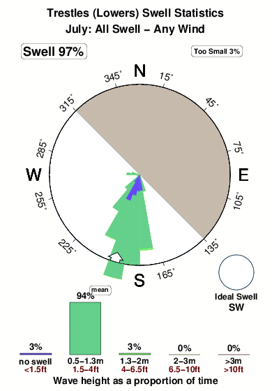
19.9°COverall Trestles (Lowers) Surf Consistency and Wind Distribution in Luglio
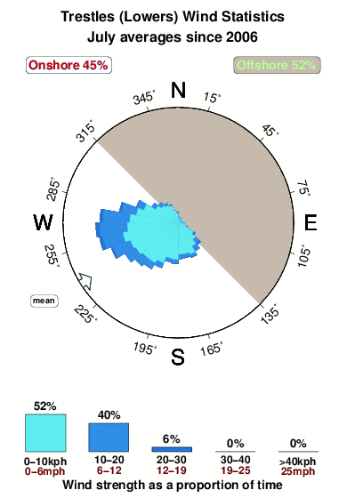


Wind stats for Trestles (Lowers): see the variation in direction and stength by month.
foto dall' album
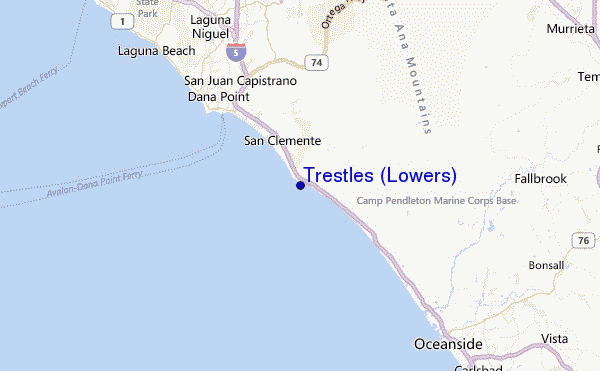
Contorni: Strade e fiumi: seleziona un surf break dal menu 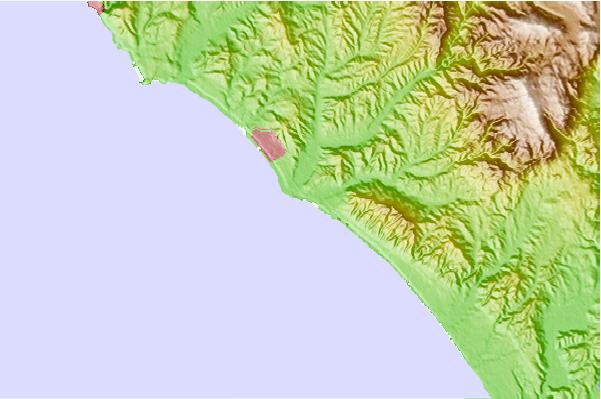
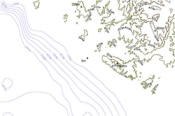
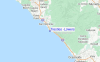
Utilizzare questa mappa sollievo per navigare CAL - Orange County surf breaks e stazioni di marea che si trovano nella zona diTrestles (Lowers)
Altri surf breaks più vicini al Trestles (Lowers):
(clicca sul nome del luogo per maggiori informazioni)- Closest località surf1 mi
- Second closest località surf1 mi
- Third closest località surf1 mi
- Fourth closest località surf2 mi
- Fifth closest località surf2 mi
Onda boe più vicina a Trestles (Lowers):
- Closest Onda boa14 mi
- Second closest Onda boa16 mi
- Third closest Onda boa33 mi
- Fourth closest Onda boa37 mi
- Fifth closest Onda boa40 mi
Stazioni di marea più vicina alla Trestles (Lowers):
- Closest marea stazioneSan Clemente3 mi
- Second closest marea stazioneDana Point9 mi
- Third closest marea stazioneLaguna Niguel12 mi
- Fourth closest marea stazioneLaguna Beach16 mi
- Fifth closest marea stazioneOceanside17 mi
Airports
- The closest passenger airport to Trestles (Lowers) is John Wayne Arpt Orange Co (Santa Ana) Airport (SNA) in USA, 42 km (26 miles) away (directly).
- The second nearest airport to Trestles (Lowers) is Tustin Mcaf Airport (NTK), also in USA, 43 km (27 miles) away.
- Third is March Arb (Riverside) Airport (RIV) in USA, 63 km (39 miles) away.
- Riverside Muni Airport (RAL) in USA is 65 km (40 miles) away.
- Miramar Mcas Airport (NKX), also in USA is the fifth nearest airport to Trestles (Lowers) and is 70 km (43 miles) away.
- /breaks/Trestles_Lowers/forecasts/latest
 Nearest