

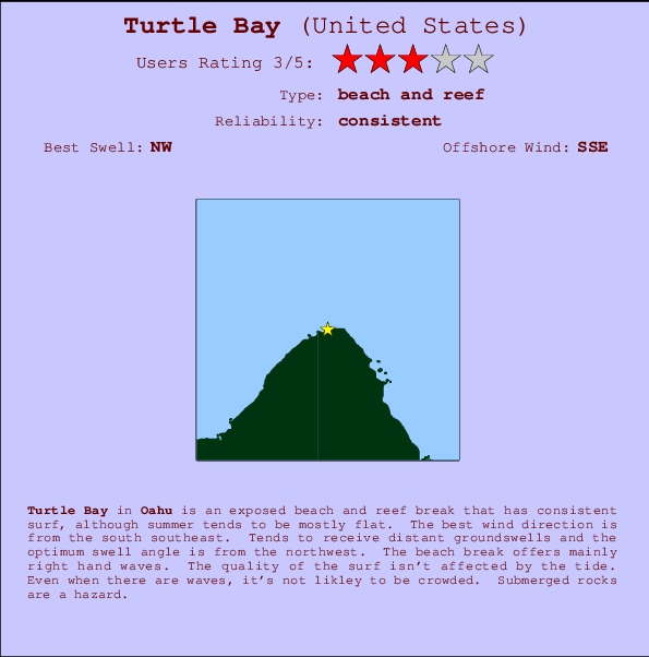
Turtle Bay Surf Guide
Turtle Bay in Oahu is an exposed beach and reef break that has consistent surf, although summer tends to be mostly flat. Works best in offshore winds from the south southeast. Tends to receive distant groundswells and the ideal swell direction is from the northwest. The beach break favours right handers. The quality of the surf isn't affected by the tide. Even when there are waves, it's not likley to be crowded. Watch out for rocks.
Turtle Bay Spot Info
| Type: | Rating: | Reliability: | Todays Sea Temp*: |
|---|---|---|---|
| consistent | 26.0°C*ocean temperature recorded from satellite |
Surfing Turtle Bay:
The best conditions reported for surf at Turtle Bay occur when a Northwest swell combines with an offshore wind direction from the South-southeast.
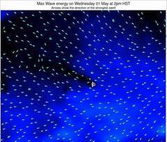
Previsioni Energia d'onda (Potenza): 12hrs

Turtle Bay Surf:
Friday, 17 July 2026, 08:41 Local time| Venerdì 17 | ||||
| 5AM | 8AM | 11AM | 2PM | |
| Wave (m) | ||||
| Periodo (s) | 14 | 14 | 14 | 14 |
| Vento (km/h) | ||||
| Stato del vento | cross- off |
cross- off |
cross- off |
cross- off |
- /breaks/Turtle-Bay/forecasts/latest
Turtle Bay Surf Guide
Turtle Bay in Oahu is an exposed beach and reef break that has consistent surf, although summer tends to be mostly flat. Works best in offshore winds from the south southeast. Tends to receive distant groundswells and the ideal swell direction is from the northwest. The beach break favours right handers. The quality of the surf isn't affected by the tide. Even when there are waves, it's not likley to be crowded. Watch out for rocks.
Turtle Bay Spot Info
Type: Rating: Reliability: Todays Sea Temp*:  Beach and reef
 3
3consistent 26.0°C*ocean temperature recorded from satelliteSurfing Turtle Bay:
The best conditions reported for surf at Turtle Bay occur when a Northwest swell combines with an offshore wind direction from the South-southeast.
Previsioni Energia d'onda (Potenza): 12hrs
Utilizzare la scheda di navigazione in alto per visualizzare Turtle Bay temperatura del mare, Turtle Bay fotografie, Turtle Bay dettagliate previsioni onde, il vento e le previsioni meteo, Turtle Bay webcam, vento corrente da HAW - Oahu stazioni meteo e Turtle Bay previsioni marea. Il link United States mappe maree apre l'immagine grande, che mostra United States e dei mari circostanti. Queste mappe possono essere animate per mostrare le diverse componenti del moto ondoso, energia delle onde, periodo d'onda, altezza delle onde, insieme con le previsioni del vento e meteo, meteo corrente e osservazioni sullo stato del mare dal United States onda-boe, le navi passanti e stazioni meteo costiere. Ciascuna delle pagine di previsioni per questo surf break rappresenta uno strumento di wavefinder globale e regionale per individuare le migliori condizioni di surf nella zona intorno Turtle Bay.
Turtle Bay Surf:
Friday, 17 July 2026, 08:41 Local timeVenerdì 17 5AM 8AM 11AM 2PM Wave (m) Periodo (s) 14 14 14 14 Vento (km/h) Stato del vento cross-
offcross-
offcross-
offcross-
off- /breaks/Turtle-Bay/forecasts/latest
- /breaks/Turtle-Bay/forecasts/latest/six_day
Turtle Bay Surf Guide
Turtle Bay in Oahu is an exposed beach and reef break that has consistent surf, although summer tends to be mostly flat. Works best in offshore winds from the south southeast. Tends to receive distant groundswells and the ideal swell direction is from the northwest. The beach break favours right handers. The quality of the surf isn't affected by the tide. Even when there are waves, it's not likley to be crowded. Watch out for rocks.
Turtle Bay Spot Info
Type: Rating: Reliability: Todays Sea Temp*: Beach and reef3consistent 26.0°C*ocean temperature recorded from satelliteSurfing Turtle Bay:
The best conditions reported for surf at Turtle Bay occur when a Northwest swell combines with an offshore wind direction from the South-southeast.
Previsioni Energia d'onda (Potenza): 12hrs
Utilizzare la scheda di navigazione in alto per visualizzare Turtle Bay temperatura del mare, Turtle Bay fotografie, Turtle Bay dettagliate previsioni onde, il vento e le previsioni meteo, Turtle Bay webcam, vento corrente da HAW - Oahu stazioni meteo e Turtle Bay previsioni marea. Il link United States mappe maree apre l'immagine grande, che mostra United States e dei mari circostanti. Queste mappe possono essere animate per mostrare le diverse componenti del moto ondoso, energia delle onde, periodo d'onda, altezza delle onde, insieme con le previsioni del vento e meteo, meteo corrente e osservazioni sullo stato del mare dal United States onda-boe, le navi passanti e stazioni meteo costiere. Ciascuna delle pagine di previsioni per questo surf break rappresenta uno strumento di wavefinder globale e regionale per individuare le migliori condizioni di surf nella zona intorno Turtle Bay.
Turtle Bay Surf:
Friday, 17 July 2026, 08:41 Local timeVenerdì 17 5AM 8AM 11AM 2PM Wave (m) Periodo (s) 14 14 14 14 Vento (km/h) Stato del vento cross-
offcross-
offcross-
offcross-
off- /breaks/Turtle-Bay/forecasts/latest
Turtle Bay Surf Guide
Turtle Bay in Oahu is an exposed beach and reef break that has consistent surf, although summer tends to be mostly flat. Works best in offshore winds from the south southeast. Tends to receive distant groundswells and the ideal swell direction is from the northwest. The beach break favours right handers. The quality of the surf isn't affected by the tide. Even when there are waves, it's not likley to be crowded. Watch out for rocks.
Turtle Bay Spot Info
Type: Rating: Reliability: Todays Sea Temp*: Beach and reef3consistent 26.0°C*ocean temperature recorded from satelliteSurfing Turtle Bay:
The best conditions reported for surf at Turtle Bay occur when a Northwest swell combines with an offshore wind direction from the South-southeast.
Previsioni Energia d'onda (Potenza): 12hrs
Utilizzare la scheda di navigazione in alto per visualizzare Turtle Bay temperatura del mare, Turtle Bay fotografie, Turtle Bay dettagliate previsioni onde, il vento e le previsioni meteo, Turtle Bay webcam, vento corrente da HAW - Oahu stazioni meteo e Turtle Bay previsioni marea. Il link United States mappe maree apre l'immagine grande, che mostra United States e dei mari circostanti. Queste mappe possono essere animate per mostrare le diverse componenti del moto ondoso, energia delle onde, periodo d'onda, altezza delle onde, insieme con le previsioni del vento e meteo, meteo corrente e osservazioni sullo stato del mare dal United States onda-boe, le navi passanti e stazioni meteo costiere. Ciascuna delle pagine di previsioni per questo surf break rappresenta uno strumento di wavefinder globale e regionale per individuare le migliori condizioni di surf nella zona intorno Turtle Bay.
Turtle Bay Surf:
Friday, 17 July 2026, 08:41 Local timeVenerdì 17 5AM 8AM 11AM 2PM Wave (m) Periodo (s) 14 14 14 14 Vento (km/h) Stato del vento cross-
offcross-
offcross-
offcross-
offTide Times:
Per Backyards, %{dist} %{km} da %{location}.
PROSSIMA È ALLE (ora locale) rimanente alta marea bassa marea Turtle Bay Tide Times and Tide Chart
Live Weather:
At Waimea Bay- HI, 14 km from Turtle Bay.
- Air temperature
-°CCurrent weather near Turtle Bay
Buoy Data:
At Waimea Bay, HI, 9 miles from Turtle Bay.
4AM 5AM 6AM 7AM Attualità dei dati 4 hr 3 hr 2 hr 1 hr Altezza delle onde (m) 

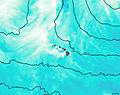
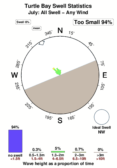
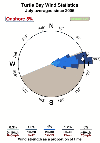
Periodo dominante (s) 7 8 8 8 Overall Turtle Bay Surf Consistency and Wind Distribution in Luglio
foto dall' album
Contorni: Strade e fiumi: seleziona un surf break dal menu 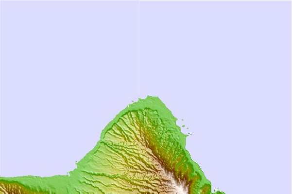
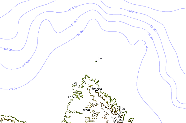
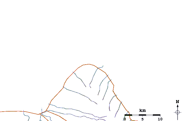
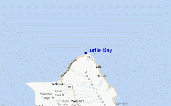
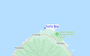
Utilizzare questa mappa sollievo per navigare HAW - Oahu surf breaks e stazioni di marea che si trovano nella zona diTurtle Bay
Altri surf breaks più vicini al Turtle Bay:
(clicca sul nome del luogo per maggiori informazioni)- Closest località surf0 mi
- Second closest località surf2 mi
- Third closest località surf3 mi
- Fourth closest località surf3 mi
- Fifth closest località surf3 mi
Onda boe più vicina a Turtle Bay:
- Closest Onda boa9 mi
- Second closest Onda boa22 mi
- Third closest Onda boa22 mi
- Fourth closest Onda boa28 mi
- Fifth closest Onda boa29 mi
Stazioni di marea più vicina alla Turtle Bay:
- Closest marea stazioneLaie Bay, Oahu Island6 mi
- Second closest marea stazioneHaleiwa, Waialua Bay, Oahu Island11 mi
- Third closest marea stazioneWaikane, Kaneohe Bay, Oahu Island17 mi
- Fourth closest marea stazioneMoku o Loe, Kaneohe Bay Oahu Island19 mi
- Fifth closest marea stazioneWaipi'o21 mi
Airports
- The closest passenger airport to Turtle Bay is Dillingham Airport (HDH) in Usa Oahu Isl., 27 km (17 miles) away (directly).
- The second nearest airport to Turtle Bay is Kaneohe Bay Mcaf Airport (NGF), also in Usa Oahu Isl., 37 km (23 miles) away.
- Third is Honolulu International Airport (HNL) in Usa Oahu Isl., 44 km (27 miles) away.
- Molokai Airport (MKK) in Usa Molokai Isl. is 111 km (69 miles) away.
- Lihue Airport (LIH) in Usa Kauai Isl. is the fifth nearest airport to Turtle Bay and is 143 km (89 miles) away.
- /breaks/Turtle-Bay/forecasts/latest


 Nearest