
Previsioni:

Previsione a breve termineper lo più asciutto. Very mild (Max 15°C Venerdì mattina, Min 12°C Sabato notte). Vento sarà generalmente leggero. | ||||||||||||||||||||||||
Venerdì 17 | Sabato 18 | Domenica 19 | ||||||||||||||||||||||
2 AM | 5 AM | 8 AM | 11 AM | 2 PM | 5 PM | 8 PM | 11 PM | 2 AM | 5 AM | 8 AM | 11 AM | 2 PM | 5 PM | 8 PM | 11 PM | 2 AM | 5 AM | 8 AM | 11 AM | 2 PM | 5 PM | 8 PM | 11 PM | |
Mappa dell'altezza del moto ondoso |  | 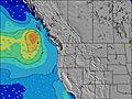 | 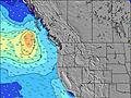 | 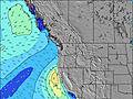 | 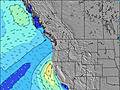 | 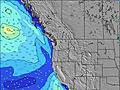 | 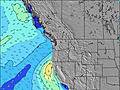 | 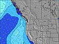 | 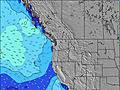 | |||||||||||||||
Onda Altezza (m) Direzione Periodo (s) | W 17 | WNW 17 | WNW 17 | WNW 16 | WNW 16 | WNW 16 | WNW 16 | WNW 16 | WNW 16 | WNW 16 | WNW 16 | W 16 | WNW 16 | WNW 16 | W 15 | SW 17 | SW 18 | SW 18 | SW 18 | W 14 | W 14 | W 14 | W 14 | SW 16 |
Grafico delle onde | ||||||||||||||||||||||||
368 | 390 | 385 | 359 | 346 | 266 | 266 | 341 | 337 | 333 | 329 | 239 | 250 | 250 | 243 | 309 | 252 | 260 | 168 | 150 | 150 | 148 | 148 | 161 | |
Vento (km/h) | ||||||||||||||||||||||||
Stato del vento onshore cross-onshore cross-shore cross-offshore offshore piatto | cross-on | cross | cross-on | on | on | cross-on | cross-on | cross | cross-off | glassy | cross-off | cross | cross | cross-off | cross-off | cross-off | cross-off | cross-off | cross-off | cross-off | cross | cross-off | cross-off | cross-off |
Alta Marea | 3:08AM2.58m | 4:25PM2.37m | 4:01AM2.38m | 5:05PM2.41m | 4:55AM2.16m | 5:44PM2.42m | ||||||||||||||||||
Basso Marea | 9:34AM-0.48m | 9:50PM0.59m | 10:13AM-0.24m | 10:44PM0.52m | 10:52AM0.05m | |||||||||||||||||||
— | 5:39 | — | — | — | — | — | — | — | 5:41 | — | — | — | — | — | — | — | 5:41 | — | — | — | — | — | — | |
— | — | — | — | — | — | 9:02 | — | — | — | — | — | — | — | 9:01 | — | — | — | — | — | — | — | 9:00 | — | |
mm | — | — | — | — | — | — | — | — | — | — | — | — | — | — | — | — | — | — | — | — | — | — | — | — |
Temp. °C | 15 | 14 | 14 | 15 | 15 | 15 | 15 | 14 | 14 | 14 | 13 | 14 | 14 | 14 | 13 | 12 | 12 | 12 | 12 | 13 | 13 | 14 | 14 | 13 |
Gelo °C | 13 | 12 | 12 | 13 | 12 | 13 | 14 | 13 | 14 | 14 | 12 | 13 | 11 | 10 | 10 | 10 | 10 | 10 | 10 | 10 | 10 | 11 | 11 | 11 |
Onda 1 Altezza (m) Direzione Periodo (s) | WNW 7 | WNW 8 | WNW 8 | WNW 8 | WNW 7 | WNW 7 | WNW 11 | WNW 11 | WNW 10 | WNW 10 | WNW 10 | WNW 10 | WNW 10 | WNW 9 | NW 9 | NW 9 | NW 8 | NW 8 | WNW 8 | WNW 7 | WNW 8 | WNW 8 | NW 8 | WNW 8 |
114 | 107 | 107 | 107 | 104 | 99 | 173 | 334 | 310 | 292 | 281 | 275 | 226 | 255 | 231 | 281 | 256 | 238 | 219 | 178 | 247 | 330 | 362 | 330 | |
Onda 2 Altezza (m) Direzione Periodo (s) | W 17 | WNW 17 | WNW 17 | WNW 16 | WNW 16 | WNW 16 | WNW 7 | WNW 16 | WNW 16 | WNW 16 | WNW 16 | W 16 | WNW 16 | WNW 16 | W 15 | SW 17 | WNW 15 | W 15 | W 14 | W 14 | W 14 | W 14 | W 14 | SW 16 |
368 | 390 | 385 | 359 | 346 | 266 | 79 | 341 | 337 | 333 | 329 | 239 | 250 | 250 | 233 | 309 | 240 | 215 | 153 | 150 | 150 | 148 | 148 | 161 | |
Onda 3 Altezza (m) Direzione Periodo (s) | SW 16 | SW 16 | SW 16 | SW 16 | WNW 12 | WNW 11 | WNW 16 | SW 19 | SW 19 | SW 14 | SW 14 | SW 14 | SW 15 | SW 15 | SW 17 | WNW 15 | SW 18 | SW 18 | SW 18 | NW 8 | SW 16 | SW 16 | SW 16 | W 14 |
124 | 124 | 122 | 122 | 121 | 143 | 266 | 181 | 129 | 54 | 53 | 53 | 104 | 106 | 243 | 243 | 252 | 260 | 168 | 20 | 40 | 67 | 124 | 148 | |
onde vento Altezza (m) Direzione Periodo (s) | — | — | — | — | — | — | — | — | — | — | — | — | NW 2 | — | NW 5 | — | — | — | — | — | — | — | — | — |
— | — | — | — | — | — | — | — | — | — | — | — | 1 | — | 32 | — | — | — | — | — | — | — | — | — | |
Il più vicino Offshore or Glassy | ||||||||||||||||||||||||
Distanza (km) | 32 | 24 | 24 | 32 | 70 | 70 | 121 | 24 | 0 | 0 | 0 | 501 | 501 | 501 | 485 | 211 | 0 | 0 | 0 | 211 | 211 | 236 | 65 | 0 |
Migliori previsioni per le condizioni d'onda in Washington State | ||||||||||||||||||||||||
Migliori previsioni per le condizioni d'onda in United States | ||||||||||||||||||||||||
Trova Onde Globale | ||||||||||||||||||||||||
- Map Icons:
 Break
Break Live Wave Height (m)
 Live Wind Speed (km/h)
 Surf Rating (10 Max)
 Ocean Swells (m)
- Wind Speed (km/h)
Widget Free Surf-Forecast.com per il tuo sito
La relazione di surf / widget meteo è disponibile qui sotto per incorporare su siti esterni a titolo gratuito e fornisce una sintesi delle nostre Turtles previsione surf. Basta prendere il frammento di codice html da noi fornito e copiarlo nel proprio sito. È possibile scegliere la lingua preferita e unità metriche / imperiali per il feed delle previsioni surf per soddisfare le esigenze degli utenti del vostro sito .... Clicca qui per ottenere il codice.
 Nearest