
Previsioni:

Previsione a breve terminepioggia leggera (Totale 4mm), per lo più che cade Sabato pomeriggio. Very mild (Max 13°C Lunedì pomeriggio, Min 8°C Sabato notte). Venti in aumento (calma Sabato notte, venti freschi da SSW per lunedì notte). | ||||||||||||||||||||||||
Sabato 18 | Domenica 19 | Lunedì 20 | ||||||||||||||||||||||
2 AM | 5 AM | 8 AM | 11 AM | 2 PM | 5 PM | 8 PM | 11 PM | 2 AM | 5 AM | 8 AM | 11 AM | 2 PM | 5 PM | 8 PM | 11 PM | 2 AM | 5 AM | 8 AM | 11 AM | 2 PM | 5 PM | 8 PM | 11 PM | |
Mappa dell'altezza del moto ondoso | 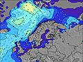 | 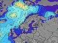 | 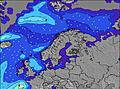 | 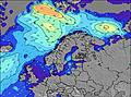 | 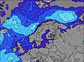 | 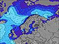 |  | 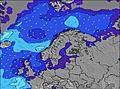 | 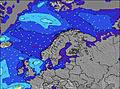 | |||||||||||||||
Onda Altezza (m) Direzione Periodo (s) | WNW 8 | WNW 8 | WNW 8 | WNW 8 | WNW 8 | WNW 8 | WNW 8 | WNW 8 | WNW 8 | WNW 8 | WNW 8 | NW 8 | NW 8 | W 7 | W 7 | WNW 7 | N 8 | W 7 | W 7 | W 7 | W 7 | W 7 | W 6 | WSW 5 |
Grafico delle onde | ||||||||||||||||||||||||
252 | 212 | 207 | 176 | 144 | 144 | 153 | 116 | 116 | 123 | 101 | 82 | 57 | 43 | 68 | 41 | 34 | 48 | 50 | 66 | 37 | 36 | 27 | 52 | |
Vento (km/h) | ||||||||||||||||||||||||
Stato del vento onshore cross-onshore cross-shore cross-offshore offshore piatto | cross-on | cross-on | cross-on | cross-on | cross-on | on | cross-on | glassy | cross | cross-off | cross-off | cross | cross | cross | cross | cross-off | cross-off | cross-off | cross-off | cross | cross | cross | cross | cross |
Alta Marea | 3:51AM2.85m | 4:28PM2.49m | 4:38AM2.75m | 5:16PM2.38m | 5:26AM2.59m | 6:07PM2.25m | ||||||||||||||||||
Basso Marea | 10:28AM0.23m | 10:34PM0.57m | 11:17AM0.35m | 11:22PM0.71m | 12:06PM0.51m | |||||||||||||||||||
2:25 | — | — | — | — | — | — | — | 2:31 | — | — | — | — | — | — | — | 2:35 | — | — | — | — | — | — | — | |
— | — | — | — | — | — | — | 11:52 | — | — | — | — | — | — | — | 11:46 | — | — | — | — | — | — | — | 11:42 | |
mm | 1 | 1 | — | — | — | 1 | — | — | 1 | — | — | — | — | — | — | — | — | — | — | 1 | — | — | — | — |
Temp. °C | 10 | 10 | 10 | 10 | 10 | 10 | 9 | 9 | 8 | 8 | 9 | 11 | 11 | 11 | 11 | 11 | 10 | 11 | 12 | 12 | 12 | 13 | 13 | 13 |
Gelo °C | 6 | 6 | 7 | 6 | 7 | 6 | 5 | 7 | 5 | 6 | 7 | 8 | 7 | 6 | 6 | 7 | 5 | 6 | 8 | 7 | 8 | 8 | 8 | 7 |
Onda 1 Altezza (m) Direzione Periodo (s) | WNW 8 | WNW 8 | WNW 8 | WNW 8 | WNW 8 | WNW 8 | WNW 8 | WNW 8 | WNW 8 | — | NW 8 | NW 8 | NW 8 | NW 7 | NNW 9 | WNW 7 | WNW 7 | W 7 | NNW 8 | NNW 8 | W 7 | W 7 | W 6 | NNW 7 |
252 | 212 | 207 | 176 | 144 | 144 | 153 | 116 | 116 | — | 59 | 82 | 57 | 27 | 43 | 41 | 27 | 48 | 21 | 19 | 37 | 36 | 27 | 10 | |
Onda 2 Altezza (m) Direzione Periodo (s) | — | — | — | W 10 | — | — | — | W 9 | W 9 | — | — | W 8 | W 8 | NW 8 | W 8 | NNW 8 | N 8 | NNW 8 | W 12 | W 12 | NNW 8 | NNW 7 | NNW 7 | W 10 |
— | — | — | 8 | — | — | — | 15 | 15 | — | — | 19 | 19 | 16 | 21 | 39 | 34 | 22 | 3 | 3 | 19 | 11 | 10 | 2 | |
Onda 3 Altezza (m) Direzione Periodo (s) | — | — | — | — | — | — | — | — | — | — | — | — | — | NW 9 | — | W 8 | W 10 | W 13 | — | — | W 12 | W 12 | W 8 | W 11 |
— | — | — | — | — | — | — | — | — | — | — | — | — | 20 | — | 20 | 8 | 3 | — | — | 3 | 3 | 4 | 2 | |
onde vento Altezza (m) Direzione Periodo (s) | — | — | — | — | — | — | — | — | — | WNW 8 | WNW 8 | W 8 | W 7 | W 7 | W 7 | SW 4 | SW 6 | SSW 3 | W 7 | W 7 | SW 4 | SSW 4 | SSW 4 | WSW 5 |
— | — | — | — | — | — | — | — | — | 123 | 101 | 64 | 40 | 43 | 68 | 4 | 16 | 1 | 50 | 66 | 6 | 5 | 8 | 52 | |
Il più vicino Offshore or Glassy | ||||||||||||||||||||||||
Distanza (km) | 1153 | 1331 | 1331 | 1331 | 1048 | 1048 | 1331 | 0 | 1074 | 0 | 0 | 156 | 156 | 147 | 147 | 147 | 147 | 147 | 156 | 156 | 1547 | 1993 | 590 | 590 |
Migliori previsioni per le condizioni d'onda in Lofoten Islands and Arctic | ||||||||||||||||||||||||
Migliori previsioni per le condizioni d'onda in Norway | ||||||||||||||||||||||||
Trova Onde Globale | ||||||||||||||||||||||||
- Map Icons:
 Break
Break Live Wave Height (m)
 Live Wind Speed (km/h)
 Surf Rating (10 Max)
 Ocean Swells (m)
- Wind Speed (km/h)
Widget Free Surf-Forecast.com per il tuo sito
La relazione di surf / widget meteo è disponibile qui sotto per incorporare su siti esterni a titolo gratuito e fornisce una sintesi delle nostre Monumentet previsione surf. Basta prendere il frammento di codice html da noi fornito e copiarlo nel proprio sito. È possibile scegliere la lingua preferita e unità metriche / imperiali per il feed delle previsioni surf per soddisfare le esigenze degli utenti del vostro sito .... Clicca qui per ottenere il codice.
 Nearest