
Venice Pier Surf Guide
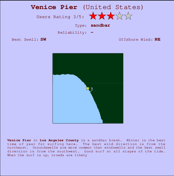
Venice Pier in Los Angeles County is an exposed sandbar break. Winter is the best time of year for surfing here. Offshore winds are from the northeast. Tends to receive distant groundswells and the best swell direction is from the southwest. Surfable at all stages of the tide. It's often crowded here.
Venice Pier Spot Info
| Type: | Rating: | Reliability: | Todays Sea Temp*: |
|---|---|---|---|
19.8°C*ocean temperature recorded from satellite |
Surfing Venice Pier:
The best conditions reported for surf at Venice Pier occur when a Southwest swell combines with an offshore wind direction from the Northeast.

Previsioni Energia d'onda (Potenza): 12hrs


Venice Pier Surf:
Friday, 3 July 2026, 05:23 Local time| Venerdì 03 | ||||
| 2AM | 5AM | 8AM | 11AM | |
| Wave (m) | ||||
| Periodo (s) | 15 | 15 | 15 | 16 |
| Vento (km/h) | ||||
| Stato del vento | glass | glass | cross | cross- on |
- /breaks/Venice-Pier/forecasts/latest
Venice Pier Surf Guide
Venice Pier in Los Angeles County is an exposed sandbar break. Winter is the best time of year for surfing here. Offshore winds are from the northeast. Tends to receive distant groundswells and the best swell direction is from the southwest. Surfable at all stages of the tide. It's often crowded here.
Venice Pier Spot Info
Type: Rating: Reliability: Todays Sea Temp*:  Sandbar
 319.8°C*ocean temperature recorded from satellite
Surfing Venice Pier:
The best conditions reported for surf at Venice Pier occur when a Southwest swell combines with an offshore wind direction from the Northeast.
Previsioni Energia d'onda (Potenza): 12hrs
Utilizzare la scheda di navigazione in alto per visualizzare Venice Pier temperatura del mare, Venice Pier fotografie, Venice Pier dettagliate previsioni onde, il vento e le previsioni meteo, Venice Pier webcam, vento corrente da CAL - LA County stazioni meteo e Venice Pier previsioni marea. Il link United States mappe maree apre l'immagine grande, che mostra United States e dei mari circostanti. Queste mappe possono essere animate per mostrare le diverse componenti del moto ondoso, energia delle onde, periodo d'onda, altezza delle onde, insieme con le previsioni del vento e meteo, meteo corrente e osservazioni sullo stato del mare dal United States onda-boe, le navi passanti e stazioni meteo costiere. Ciascuna delle pagine di previsioni per questo surf break rappresenta uno strumento di wavefinder globale e regionale per individuare le migliori condizioni di surf nella zona intorno Venice Pier.
Venice Pier Surf:
Friday, 3 July 2026, 05:23 Local timeVenerdì 03 2AM 5AM 8AM 11AM Wave (m) Periodo (s) 15 15 15 16 Vento (km/h) Stato del vento glass glass cross cross-
on- /breaks/Venice-Pier/forecasts/latest
- /breaks/Venice-Pier/forecasts/latest/six_day
Venice Pier Surf Guide
Venice Pier in Los Angeles County is an exposed sandbar break. Winter is the best time of year for surfing here. Offshore winds are from the northeast. Tends to receive distant groundswells and the best swell direction is from the southwest. Surfable at all stages of the tide. It's often crowded here.
Venice Pier Spot Info
Type: Rating: Reliability: Todays Sea Temp*: Sandbar319.8°C*ocean temperature recorded from satelliteSurfing Venice Pier:
The best conditions reported for surf at Venice Pier occur when a Southwest swell combines with an offshore wind direction from the Northeast.
Previsioni Energia d'onda (Potenza): 12hrs
Utilizzare la scheda di navigazione in alto per visualizzare Venice Pier temperatura del mare, Venice Pier fotografie, Venice Pier dettagliate previsioni onde, il vento e le previsioni meteo, Venice Pier webcam, vento corrente da CAL - LA County stazioni meteo e Venice Pier previsioni marea. Il link United States mappe maree apre l'immagine grande, che mostra United States e dei mari circostanti. Queste mappe possono essere animate per mostrare le diverse componenti del moto ondoso, energia delle onde, periodo d'onda, altezza delle onde, insieme con le previsioni del vento e meteo, meteo corrente e osservazioni sullo stato del mare dal United States onda-boe, le navi passanti e stazioni meteo costiere. Ciascuna delle pagine di previsioni per questo surf break rappresenta uno strumento di wavefinder globale e regionale per individuare le migliori condizioni di surf nella zona intorno Venice Pier.
Venice Pier Surf:
Friday, 3 July 2026, 05:23 Local timeVenerdì 03 2AM 5AM 8AM 11AM Wave (m) Periodo (s) 15 15 15 16 Vento (km/h) Stato del vento glass glass cross cross-
on- /breaks/Venice-Pier/forecasts/latest
Venice Pier Surf Guide
Venice Pier in Los Angeles County is an exposed sandbar break. Winter is the best time of year for surfing here. Offshore winds are from the northeast. Tends to receive distant groundswells and the best swell direction is from the southwest. Surfable at all stages of the tide. It's often crowded here.
Venice Pier Spot Info
Type: Rating: Reliability: Todays Sea Temp*: Sandbar319.8°C*ocean temperature recorded from satelliteSurfing Venice Pier:
The best conditions reported for surf at Venice Pier occur when a Southwest swell combines with an offshore wind direction from the Northeast.
Previsioni Energia d'onda (Potenza): 12hrs
Utilizzare la scheda di navigazione in alto per visualizzare Venice Pier temperatura del mare, Venice Pier fotografie, Venice Pier dettagliate previsioni onde, il vento e le previsioni meteo, Venice Pier webcam, vento corrente da CAL - LA County stazioni meteo e Venice Pier previsioni marea. Il link United States mappe maree apre l'immagine grande, che mostra United States e dei mari circostanti. Queste mappe possono essere animate per mostrare le diverse componenti del moto ondoso, energia delle onde, periodo d'onda, altezza delle onde, insieme con le previsioni del vento e meteo, meteo corrente e osservazioni sullo stato del mare dal United States onda-boe, le navi passanti e stazioni meteo costiere. Ciascuna delle pagine di previsioni per questo surf break rappresenta uno strumento di wavefinder globale e regionale per individuare le migliori condizioni di surf nella zona intorno Venice Pier.
Venice Pier Surf:
Friday, 3 July 2026, 05:23 Local timeVenerdì 03 2AM 5AM 8AM 11AM Wave (m) Periodo (s) 15 15 15 16 Vento (km/h) Stato del vento glass glass cross cross-
onTide Times:
Per Marina del Rey, %{dist} %{km} da %{location}.
PROSSIMA È ALLE (ora locale) rimanente alta marea bassa marea Venice Pier Tide Times and Tide Chart
Live Weather:
At BUOY-ICAC1, 5 km from Venice Pier.
light winds from the E
(km/h)Air temperature
-°CCurrent weather near Venice Pier
Buoy Data:
At Santa Monica Bay, CA, 12 miles from Venice Pier.
12AM 1AM 2AM 3AM Attualità dei dati 4 hr 3 hr 2 hr 1 hr Altezza delle onde (m) 


Periodo dominante (s) 15 17 15 17 Overall Venice Pier Surf Consistency and Wind Distribution in Luglio


Wind stats for Venice Pier: see the variation in direction and stength by month.
foto dall' album
Contorni: Strade e fiumi: seleziona un surf break dal menu 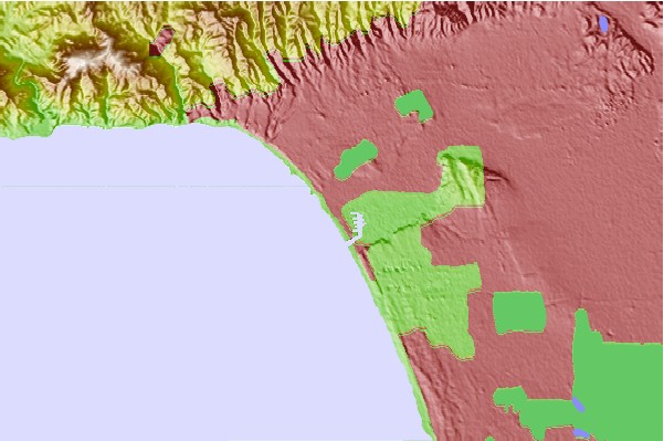
Utilizzare questa mappa sollievo per navigare CAL - LA County surf breaks e stazioni di marea che si trovano nella zona diVenice Pier
Altri surf breaks più vicini al Venice Pier:
(clicca sul nome del luogo per maggiori informazioni)- Closest località surf1 mi
- Second closest località surf1 mi
- Third closest località surf1 mi
- Fourth closest località surf2 mi
- Fifth closest località surf2 mi
Onda boe più vicina a Venice Pier:
- Closest Onda boa12 mi
- Second closest Onda boa25 mi
- Third closest Onda boa26 mi
- Fourth closest Onda boa32 mi
- Fifth closest Onda boa36 mi
Stazioni di marea più vicina alla Venice Pier:
- Closest marea stazioneMarina del Rey1 mi
- Second closest marea stazioneSanta Monica2 mi
- Third closest marea stazioneEl Segundo, Santa Monica Bay5 mi
- Fourth closest marea stazioneManhattan Beach7 mi
- Fifth closest marea stazioneKing Harbor, Santa Monica Bay10 mi
Airports
- The closest passenger airport to Venice Pier is Los Angeles International Airport (LAX) in USA, 7 km (4 miles) away (directly).
- The second nearest airport to Venice Pier is Jack Northrop Fld Hawthorne Muni Airport (HHR), also in USA, 14 km (9 miles) away.
- Third is Burbank Glendale Pasadena Airport (BUR) in USA, 27 km (17 miles) away.
- Long Beach Airport (LGB) in USA is 34 km (21 miles) away.
- Point Mugu Nas Airport (NTD), also in USA is the fifth nearest airport to Venice Pier and is 62 km (39 miles) away.
- /breaks/Venice-Pier/forecasts/latest

 Nearest