
Previsioni:

Previsione a breve terminepioggia leggera (Totale 5mm), per lo più che cade martedì mattina. Warm (Max 28°C Lunedì pomeriggio, Min 27°C Lunedì notte). Vento sarà generalmente leggero. | ||||||||||||||||||||
Lun 3 | Martedì 4 | Mercoledì 5 | ||||||||||||||||||
2 PM | 5 PM | 8 PM | 11 PM | 2 AM | 5 AM | 8 AM | 11 AM | 2 PM | 5 PM | 8 PM | 11 PM | 2 AM | 5 AM | 8 AM | 11 AM | 2 PM | 5 PM | 8 PM | 11 PM | |
Mappa dell'altezza del moto ondoso | 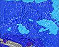 | 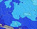 | 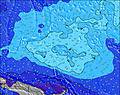 | 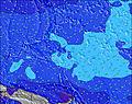 | 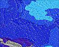 | 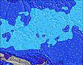 | 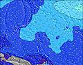 | 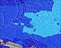 | ||||||||||||
Onda Altezza (m) Direzione Periodo (s) | WNW 9 | NNW 12 | NNW 12 | NNW 13 | NNW 13 | NNW 13 | NNW 13 | WNW 10 | WNW 10 | WNW 10 | WNW 10 | WNW 9 | WNW 9 | WNW 9 | WNW 9 | WNW 9 | WNW 9 | WNW 10 | WNW 10 | WNW 10 |
Grafico delle onde | ||||||||||||||||||||
250 | 250 | 212 | 298 | 326 | 384 | 307 | 296 | 308 | 275 | 264 | 212 | 203 | 203 | 249 | 286 | 272 | 340 | 327 | 314 | |
Vento (km/h) | ||||||||||||||||||||
Stato del vento onshore cross-onshore cross-shore cross-offshore offshore piatto | cross-on | cross-on | cross-on | glassy | cross | cross | cross | cross | cross | cross | cross | cross-off | cross-off | cross-off | cross-off | cross-off | cross-off | cross | cross-off | cross-off |
Alta Marea | 6:02PM1.32m | 6:03AM1.35m | 6:38PM1.30m | 6:37AM1.19m | 7:23PM1.25m | |||||||||||||||
Basso Marea | 11:58PM0.28m | 12:19PM0.19m | 00:41AM0.37m | 12:50PM0.28m | ||||||||||||||||
— | — | — | — | — | 6:03 | — | — | — | — | — | — | — | 6:03 | — | — | — | — | — | — | |
— | 6:23 | — | — | — | — | — | — | — | 6:23 | — | — | — | — | — | — | — | 6:23 | — | — | |
mm | — | — | — | — | 1 | 1 | 1 | 2 | — | — | — | — | — | — | — | — | — | — | — | — |
Temp. °C | 28 | 28 | 28 | 28 | 27 | 28 | 28 | 28 | 28 | 28 | 28 | 28 | 27 | 27 | 27 | 28 | 28 | 28 | 28 | 28 |
Gelo °C | 31 | 31 | 32 | 33 | 31 | 32 | 31 | 30 | 30 | 31 | 31 | 32 | 30 | 30 | 30 | 31 | 30 | 30 | 31 | 31 |
Onda 1 Altezza (m) Direzione Periodo (s) | WNW 9 | WNW 9 | WNW 9 | WNW 9 | WNW 9 | WNW 9 | WNW 9 | WNW 10 | WNW 10 | WNW 10 | WNW 10 | WNW 9 | WNW 9 | WNW 9 | WNW 9 | WNW 9 | WNW 9 | WNW 10 | WNW 10 | WNW 10 |
238 | 217 | 212 | 181 | 190 | 199 | 212 | 296 | 308 | 275 | 264 | 212 | 203 | 203 | 249 | 255 | 272 | 340 | 327 | 314 | |
Onda 2 Altezza (m) Direzione Periodo (s) | NNW 12 | NNW 12 | NNW 12 | NNW 13 | NNW 13 | NNW 13 | NNW 13 | NNW 12 | NNW 12 | NNW 12 | NNW 12 | NNW 12 | NNW 12 | NNW 11 | NNW 11 | NNW 13 | NNW 12 | NNW 12 | NNW 12 | NNW 12 |
250 | 250 | 206 | 298 | 326 | 384 | 307 | 278 | 274 | 230 | 222 | 158 | 150 | 157 | 111 | 286 | 268 | 255 | 251 | 260 | |
Onda 3 Altezza (m) Direzione Periodo (s) | SSE 9 | SE 9 | SW 8 | SW 8 | SSE 9 | SE 9 | SE 9 | SW 7 | SSE 8 | SE 8 | SE 8 | SW 7 | SSE 10 | S 10 | S 10 | S 10 | S 10 | S 10 | S 10 | SSE 10 |
108 | 84 | 57 | 55 | 103 | 81 | 77 | 42 | 64 | 72 | 58 | 28 | 62 | 50 | 73 | 73 | 130 | 127 | 127 | 167 | |
onde vento Altezza (m) Direzione Periodo (s) | — | — | — | — | — | — | — | — | — | — | — | — | — | — | — | — | SW 6 | SW 6 | — | — |
— | — | — | — | — | — | — | — | — | — | — | — | — | — | — | — | 10 | 20 | — | — | |
Il più vicino Offshore or Glassy | ||||||||||||||||||||
Distanza (km) | 1612 | 2382 | 1607 | 0 | 1187 | 1187 | 1187 | 1187 | 1612 | 1607 | 1187 | 0 | 0 | 0 | 0 | 0 | 1187 | 1187 | 0 | 1187 |
Migliori previsioni per le condizioni d'onda in Micronesia - Kosrae | ||||||||||||||||||||
Migliori previsioni per le condizioni d'onda in Micronesia | ||||||||||||||||||||
Trova Onde Globale | ||||||||||||||||||||
- Map Icons:
 Break
Break Live Wave Height (m)
 Live Wind Speed (km/h)
 Surf Rating (10 Max)
 Ocean Swells (m)
- Wind Speed (km/h)
Widget Free Surf-Forecast.com per il tuo sito
La relazione di surf / widget meteo è disponibile qui sotto per incorporare su siti esterni a titolo gratuito e fornisce una sintesi delle nostre Walung previsione surf. Basta prendere il frammento di codice html da noi fornito e copiarlo nel proprio sito. È possibile scegliere la lingua preferita e unità metriche / imperiali per il feed delle previsioni surf per soddisfare le esigenze degli utenti del vostro sito .... Clicca qui per ottenere il codice.
 Nearest