

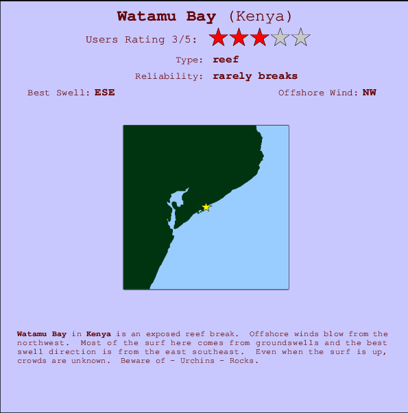
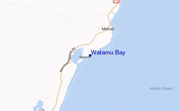
Watamu Bay Surf Guide
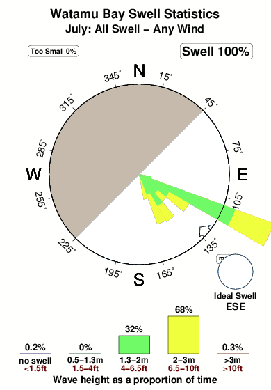
Watamu Bay in Kenya is an exposed reef break. Offshore winds blow from the northwest. Most of the surf here comes from groundswells and the ideal swell angle is from the east southeast. An uncrowded break, even when it is working. Beware of - Urchins - Rocks.
Watamu Bay Spot Info
| Type: | Rating: | Reliability: | Todays Sea Temp*: |
|---|---|---|---|
| rarely breaks | 26.0°C*ocean temperature recorded from satellite |
Surfing Watamu Bay:
The best conditions reported for surf at Watamu Bay occur when a East-southeast swell combines with an offshore wind direction from the Northwest.
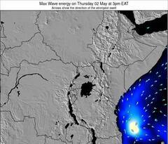
Previsioni Energia d'onda (Potenza): 12hrs
Watamu Bay Surf:
Sunday, 26 July 2026, 03:30 Local time| Domenica 26 | ||||
| 0AM | 3AM | 6AM | 9AM | |
| Wave (m) | ||||
| Periodo (s) | 9 | 9 | 9 | 9 |
| Vento (km/h) | ||||
| Stato del vento | cross- on |
cross- on |
cross- on |
cross- on |
- /breaks/Watamu-Bay/forecasts/latest
Watamu Bay Surf Guide
Watamu Bay in Kenya is an exposed reef break. Offshore winds blow from the northwest. Most of the surf here comes from groundswells and the ideal swell angle is from the east southeast. An uncrowded break, even when it is working. Beware of - Urchins - Rocks.
Watamu Bay Spot Info
Type: Rating: Reliability: Todays Sea Temp*:  Reef
Reef 3
3rarely breaks 26.0°C*ocean temperature recorded from satelliteSurfing Watamu Bay:
The best conditions reported for surf at Watamu Bay occur when a East-southeast swell combines with an offshore wind direction from the Northwest.
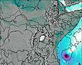
Previsioni Energia d'onda (Potenza): 12hrs
Utilizzare la scheda di navigazione in alto per visualizzare Watamu Bay temperatura del mare, Watamu Bay fotografie, Watamu Bay dettagliate previsioni onde, il vento e le previsioni meteo, Watamu Bay webcam, vento corrente da Kenya stazioni meteo e Watamu Bay previsioni marea. Il link Kenya mappe maree apre l'immagine grande, che mostra Kenya e dei mari circostanti. Queste mappe possono essere animate per mostrare le diverse componenti del moto ondoso, energia delle onde, periodo d'onda, altezza delle onde, insieme con le previsioni del vento e meteo, meteo corrente e osservazioni sullo stato del mare dal Kenya onda-boe, le navi passanti e stazioni meteo costiere. Ciascuna delle pagine di previsioni per questo surf break rappresenta uno strumento di wavefinder globale e regionale per individuare le migliori condizioni di surf nella zona intorno Watamu Bay.
Watamu Bay Surf:
Sunday, 26 July 2026, 03:30 Local timeDomenica 26 0AM 3AM 6AM 9AM Wave (m) Periodo (s) 9 9 9 9 Vento (km/h) Stato del vento cross-
oncross-
oncross-
oncross-
on- /breaks/Watamu-Bay/forecasts/latest
- /breaks/Watamu-Bay/forecasts/latest/six_day
Watamu Bay Surf Guide
Watamu Bay in Kenya is an exposed reef break. Offshore winds blow from the northwest. Most of the surf here comes from groundswells and the ideal swell angle is from the east southeast. An uncrowded break, even when it is working. Beware of - Urchins - Rocks.
Watamu Bay Spot Info
Type: Rating: Reliability: Todays Sea Temp*: Reef3rarely breaks 26.0°C*ocean temperature recorded from satelliteSurfing Watamu Bay:
The best conditions reported for surf at Watamu Bay occur when a East-southeast swell combines with an offshore wind direction from the Northwest.
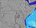
Previsioni Energia d'onda (Potenza): 12hrs
Utilizzare la scheda di navigazione in alto per visualizzare Watamu Bay temperatura del mare, Watamu Bay fotografie, Watamu Bay dettagliate previsioni onde, il vento e le previsioni meteo, Watamu Bay webcam, vento corrente da Kenya stazioni meteo e Watamu Bay previsioni marea. Il link Kenya mappe maree apre l'immagine grande, che mostra Kenya e dei mari circostanti. Queste mappe possono essere animate per mostrare le diverse componenti del moto ondoso, energia delle onde, periodo d'onda, altezza delle onde, insieme con le previsioni del vento e meteo, meteo corrente e osservazioni sullo stato del mare dal Kenya onda-boe, le navi passanti e stazioni meteo costiere. Ciascuna delle pagine di previsioni per questo surf break rappresenta uno strumento di wavefinder globale e regionale per individuare le migliori condizioni di surf nella zona intorno Watamu Bay.
Watamu Bay Surf:
Sunday, 26 July 2026, 03:30 Local timeDomenica 26 0AM 3AM 6AM 9AM Wave (m) Periodo (s) 9 9 9 9 Vento (km/h) Stato del vento cross-
oncross-
oncross-
oncross-
on- /breaks/Watamu-Bay/forecasts/latest
Watamu Bay Surf Guide
Watamu Bay in Kenya is an exposed reef break. Offshore winds blow from the northwest. Most of the surf here comes from groundswells and the ideal swell angle is from the east southeast. An uncrowded break, even when it is working. Beware of - Urchins - Rocks.
Watamu Bay Spot Info
Type: Rating: Reliability: Todays Sea Temp*: Reef3rarely breaks 26.0°C*ocean temperature recorded from satelliteSurfing Watamu Bay:
The best conditions reported for surf at Watamu Bay occur when a East-southeast swell combines with an offshore wind direction from the Northwest.
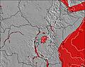
Previsioni Energia d'onda (Potenza): 12hrs
Utilizzare la scheda di navigazione in alto per visualizzare Watamu Bay temperatura del mare, Watamu Bay fotografie, Watamu Bay dettagliate previsioni onde, il vento e le previsioni meteo, Watamu Bay webcam, vento corrente da Kenya stazioni meteo e Watamu Bay previsioni marea. Il link Kenya mappe maree apre l'immagine grande, che mostra Kenya e dei mari circostanti. Queste mappe possono essere animate per mostrare le diverse componenti del moto ondoso, energia delle onde, periodo d'onda, altezza delle onde, insieme con le previsioni del vento e meteo, meteo corrente e osservazioni sullo stato del mare dal Kenya onda-boe, le navi passanti e stazioni meteo costiere. Ciascuna delle pagine di previsioni per questo surf break rappresenta uno strumento di wavefinder globale e regionale per individuare le migliori condizioni di surf nella zona intorno Watamu Bay.
Watamu Bay Surf:
Sunday, 26 July 2026, 03:30 Local timeDomenica 26 0AM 3AM 6AM 9AM Wave (m) Periodo (s) 9 9 9 9 Vento (km/h) Stato del vento cross-
oncross-
oncross-
oncross-
onTide Times:
A Watamu Bay (0 km).
PROSSIMA È ALLE (ora locale) rimanente alta marea bassa marea Watamu Bay Tide Times and Tide Chart
Live Weather:
At Mombasa-Moi International Airport, 86 km from Watamu Bay.
light winds from the S
(km/h)
Dry and partly cloudyAir temperature
24°COverall Watamu Bay Surf Consistency and Wind Distribution in Luglio
foto dall' album
Contorni: Strade e fiumi: seleziona un surf break dal menu 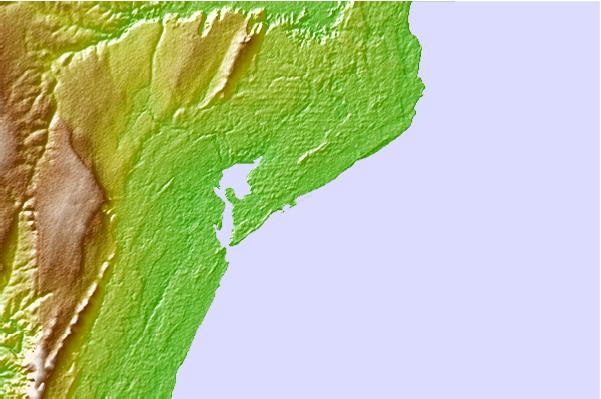
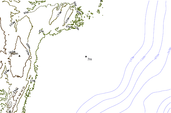
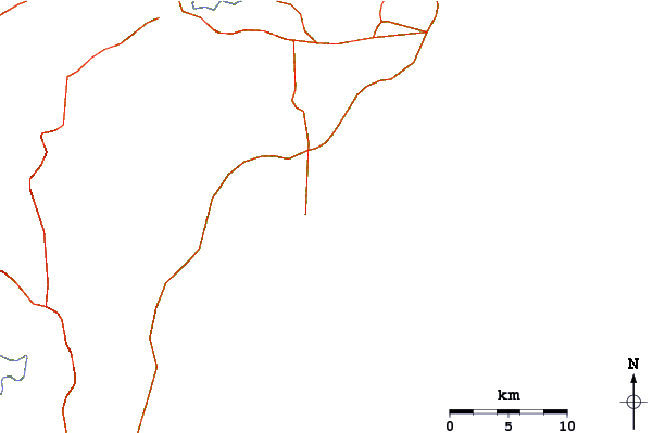
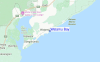
Utilizzare questa mappa sollievo per navigare Kenya surf breaks e stazioni di marea che si trovano nella zona diWatamu Bay
Altri surf breaks più vicini al Watamu Bay:
(clicca sul nome del luogo per maggiori informazioni)- Closest località surf12 mi
- Second closest località surf56 mi
- Third closest località surf171 mi
- Fourth closest località surf238 mi
- Fifth closest località surf240 mi
Onda boe più vicina a Watamu Bay:
- Closest Onda boa2775 mi
- Second closest Onda boa3809 mi
- Third closest Onda boa3850 mi
- Fourth closest Onda boa4162 mi
- Fifth closest Onda boa4248 mi
Stazioni di marea più vicina alla Watamu Bay:
- Closest marea stazioneMalindi11 mi
- Second closest marea stazioneKilifi23 mi
- Third closest marea stazioneTakaungu26 mi
- Fourth closest marea stazioneKilindini Harbour57 mi
- Fifth closest marea stazioneGazi82 mi
Airports
- The closest passenger airport to Watamu Bay is Malindi Airport (MYD) in Kenya, which is 16 km (10 miles) away (directly).
- The second nearest airport to Watamu Bay is Moi International (Mombasa) Airport (MBA), also in Kenya, 90 km (56 miles) away.
- The third closest airport is Lamu Manda Airport (LAU), also in Kenya, 157 km (98 miles) away.
- /breaks/Watamu-Bay/forecasts/latest


 Nearest