

Way Jambu Surf Guide
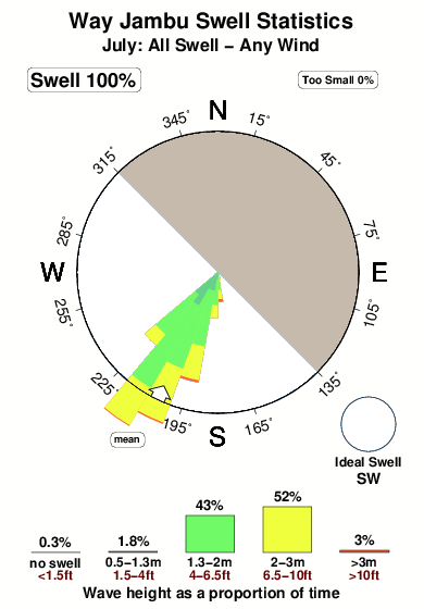
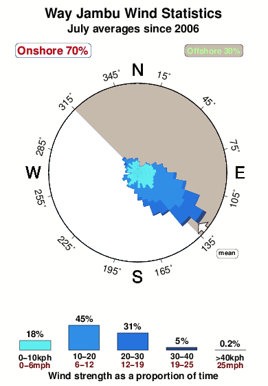
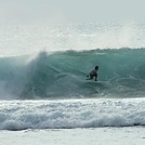
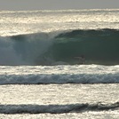
Way Jambu in Sumatra is an exposed reef and point break that has consistent surf. May-Oct (Dry Season) is the optimum time of year for waves. The best wind direction is from the northeast. Groundswells more frequent than windswells and the ideal swell angle is from the southwest.There is a left hand point break here. Best around high tide. Rarely crowded here. Watch out for rocks.
Way Jambu Spot Info
| Type: | Rating: | Reliability: | Todays Sea Temp*: |
|---|---|---|---|
| consistent | 29.2°C*ocean temperature recorded from satellite |
Surfing Way Jambu:
The best conditions reported for surf at Way Jambu occur when a Southwest swell combines with an offshore wind direction from the Northeast.

Previsioni Energia d'onda (Potenza): 12hrs


Way Jambu Surf:
Sunday, 19 July 2026, 11:49 Local time| Domenica 19 | ||||
| 10AM | 1PM | 4PM | 7PM | |
| Wave (m) | ||||
| Periodo (s) | 13 | 17 | 17 | 16 |
| Vento (km/h) | ||||
| Stato del vento | cross | cross- on |
cross | cross |
- /breaks/Way-Jambu/forecasts/latest
Way Jambu Surf Guide
Way Jambu in Sumatra is an exposed reef and point break that has consistent surf. May-Oct (Dry Season) is the optimum time of year for waves. The best wind direction is from the northeast. Groundswells more frequent than windswells and the ideal swell angle is from the southwest.There is a left hand point break here. Best around high tide. Rarely crowded here. Watch out for rocks.
Way Jambu Spot Info
Type: Rating: Reliability: Todays Sea Temp*:  Reef and point
 5
5consistent 29.2°C*ocean temperature recorded from satelliteSurfing Way Jambu:
The best conditions reported for surf at Way Jambu occur when a Southwest swell combines with an offshore wind direction from the Northeast.
Previsioni Energia d'onda (Potenza): 12hrs
Utilizzare la scheda di navigazione in alto per visualizzare Way Jambu temperatura del mare, Way Jambu fotografie, Way Jambu dettagliate previsioni onde, il vento e le previsioni meteo, Way Jambu webcam, vento corrente da Sumatra - Mainland stazioni meteo e Way Jambu previsioni marea. Il link Indonesia mappe maree apre l'immagine grande, che mostra Indonesia e dei mari circostanti. Queste mappe possono essere animate per mostrare le diverse componenti del moto ondoso, energia delle onde, periodo d'onda, altezza delle onde, insieme con le previsioni del vento e meteo, meteo corrente e osservazioni sullo stato del mare dal Indonesia onda-boe, le navi passanti e stazioni meteo costiere. Ciascuna delle pagine di previsioni per questo surf break rappresenta uno strumento di wavefinder globale e regionale per individuare le migliori condizioni di surf nella zona intorno Way Jambu.
Way Jambu Surf:
Sunday, 19 July 2026, 11:49 Local timeDomenica 19 10AM 1PM 4PM 7PM Wave (m) Periodo (s) 13 17 17 16 Vento (km/h) Stato del vento cross cross-
oncross cross - /breaks/Way-Jambu/forecasts/latest
- /breaks/Way-Jambu/forecasts/latest/six_day
Way Jambu Surf Guide
Way Jambu in Sumatra is an exposed reef and point break that has consistent surf. May-Oct (Dry Season) is the optimum time of year for waves. The best wind direction is from the northeast. Groundswells more frequent than windswells and the ideal swell angle is from the southwest.There is a left hand point break here. Best around high tide. Rarely crowded here. Watch out for rocks.
Way Jambu Spot Info
Type: Rating: Reliability: Todays Sea Temp*: Reef and point5consistent 29.2°C*ocean temperature recorded from satelliteSurfing Way Jambu:
The best conditions reported for surf at Way Jambu occur when a Southwest swell combines with an offshore wind direction from the Northeast.
Previsioni Energia d'onda (Potenza): 12hrs
Utilizzare la scheda di navigazione in alto per visualizzare Way Jambu temperatura del mare, Way Jambu fotografie, Way Jambu dettagliate previsioni onde, il vento e le previsioni meteo, Way Jambu webcam, vento corrente da Sumatra - Mainland stazioni meteo e Way Jambu previsioni marea. Il link Indonesia mappe maree apre l'immagine grande, che mostra Indonesia e dei mari circostanti. Queste mappe possono essere animate per mostrare le diverse componenti del moto ondoso, energia delle onde, periodo d'onda, altezza delle onde, insieme con le previsioni del vento e meteo, meteo corrente e osservazioni sullo stato del mare dal Indonesia onda-boe, le navi passanti e stazioni meteo costiere. Ciascuna delle pagine di previsioni per questo surf break rappresenta uno strumento di wavefinder globale e regionale per individuare le migliori condizioni di surf nella zona intorno Way Jambu.
Way Jambu Surf:
Sunday, 19 July 2026, 11:49 Local timeDomenica 19 10AM 1PM 4PM 7PM Wave (m) Periodo (s) 13 17 17 16 Vento (km/h) Stato del vento cross cross-
oncross cross - /breaks/Way-Jambu/forecasts/latest
Way Jambu Surf Guide
Way Jambu in Sumatra is an exposed reef and point break that has consistent surf. May-Oct (Dry Season) is the optimum time of year for waves. The best wind direction is from the northeast. Groundswells more frequent than windswells and the ideal swell angle is from the southwest.There is a left hand point break here. Best around high tide. Rarely crowded here. Watch out for rocks.
Way Jambu Spot Info
Type: Rating: Reliability: Todays Sea Temp*: Reef and point5consistent 29.2°C*ocean temperature recorded from satelliteSurfing Way Jambu:
The best conditions reported for surf at Way Jambu occur when a Southwest swell combines with an offshore wind direction from the Northeast.
Previsioni Energia d'onda (Potenza): 12hrs
Utilizzare la scheda di navigazione in alto per visualizzare Way Jambu temperatura del mare, Way Jambu fotografie, Way Jambu dettagliate previsioni onde, il vento e le previsioni meteo, Way Jambu webcam, vento corrente da Sumatra - Mainland stazioni meteo e Way Jambu previsioni marea. Il link Indonesia mappe maree apre l'immagine grande, che mostra Indonesia e dei mari circostanti. Queste mappe possono essere animate per mostrare le diverse componenti del moto ondoso, energia delle onde, periodo d'onda, altezza delle onde, insieme con le previsioni del vento e meteo, meteo corrente e osservazioni sullo stato del mare dal Indonesia onda-boe, le navi passanti e stazioni meteo costiere. Ciascuna delle pagine di previsioni per questo surf break rappresenta uno strumento di wavefinder globale e regionale per individuare le migliori condizioni di surf nella zona intorno Way Jambu.
Way Jambu Surf:
Sunday, 19 July 2026, 11:49 Local timeDomenica 19 10AM 1PM 4PM 7PM Wave (m) Periodo (s) 13 17 17 16 Vento (km/h) Stato del vento cross cross-
oncross cross Tide Times:
Per Bali Village, %{dist} %{km} da %{location}.
PROSSIMA È ALLE (ora locale) rimanente alta marea bassa marea Way Jambu Tide Times and Tide Chart
Live Weather:
At Palembang/Sultan Mahmud Badaruddin II Airport, 283 km from Way Jambu.
light winds from the SE
(km/h)
Dry and partly cloudyAir temperature
30°COverall Way Jambu Surf Consistency and Wind Distribution in Luglio
foto dall' album
Contorni: Strade e fiumi: seleziona un surf break dal menu 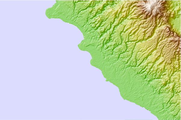
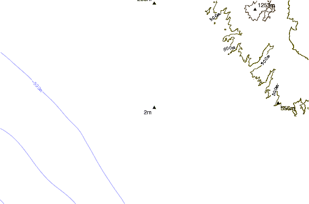
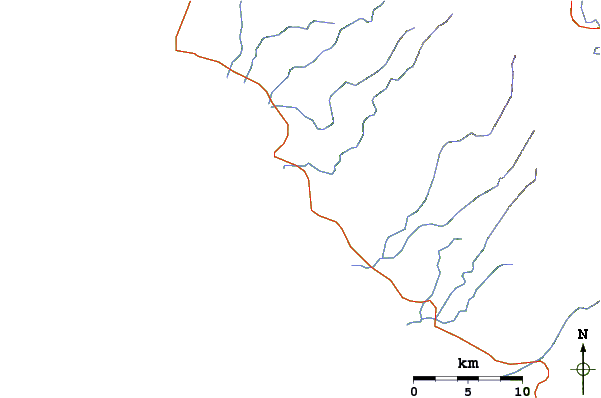
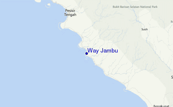
Utilizzare questa mappa sollievo per navigare Sumatra - Mainland surf breaks e stazioni di marea che si trovano nella zona diWay Jambu
Altri surf breaks più vicini al Way Jambu:
(clicca sul nome del luogo per maggiori informazioni)- Closest località surf2 mi
- Second closest località surf4 mi
- Third closest località surf8 mi
- Fourth closest località surf13 mi
- Fifth closest località surf13 mi
Onda boe più vicina a Way Jambu:
- Closest Onda boa2460 mi
- Second closest Onda boa2529 mi
- Third closest Onda boa2618 mi
- Fourth closest Onda boa2699 mi
- Fifth closest Onda boa2711 mi
Stazioni di marea più vicina alla Way Jambu:
- Closest marea stazioneBandar Lampung88 mi
- Second closest marea stazioneLabuhan143 mi
- Third closest marea stazioneBengkulu162 mi
- Fourth closest marea stazioneJakarta195 mi
- Fifth closest marea stazioneTanjung Priok202 mi
Airports
- The nearest passenger airport to Way Jambu is Padang Kemiling (Bengkulu) Airport (BKS) in Indonesia, which is 249 km (155 miles) away (directly).
- The second closest airport to Way Jambu is Sultan Mahmud Badaruddin Ii (Palembang) Airport (PLM), also in Indonesia, 283 km (176 miles) away.
- /breaks/Way-Jambu/forecasts/latest


 Nearest