
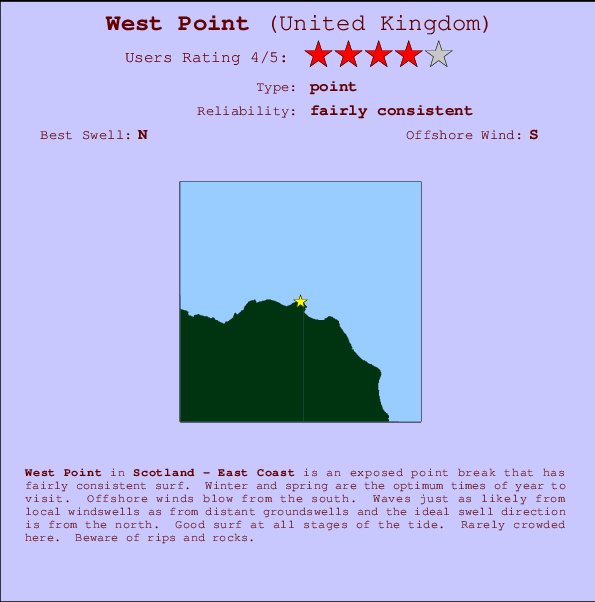
West Point Surf Guide
West Point on the East Coast is an exposed point break that has fairly consistent surf. Winter and spring are the optimum times of year to visit. The best wind direction is from the south. Groundswells and windswells are equally likely and the ideal swell angle is from the north. Surfable at all stages of the tide. It very rarely gets crowded here. Beware of rips and rocks.
West Point Spot Info
| Type: | Rating: | Reliability: | Todays Sea Temp*: |
|---|---|---|---|
| fairly consistent | 14.7°C*ocean temperature recorded from satellite |
Surfing West Point:
The best conditions reported for surf at West Point occur when a North swell combines with an offshore wind direction from the South.
Previsioni Energia d'onda (Potenza): 12hrs


West Point Surf:
Monday, 3 August 2026, 09:39 Local time| Lunedì 03 | ||||
| 10AM | 1PM | 4PM | 7PM | |
| Wave (m) | ||||
| Periodo (s) | 9 | 9 | 9 | 9 |
| Vento (km/h) | ||||
| Stato del vento | cross- off |
cross- off |
cross- off |
cross- off |
- /breaks/West-Point/forecasts/latest
West Point Surf Guide
West Point on the East Coast is an exposed point break that has fairly consistent surf. Winter and spring are the optimum times of year to visit. The best wind direction is from the south. Groundswells and windswells are equally likely and the ideal swell angle is from the north. Surfable at all stages of the tide. It very rarely gets crowded here. Beware of rips and rocks.
West Point Spot Info
Type: Rating: Reliability: Todays Sea Temp*:  Point
Point 4
4fairly consistent 14.7°C*ocean temperature recorded from satelliteSurfing West Point:
The best conditions reported for surf at West Point occur when a North swell combines with an offshore wind direction from the South.
Previsioni Energia d'onda (Potenza): 12hrs
Utilizzare la scheda di navigazione in alto per visualizzare West Point temperatura del mare, West Point fotografie, West Point dettagliate previsioni onde, il vento e le previsioni meteo, West Point webcam, vento corrente da Scot - East Coast stazioni meteo e West Point previsioni marea. Il link United Kingdom mappe maree apre l'immagine grande, che mostra United Kingdom e dei mari circostanti. Queste mappe possono essere animate per mostrare le diverse componenti del moto ondoso, energia delle onde, periodo d'onda, altezza delle onde, insieme con le previsioni del vento e meteo, meteo corrente e osservazioni sullo stato del mare dal United Kingdom onda-boe, le navi passanti e stazioni meteo costiere. Ciascuna delle pagine di previsioni per questo surf break rappresenta uno strumento di wavefinder globale e regionale per individuare le migliori condizioni di surf nella zona intorno West Point.
West Point Surf:
Monday, 3 August 2026, 09:39 Local timeLunedì 03 10AM 1PM 4PM 7PM Wave (m) Periodo (s) 9 9 9 9 Vento (km/h) Stato del vento cross-
offcross-
offcross-
offcross-
off- /breaks/West-Point/forecasts/latest
- /breaks/West-Point/forecasts/latest/six_day
West Point Surf Guide
West Point on the East Coast is an exposed point break that has fairly consistent surf. Winter and spring are the optimum times of year to visit. The best wind direction is from the south. Groundswells and windswells are equally likely and the ideal swell angle is from the north. Surfable at all stages of the tide. It very rarely gets crowded here. Beware of rips and rocks.
West Point Spot Info
Type: Rating: Reliability: Todays Sea Temp*: Point4fairly consistent 14.7°C*ocean temperature recorded from satelliteSurfing West Point:
The best conditions reported for surf at West Point occur when a North swell combines with an offshore wind direction from the South.
Previsioni Energia d'onda (Potenza): 12hrs
Utilizzare la scheda di navigazione in alto per visualizzare West Point temperatura del mare, West Point fotografie, West Point dettagliate previsioni onde, il vento e le previsioni meteo, West Point webcam, vento corrente da Scot - East Coast stazioni meteo e West Point previsioni marea. Il link United Kingdom mappe maree apre l'immagine grande, che mostra United Kingdom e dei mari circostanti. Queste mappe possono essere animate per mostrare le diverse componenti del moto ondoso, energia delle onde, periodo d'onda, altezza delle onde, insieme con le previsioni del vento e meteo, meteo corrente e osservazioni sullo stato del mare dal United Kingdom onda-boe, le navi passanti e stazioni meteo costiere. Ciascuna delle pagine di previsioni per questo surf break rappresenta uno strumento di wavefinder globale e regionale per individuare le migliori condizioni di surf nella zona intorno West Point.
West Point Surf:
Monday, 3 August 2026, 09:39 Local timeLunedì 03 10AM 1PM 4PM 7PM Wave (m) Periodo (s) 9 9 9 9 Vento (km/h) Stato del vento cross-
offcross-
offcross-
offcross-
off- /breaks/West-Point/forecasts/latest
West Point Surf Guide
West Point on the East Coast is an exposed point break that has fairly consistent surf. Winter and spring are the optimum times of year to visit. The best wind direction is from the south. Groundswells and windswells are equally likely and the ideal swell angle is from the north. Surfable at all stages of the tide. It very rarely gets crowded here. Beware of rips and rocks.
West Point Spot Info
Type: Rating: Reliability: Todays Sea Temp*: Point4fairly consistent 14.7°C*ocean temperature recorded from satelliteSurfing West Point:
The best conditions reported for surf at West Point occur when a North swell combines with an offshore wind direction from the South.
Previsioni Energia d'onda (Potenza): 12hrs
Utilizzare la scheda di navigazione in alto per visualizzare West Point temperatura del mare, West Point fotografie, West Point dettagliate previsioni onde, il vento e le previsioni meteo, West Point webcam, vento corrente da Scot - East Coast stazioni meteo e West Point previsioni marea. Il link United Kingdom mappe maree apre l'immagine grande, che mostra United Kingdom e dei mari circostanti. Queste mappe possono essere animate per mostrare le diverse componenti del moto ondoso, energia delle onde, periodo d'onda, altezza delle onde, insieme con le previsioni del vento e meteo, meteo corrente e osservazioni sullo stato del mare dal United Kingdom onda-boe, le navi passanti e stazioni meteo costiere. Ciascuna delle pagine di previsioni per questo surf break rappresenta uno strumento di wavefinder globale e regionale per individuare le migliori condizioni di surf nella zona intorno West Point.
West Point Surf:
Monday, 3 August 2026, 09:39 Local timeLunedì 03 10AM 1PM 4PM 7PM Wave (m) Periodo (s) 9 9 9 9 Vento (km/h) Stato del vento cross-
offcross-
offcross-
offcross-
offTide Times:
A Fraserburgh (0 km).
PROSSIMA È ALLE (ora locale) rimanente alta marea bassa marea West Point Tide Times and Tide Chart
Live Weather:
At SHIP9045, 49 km from West Point.
moderate winds from the SE
(km/h)Air temperature
-°CCurrent weather near West Point
Buoy Data:
At Moray Firth WaveNet Site, 52 miles from West Point.
4AM 5AM 6AM 7AM Attualità dei dati 4 hr 3 hr 2 hr 1 hr Altezza delle onde (m) 

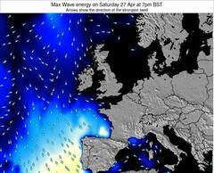
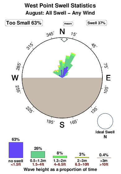
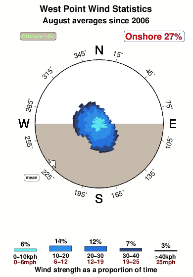
Periodo dominante (s) 3.4 3.4 3.1 Overall West Point Surf Consistency and Wind Distribution in Agosto
foto dall' album
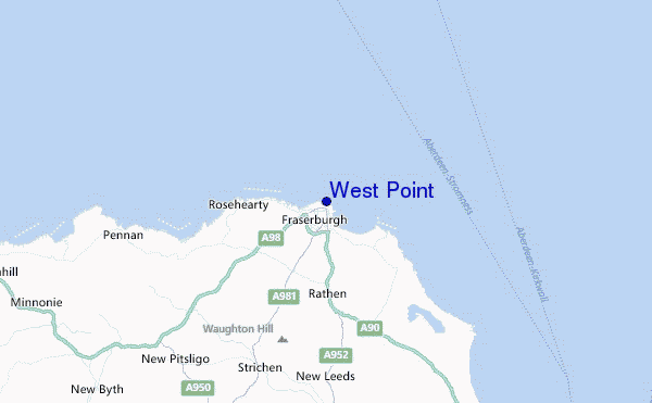
Contorni: Strade e fiumi: seleziona un surf break dal menu 
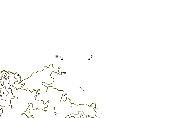
Utilizzare questa mappa sollievo per navigare Scot - East Coast surf breaks e stazioni di marea che si trovano nella zona diWest Point
Altri surf breaks più vicini al West Point:
(clicca sul nome del luogo per maggiori informazioni)- Closest località surf1 mi
- Second closest località surf1 mi
- Third closest località surf2 mi
- Fourth closest località surf2 mi
- Fifth closest località surf4 mi
Onda boe più vicina a West Point:
- Closest Onda boa52 mi
- Second closest Onda boa79 mi
- Third closest Onda boa93 mi
- Fourth closest Onda boa99 mi
- Fifth closest Onda boa99 mi
Stazioni di marea più vicina alla West Point:
- Closest marea stazioneFraserburgh0 mi
- Second closest marea stazionePeterhead16 mi
- Third closest marea stazioneBuckie35 mi
- Fourth closest marea stazioneAberdeen39 mi
- Fifth closest marea stazionePortlethen45 mi
Airports
- The closest passenger airport to West Point is Dyce (Aberdeen) Airport (ABZ) in U.k, 56 km (35 miles) away (directly).
- The second nearest airport to West Point is Lossiemouth Airport (LMO), also in U.k, 79 km (49 miles) away.
- Third is Wick Airport (WIC) in U.k., 106 km (66 miles) away.
- Inverness Airport (INV) in U.k is 123 km (76 miles) away.
- Kirkwall Airport (KOI) in Scotland is the fifth nearest airport to West Point and is 150 km (93 miles) away.
- /breaks/West-Point/forecasts/latest


 Nearest