

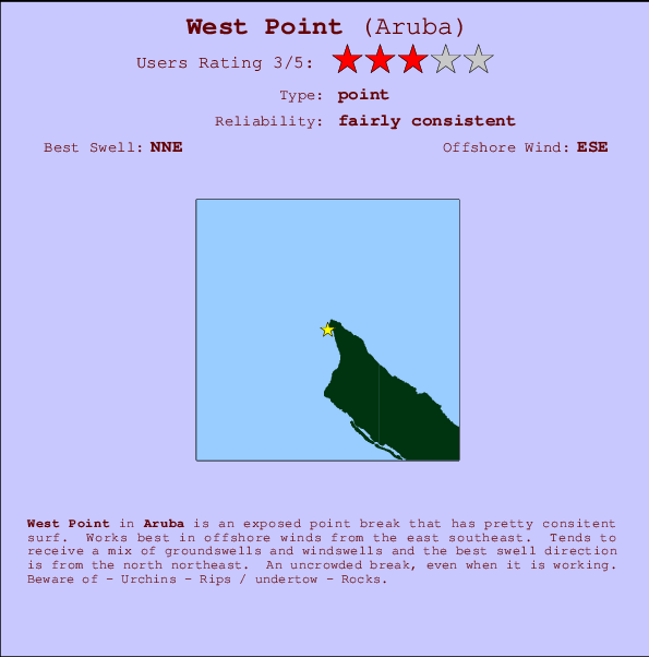
West Point Surf Guide
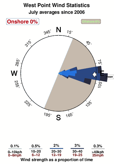
West Point in Aruba is an exposed point break that has reasonably consistent surf. Offshore winds blow from the east southeast. Waves just as likely from local windswells as from distant groundswells and the optimum swell angle is from the north northeast. An uncrowded break, even when it is working. Beware of - Urchins - Rips / undertow - Rocks.
West Point Spot Info
| Type: | Rating: | Reliability: | Todays Sea Temp*: |
|---|---|---|---|
| fairly consistent | 27.8°C*ocean temperature recorded from satellite |
Surfing West Point:
The best conditions reported for surf at West Point occur when a North-northeast swell combines with an offshore wind direction from the East-southeast.
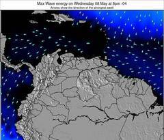
Previsioni Energia d'onda (Potenza): 12hrs

West Point Surf:
Wednesday, 15 July 2026, 14:25 Local time| Mercoledì 15 | ||||
| 11AM | 2PM | 5PM | 8PM | |
| Wave (m) | ||||
| Periodo (s) | - | - | - | - |
| Vento (km/h) | ||||
| Stato del vento | off | off | cross- off |
cross- off |
- /breaks/West-Point-Aruba/forecasts/latest
West Point Surf Guide
West Point in Aruba is an exposed point break that has reasonably consistent surf. Offshore winds blow from the east southeast. Waves just as likely from local windswells as from distant groundswells and the optimum swell angle is from the north northeast. An uncrowded break, even when it is working. Beware of - Urchins - Rips / undertow - Rocks.
West Point Spot Info
Type: Rating: Reliability: Todays Sea Temp*:  Point
Point 3
3fairly consistent 27.8°C*ocean temperature recorded from satelliteSurfing West Point:
The best conditions reported for surf at West Point occur when a North-northeast swell combines with an offshore wind direction from the East-southeast.
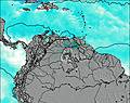
Previsioni Energia d'onda (Potenza): 12hrs
Utilizzare la scheda di navigazione in alto per visualizzare West Point temperatura del mare, West Point fotografie, West Point dettagliate previsioni onde, il vento e le previsioni meteo, West Point webcam, vento corrente da Aruba stazioni meteo e West Point previsioni marea. Il link Aruba mappe maree apre l'immagine grande, che mostra Aruba e dei mari circostanti. Queste mappe possono essere animate per mostrare le diverse componenti del moto ondoso, energia delle onde, periodo d'onda, altezza delle onde, insieme con le previsioni del vento e meteo, meteo corrente e osservazioni sullo stato del mare dal Aruba onda-boe, le navi passanti e stazioni meteo costiere. Ciascuna delle pagine di previsioni per questo surf break rappresenta uno strumento di wavefinder globale e regionale per individuare le migliori condizioni di surf nella zona intorno West Point.
West Point Surf:
Wednesday, 15 July 2026, 14:25 Local timeMercoledì 15 11AM 2PM 5PM 8PM Wave (m) Periodo (s) - - - - Vento (km/h) Stato del vento off off cross-
offcross-
off- /breaks/West-Point-Aruba/forecasts/latest
- /breaks/West-Point-Aruba/forecasts/latest/six_day
West Point Surf Guide
West Point in Aruba is an exposed point break that has reasonably consistent surf. Offshore winds blow from the east southeast. Waves just as likely from local windswells as from distant groundswells and the optimum swell angle is from the north northeast. An uncrowded break, even when it is working. Beware of - Urchins - Rips / undertow - Rocks.
West Point Spot Info
Type: Rating: Reliability: Todays Sea Temp*: Point3fairly consistent 27.8°C*ocean temperature recorded from satelliteSurfing West Point:
The best conditions reported for surf at West Point occur when a North-northeast swell combines with an offshore wind direction from the East-southeast.
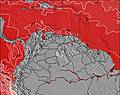
Previsioni Energia d'onda (Potenza): 12hrs
Utilizzare la scheda di navigazione in alto per visualizzare West Point temperatura del mare, West Point fotografie, West Point dettagliate previsioni onde, il vento e le previsioni meteo, West Point webcam, vento corrente da Aruba stazioni meteo e West Point previsioni marea. Il link Aruba mappe maree apre l'immagine grande, che mostra Aruba e dei mari circostanti. Queste mappe possono essere animate per mostrare le diverse componenti del moto ondoso, energia delle onde, periodo d'onda, altezza delle onde, insieme con le previsioni del vento e meteo, meteo corrente e osservazioni sullo stato del mare dal Aruba onda-boe, le navi passanti e stazioni meteo costiere. Ciascuna delle pagine di previsioni per questo surf break rappresenta uno strumento di wavefinder globale e regionale per individuare le migliori condizioni di surf nella zona intorno West Point.
West Point Surf:
Wednesday, 15 July 2026, 14:25 Local timeMercoledì 15 11AM 2PM 5PM 8PM Wave (m) Periodo (s) - - - - Vento (km/h) Stato del vento off off cross-
offcross-
off- /breaks/West-Point-Aruba/forecasts/latest
West Point Surf Guide
West Point in Aruba is an exposed point break that has reasonably consistent surf. Offshore winds blow from the east southeast. Waves just as likely from local windswells as from distant groundswells and the optimum swell angle is from the north northeast. An uncrowded break, even when it is working. Beware of - Urchins - Rips / undertow - Rocks.
West Point Spot Info
Type: Rating: Reliability: Todays Sea Temp*: Point3fairly consistent 27.8°C*ocean temperature recorded from satelliteSurfing West Point:
The best conditions reported for surf at West Point occur when a North-northeast swell combines with an offshore wind direction from the East-southeast.
Previsioni Energia d'onda (Potenza): 12hrs
Utilizzare la scheda di navigazione in alto per visualizzare West Point temperatura del mare, West Point fotografie, West Point dettagliate previsioni onde, il vento e le previsioni meteo, West Point webcam, vento corrente da Aruba stazioni meteo e West Point previsioni marea. Il link Aruba mappe maree apre l'immagine grande, che mostra Aruba e dei mari circostanti. Queste mappe possono essere animate per mostrare le diverse componenti del moto ondoso, energia delle onde, periodo d'onda, altezza delle onde, insieme con le previsioni del vento e meteo, meteo corrente e osservazioni sullo stato del mare dal Aruba onda-boe, le navi passanti e stazioni meteo costiere. Ciascuna delle pagine di previsioni per questo surf break rappresenta uno strumento di wavefinder globale e regionale per individuare le migliori condizioni di surf nella zona intorno West Point.
West Point Surf:
Wednesday, 15 July 2026, 14:25 Local timeMercoledì 15 11AM 2PM 5PM 8PM Wave (m) Periodo (s) - - - - Vento (km/h) Stato del vento off off cross-
offcross-
offTide Times:
Per Arasji, %{dist} %{km} da %{location}.
PROSSIMA È ALLE (ora locale) rimanente alta marea bassa marea West Point Tide Times and Tide Chart
Live Weather:
At Queen Beatrix Airport, 15 km from West Point.
strong winds from the E
(km/h)
Dry and partly cloudyAir temperature
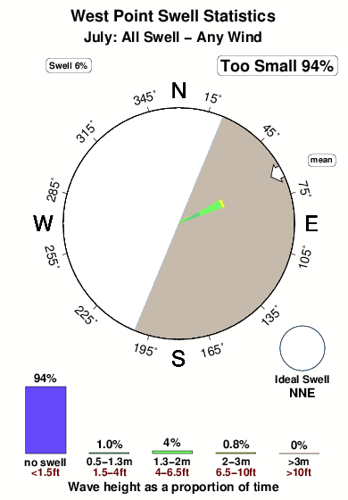
32°COverall West Point Surf Consistency and Wind Distribution in Luglio
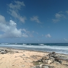
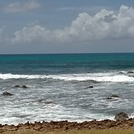
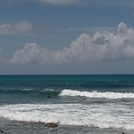
foto dall' album
Contorni: Strade e fiumi: seleziona un surf break dal menu 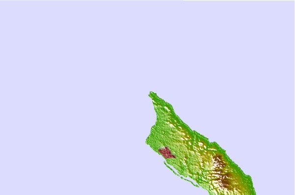
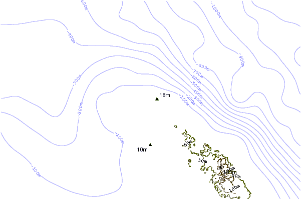
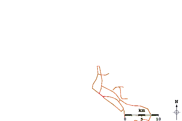
Utilizzare questa mappa sollievo per navigare Aruba surf breaks e stazioni di marea che si trovano nella zona diWest Point
Altri surf breaks più vicini al West Point:
(clicca sul nome del luogo per maggiori informazioni)- Closest località surf1 mi
- Second closest località surf1 mi
- Third closest località surf1 mi
- Fourth closest località surf3 mi
- Fifth closest località surf5 mi
Onda boe più vicina a West Point:
- Closest Onda boa433 mi
- Second closest Onda boa439 mi
- Third closest Onda boa483 mi
- Fourth closest Onda boa496 mi
- Fifth closest Onda boa515 mi
Stazioni di marea più vicina alla West Point:
- Closest marea stazioneArasji1 mi
- Second closest marea stazioneBabijn7 mi
- Third closest marea stazioneAngochi10 mi
- Fourth closest marea stazioneOranjestad10 mi
- Fifth closest marea stazioneAmuay61 mi
Airports
- The closest passenger airport to West Point is Reina Beatrix International (Oranjestad) Airport (AUA) in Aruba, 14 km (9 miles) away (directly).
- The second nearest airport to West Point is Josefa Camejo (Paraguana) Airport (LSP) in Venezuela, 94 km (58 miles) away.
- Third is Hato (Willemstad) Airport (CUR) in Antilles, 129 km (80 miles) away.
- Jose Leonardo Chirinos (Coro) Airport (CZE) in Venezuela is 140 km (87 miles) away.
- Flamingo (Kralendijk) Airport (BON) in Antilles is the fifth nearest airport to West Point and is 202 km (125 miles) away.
- /breaks/West-Point-Aruba/forecasts/latest


 Nearest