
Previsioni:

Previsione a breve terminePioggia abbondante (Totale 48mm), più pesante durante giovedì pomeriggio. Very mild (Max 19°C Sabato mattina, Min 14°C Venerdì notte). Vento sarà generalmente leggero. | ||||||||||||||||||||||||
Gio 16 | Venerdì 17 | Sabato 18 | Dom 19 | |||||||||||||||||||||
1 PM | 4 PM | 7 PM | 10 PM | 1 AM | 4 AM | 7 AM | 10 AM | 1 PM | 4 PM | 7 PM | 10 PM | 1 AM | 4 AM | 7 AM | 10 AM | 1 PM | 4 PM | 7 PM | 10 PM | 1 AM | 4 AM | 7 AM | 10 AM | |
Mappa dell'altezza del moto ondoso |  |  |  |  |  |  |  |  |  | 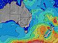 | ||||||||||||||
Onda Altezza (m) Direzione Periodo (s) | SSE 9 | SSE 9 | SSE 9 | SSE 9 | SSE 8 | SSE 8 | SSE 8 | SE 8 | SSE 8 | SSE 8 | SSE 8 | SSE 8 | SSE 8 | SSE 8 | SSE 8 | SSE 8 | SSE 8 | SSE 8 | ESE 10 | ESE 10 | ESE 11 | ESE 11 | ESE 11 | SE 10 |
Grafico delle onde | ||||||||||||||||||||||||
2174 | 2214 | 1895 | 1447 | 1099 | 861 | 700 | 665 | 496 | 494 | 645 | 791 | 762 | 762 | 762 | 923 | 1415 | 1408 | 1522 | 2130 | 3030 | 2523 | 2031 | 3504 | |
Vento (km/h) | ||||||||||||||||||||||||
Stato del vento onshore cross-onshore cross-shore cross-offshore offshore piatto | cross-off | cross-off | cross-off | cross-off | cross-off | cross-off | cross-off | cross-off | cross-off | cross-off | cross-off | cross-off | off | off | off | off | cross-off | cross-off | off | off | cross-off | cross-off | cross-off | cross-off |
Alta Marea | 10:07PM1.88m | 10:28AM1.26m | 10:48PM1.77m | 11:15AM1.26m | 11:29PM1.62m | |||||||||||||||||||
Basso Marea | 3:25PM0.13m | 4:40AM0.19m | 4:12PM0.20m | 5:21AM0.23m | 4:59PM0.30m | 6:01AM0.27m | ||||||||||||||||||
— | — | — | — | — | 6:35 | — | — | — | — | — | — | — | 6:35 | — | — | — | — | — | — | — | 6:35 | — | — | |
— | 5:06 | — | — | — | — | — | — | — | 5:07 | — | — | — | — | — | — | — | 5:07 | — | — | — | — | — | 5:07 | |
mm | 3 | 2 | 8 | 3 | 3 | 3 | 3 | 2 | 2 | 3 | 3 | 2 | 2 | 1 | 1 | — | — | — | — | — | 1 | 2 | 2 | 2 |
Temp. °C | 17 | 16 | 17 | 17 | 17 | 17 | 16 | 18 | 18 | 17 | 17 | 16 | 14 | 14 | 15 | 15 | 19 | 18 | 18 | 17 | 17 | 17 | 18 | 18 |
Gelo °C | 12 | 11 | 13 | 13 | 14 | 15 | 14 | 16 | 15 | 14 | 14 | 13 | 11 | 11 | 12 | 11 | 14 | 13 | 13 | 12 | 13 | 13 | 14 | 15 |
Onda 1 Altezza (m) Direzione Periodo (s) | — | — | NE 8 | NE 8 | NE 8 | NE 8 | NE 8 | NE 8 | E 6 | ENE 6 | SE 18 | SE 16 | S 16 | S 15 | S 15 | S 22 | SE 22 | ESE 10 | ESE 10 | ESE 10 | ESE 11 | ESE 11 | ESE 11 | S 24 |
— | — | 3 | 11 | 11 | 11 | 10 | 9 | 46 | 64 | 12 | 10 | 19 | 17 | 17 | 10 | 19 | 821 | 1522 | 2130 | 3030 | 2523 | 2031 | 11 | |
Onda 2 Altezza (m) Direzione Periodo (s) | — | — | — | S 19 | S 19 | SE 18 | SE 18 | SE 18 | NE 7 | SE 18 | S 18 | — | — | — | — | — | — | E 20 | SE 22 | SE 21 | SSE 21 | SSE 21 | — | S 24 |
— | — | — | 7 | 7 | 13 | 13 | 13 | 8 | 13 | 56 | — | — | — | — | — | — | 8 | 18 | 18 | 44 | 43 | — | 11 | |
Onda 3 Altezza (m) Direzione Periodo (s) | — | — | — | — | — | — | — | — | SSE 19 | — | — | — | — | — | — | — | — | — | — | — | — | — | — | — |
— | — | — | — | — | — | — | — | 34 | — | — | — | — | — | — | — | — | — | — | — | — | — | — | — | |
onde vento Altezza (m) Direzione Periodo (s) | SSE 9 | SSE 9 | SSE 9 | SSE 9 | SSE 8 | SSE 8 | SSE 8 | SE 8 | SSE 8 | SSE 8 | SSE 8 | SSE 8 | SSE 8 | SSE 8 | SSE 8 | SSE 8 | SSE 8 | SSE 8 | S 8 | S 9 | S 8 | S 8 | SSE 8 | SE 10 |
2174 | 2214 | 1895 | 1447 | 1099 | 861 | 700 | 665 | 496 | 494 | 645 | 791 | 762 | 762 | 762 | 923 | 1415 | 1408 | 1326 | 1228 | 912 | 921 | 1118 | 3504 | |
Il più vicino Offshore or Glassy | ||||||||||||||||||||||||
Distanza (km) | 41 | 41 | 46 | 238 | 417 | 417 | 397 | 41 | 397 | 41 | 41 | 41 | 516 | 581 | 397 | 46 | 46 | 211 | 213 | 605 | 605 | 728 | 695 | 605 |
Migliori previsioni per le condizioni d'onda in North Coast - New South Wales | ||||||||||||||||||||||||
Migliori previsioni per le condizioni d'onda in Australia | ||||||||||||||||||||||||
Trova Onde Globale | ||||||||||||||||||||||||
- Map Icons:
 Break
Break Live Wave Height (m)
 Live Wind Speed (km/h)
 Surf Rating (10 Max)
 Ocean Swells (m)
- Wind Speed (km/h)
Widget Free Surf-Forecast.com per il tuo sito
La relazione di surf / widget meteo è disponibile qui sotto per incorporare su siti esterni a titolo gratuito e fornisce una sintesi delle nostre Brunswick Heads North previsione surf. Basta prendere il frammento di codice html da noi fornito e copiarlo nel proprio sito. È possibile scegliere la lingua preferita e unità metriche / imperiali per il feed delle previsioni surf per soddisfare le esigenze degli utenti del vostro sito .... Clicca qui per ottenere il codice.
 Nearest