
Previsioni:

Previsione a breve terminePioggia abbondante (Totale 36mm), più pesante durante martedì mattina. Very mild (Max 16°C giovedì pomeriggio, Min 12°C martedì mattina). Vento sarà generalmente leggero. | ||||||||||||||||||||||||
Martedì 21 | Mercoledì 22 | Giovedì 23 | ||||||||||||||||||||||
2 AM | 5 AM | 8 AM | 11 AM | 2 PM | 5 PM | 8 PM | 11 PM | 2 AM | 5 AM | 8 AM | 11 AM | 2 PM | 5 PM | 8 PM | 11 PM | 2 AM | 5 AM | 8 AM | 11 AM | 2 PM | 5 PM | 8 PM | 11 PM | |
Mappa dell'altezza del moto ondoso |  | 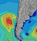 |  |  | 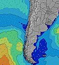 |  |  | 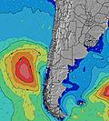 |  | |||||||||||||||
Onda Altezza (m) Direzione Periodo (s) | W 11 | W 11 | W 11 | NW 7 | NW 8 | NW 8 | NW 8 | WNW 9 | WNW 9 | WNW 9 | WNW 10 | W 10 | W 10 | W 10 | W 10 | W 10 | W 10 | W 10 | W 10 | W 9 | W 9 | W 9 | W 9 | WSW 12 |
Grafico delle onde | ||||||||||||||||||||||||
157 | 121 | 119 | 115 | 147 | 215 | 143 | 111 | 274 | 367 | 512 | 608 | 682 | 615 | 625 | 459 | 379 | 320 | 262 | 207 | 168 | 173 | 212 | 861 | |
Vento (km/h) | ||||||||||||||||||||||||
Stato del vento onshore cross-onshore cross-shore cross-offshore offshore piatto | cross-off | cross-off | cross-off | off | off | cross-off | cross-off | cross-off | cross-off | cross-on | glassy | glassy | cross-on | glassy | glassy | glassy | glassy | glassy | glassy | cross-off | glassy | cross-on | cross | cross |
Alta Marea | 3:37AM1.07m | 3:34PM0.94m | 4:37AM1.08m | 4:40PM0.82m | 5:42AM1.10m | 6:04PM0.75m | ||||||||||||||||||
Basso Marea | 9:50AM0.42m | 9:54PM0.31m | 11:13AM0.46m | 10:46PM0.38m | 12:39PM0.44m | |||||||||||||||||||
— | 7:41 | — | — | — | — | — | — | — | 7:41 | — | — | — | — | — | — | — | 7:41 | — | — | — | — | — | — | |
— | — | — | — | — | 6:00 | — | — | — | — | — | — | — | 6:01 | — | — | — | — | — | — | — | 6:01 | — | — | |
mm | 5 | 9 | 16 | 11 | 6 | — | — | — | — | — | — | — | — | — | — | — | — | — | — | — | — | — | 2 | 1 |
Temp. °C | 12 | 11 | 12 | 12 | 13 | 14 | 14 | 14 | 15 | 14 | 14 | 15 | 15 | 14 | 15 | 14 | 14 | 14 | 14 | 14 | 16 | 13 | 13 | 14 |
Gelo °C | 8 | 8 | 8 | 8 | 9 | 11 | 11 | 11 | 12 | 12 | 12 | 13 | 12 | 13 | 14 | 13 | 13 | 13 | 13 | 11 | 15 | 11 | 11 | 12 |
Onda 1 Altezza (m) Direzione Periodo (s) | W 11 | W 11 | NW 7 | NW 7 | NW 8 | NW 8 | NW 8 | WNW 9 | WNW 9 | WNW 9 | WNW 10 | W 10 | W 10 | W 10 | W 10 | W 10 | W 10 | W 10 | W 10 | W 9 | W 9 | W 9 | W 9 | WSW 12 |
157 | 121 | 46 | 115 | 147 | 215 | 143 | 111 | 274 | 367 | 512 | 608 | 682 | 615 | 625 | 459 | 379 | 320 | 262 | 207 | 168 | 173 | 212 | 861 | |
Onda 2 Altezza (m) Direzione Periodo (s) | SW 11 | NNW 6 | W 11 | W 11 | W 11 | W 11 | W 10 | NNW 7 | SSW 10 | SSW 10 | SSW 10 | SW 13 | SW 13 | SW 12 | SW 12 | SW 11 | SW 11 | SW 11 | SW 11 | SW 11 | SSW 11 | WSW 19 | WSW 12 | WSW 18 |
55 | 16 | 119 | 86 | 83 | 82 | 78 | 66 | 10 | 10 | 11 | 28 | 42 | 37 | 39 | 31 | 31 | 30 | 30 | 18 | 11 | 37 | 162 | 32 | |
Onda 3 Altezza (m) Direzione Periodo (s) | NNW 7 | SW 10 | SW 10 | SW 10 | SW 10 | SW 10 | WNW 9 | W 10 | SW 15 | SW 15 | WSW 14 | WSW 24 | WSW 24 | WSW 23 | WSW 22 | SW 13 | WSW 22 | WSW 21 | SW 20 | WSW 20 | WSW 20 | SSW 10 | WSW 19 | W 19 |
11 | 28 | 27 | 27 | 16 | 16 | 16 | 77 | 9 | 9 | 19 | 56 | 55 | 51 | 46 | 28 | 45 | 43 | 60 | 37 | 37 | 10 | 35 | 29 | |
onde vento Altezza (m) Direzione Periodo (s) | ENE 3 | ENE 3 | NE 2 | NE 3 | NE 3 | ENE 3 | — | — | — | — | — | — | — | — | — | — | — | — | — | — | — | WSW 2 | — | — |
3 | 2 | 2 | 4 | 5 | 1 | — | — | — | — | — | — | — | — | — | — | — | — | — | — | — | 1 | — | — | |
Il più vicino Offshore or Glassy | ||||||||||||||||||||||||
Distanza (km) | 11 | 0 | 39 | 0 | 0 | 0 | 0 | 0 | 0 | 11 | 0 | 0 | 106 | 0 | 0 | 0 | 0 | 0 | 0 | 0 | 0 | 521 | 11 | 11 |
Migliori previsioni per le condizioni d'onda in Santiago | ||||||||||||||||||||||||
Migliori previsioni per le condizioni d'onda in Chile | ||||||||||||||||||||||||
Trova Onde Globale | ||||||||||||||||||||||||
- Map Icons:
 Break
Break Live Wave Height (m)
 Live Wind Speed (km/h)
 Surf Rating (10 Max)
 Ocean Swells (m)
- Wind Speed (km/h)
Widget Free Surf-Forecast.com per il tuo sito
La relazione di surf / widget meteo è disponibile qui sotto per incorporare su siti esterni a titolo gratuito e fornisce una sintesi delle nostre Cachagua previsione surf. Basta prendere il frammento di codice html da noi fornito e copiarlo nel proprio sito. È possibile scegliere la lingua preferita e unità metriche / imperiali per il feed delle previsioni surf per soddisfare le esigenze degli utenti del vostro sito .... Clicca qui per ottenere il codice.
 Nearest