
Previsioni:

Previsione a breve termineper lo più asciutto. Warm (Max 28°C Sabato pomeriggio, Min 26°C giovedì mattina). Principalmente venti freschi. | ||||||||||||||||||||||||
Giovedì 16 | Venerdì 17 | Sabato 18 | ||||||||||||||||||||||
2 AM | 5 AM | 8 AM | 11 AM | 2 PM | 5 PM | 8 PM | 11 PM | 2 AM | 5 AM | 8 AM | 11 AM | 2 PM | 5 PM | 8 PM | 11 PM | 2 AM | 5 AM | 8 AM | 11 AM | 2 PM | 5 PM | 8 PM | 11 PM | |
Mappa dell'altezza del moto ondoso |  | 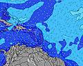 |  |  |  |  |  |  |  | |||||||||||||||
Onda Altezza (m) Direzione Periodo (s) | E 4 | ESE 5 | ESE 5 | ESE 5 | ESE 5 | ESE 6 | ESE 6 | ESE 6 | ESE 6 | ESE 6 | ESE 6 | ESE 6 | ESE 6 | E 6 | E 6 | E 6 | ESE 6 | ESE 6 | ESE 6 | ESE 6 | ESE 6 | ESE 7 | E 7 | E 7 |
Grafico delle onde | ||||||||||||||||||||||||
41 | 56 | 51 | 49 | 60 | 67 | 89 | 84 | 67 | 67 | 69 | 69 | 83 | 82 | 98 | 91 | 89 | 92 | 98 | 113 | 139 | 157 | 161 | 166 | |
Vento (km/h) | ||||||||||||||||||||||||
Stato del vento onshore cross-onshore cross-shore cross-offshore offshore piatto | cross-on | cross-on | cross-on | cross-on | cross-on | cross-on | cross-on | cross-on | cross-on | cross-on | cross-on | cross-on | cross-on | cross-on | cross-on | cross-on | cross-on | cross-on | cross-on | cross-on | cross-on | cross-on | cross-on | cross-on |
Alta Marea | 9:36AM0.34m | 10:46PM0.53m | 10:41AM0.37m | 11:27PM0.49m | 11:44AM0.39m | |||||||||||||||||||
Basso Marea | 4:33AM0.17m | 3:39PM0.03m | 5:13AM0.16m | 4:39PM0.08m | 5:52AM0.14m | 5:41PM0.13m | ||||||||||||||||||
— | 5:50 | — | — | — | — | — | — | — | 5:50 | — | — | — | — | — | — | — | 5:50 | — | — | — | — | — | — | |
— | — | — | — | — | 6:58 | — | — | — | — | — | — | — | 6:58 | — | — | — | — | — | — | — | 6:57 | — | — | |
mm | — | — | — | — | — | — | — | — | — | — | — | — | — | — | — | — | — | — | — | — | — | — | — | — |
Temp. °C | 27 | 27 | 27 | 26 | 27 | 27 | 27 | 27 | 27 | 27 | 27 | 27 | 27 | 27 | 27 | 27 | 26 | 26 | 27 | 27 | 28 | 27 | 27 | 27 |
Gelo °C | 25 | 26 | 27 | 25 | 26 | 26 | 25 | 26 | 26 | 26 | 26 | 26 | 27 | 26 | 26 | 26 | 25 | 25 | 25 | 26 | 27 | 25 | 25 | 26 |
Onda 1 Altezza (m) Direzione Periodo (s) | N 9 | N 8 | N 8 | N 8 | N 8 | N 8 | N 7 | NNE 7 | N 7 | N 7 | N 7 | NE 8 | NNE 8 | SSE 5 | NNE 8 | NNE 7 | NNE 7 | NNE 7 | NE 9 | NE 8 | NE 9 | NE 8 | NE 8 | N 10 |
1 | 6 | 5 | 5 | 5 | 4 | 4 | 5 | 4 | 4 | 4 | 3 | 6 | 5 | 11 | 5 | 5 | 5 | 12 | 11 | 12 | 18 | 17 | 2 | |
Onda 2 Altezza (m) Direzione Periodo (s) | N 7 | NW 7 | NW 6 | N 6 | N 6 | — | N 9 | NE 9 | NE 8 | NE 8 | NE 8 | N 7 | NE 10 | NNE 8 | SSE 5 | NNE 9 | NNE 9 | NNE 9 | NNE 9 | — | NNE 7 | N 11 | N 11 | N 10 |
1 | 2 | 2 | 1 | 1 | — | 1 | 3 | 3 | 3 | 3 | 4 | 4 | 12 | 6 | 8 | 8 | 8 | 8 | — | 4 | 2 | 2 | 2 | |
Onda 3 Altezza (m) Direzione Periodo (s) | N 9 | N 9 | N 6 | — | — | — | N 6 | — | — | N 7 | N 7 | NNE 8 | NE 8 | NE 10 | NNE 10 | SE 6 | — | — | — | — | — | N 11 | — | — |
2 | 2 | 1 | — | — | — | 1 | — | — | 1 | 1 | 7 | 3 | 4 | 9 | 1 | — | — | — | — | — | 3 | — | — | |
onde vento Altezza (m) Direzione Periodo (s) | E 4 | ESE 5 | ESE 5 | ESE 5 | ESE 5 | ESE 6 | ESE 6 | ESE 6 | ESE 6 | ESE 6 | ESE 6 | ESE 6 | ESE 6 | E 6 | E 6 | E 6 | ESE 6 | ESE 6 | ESE 6 | ESE 6 | ESE 6 | ESE 7 | E 7 | E 7 |
41 | 56 | 51 | 49 | 60 | 67 | 89 | 84 | 67 | 67 | 69 | 69 | 83 | 82 | 98 | 91 | 89 | 92 | 98 | 113 | 139 | 157 | 161 | 166 | |
Il più vicino Offshore or Glassy | ||||||||||||||||||||||||
Distanza (km) | 257 | 259 | 571 | 539 | 395 | 809 | 909 | 563 | 156 | 172 | 563 | 153 | 153 | 773 | 264 | 638 | 490 | 505 | 563 | 909 | 199 | 395 | 395 | 563 |
Migliori previsioni per le condizioni d'onda in Tortola - BVI | ||||||||||||||||||||||||
Migliori previsioni per le condizioni d'onda in British Virgin Islands | ||||||||||||||||||||||||
Trova Onde Globale | ||||||||||||||||||||||||
- Map Icons:
 Break
Break Live Wave Height (m)
 Live Wind Speed (km/h)
 Surf Rating (10 Max)
 Ocean Swells (m)
- Wind Speed (km/h)
Widget Free Surf-Forecast.com per il tuo sito
La relazione di surf / widget meteo è disponibile qui sotto per incorporare su siti esterni a titolo gratuito e fornisce una sintesi delle nostre Carot Bay previsione surf. Basta prendere il frammento di codice html da noi fornito e copiarlo nel proprio sito. È possibile scegliere la lingua preferita e unità metriche / imperiali per il feed delle previsioni surf per soddisfare le esigenze degli utenti del vostro sito .... Clicca qui per ottenere il codice.
 Nearest