
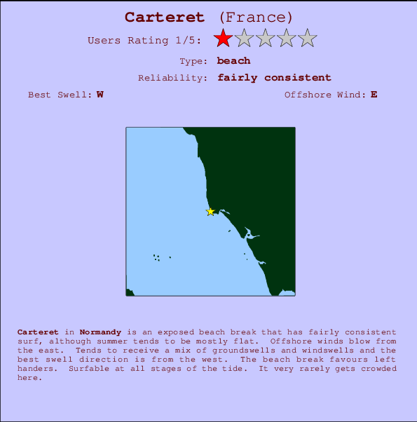
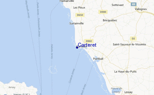
Carteret Surf Guide
Carteret in Normandy is an exposed beach break that has fairly consistent surf, although summer tends to be mostly flat. Ideal winds are from the east. Tends to receive a mix of groundswells and windswells and the best swell direction is from the west. The beach breaks offer lefts and rights. Good surf at all stages of the tide. Rarely crowded here.
Carteret Spot Info
| Type: | Rating: | Reliability: | Todays Sea Temp*: |
|---|---|---|---|
| fairly consistent | 19.5°C*ocean temperature recorded from satellite |
Surfing Carteret:
The best conditions reported for surf at Carteret occur when a West swell combines with an offshore wind direction from the East.
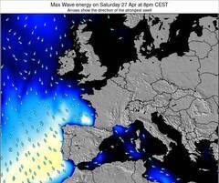
Previsioni Energia d'onda (Potenza): 12hrs


Carteret Surf:
Saturday, 18 July 2026, 06:10 Local time| Sabato 18 | ||||
| 5AM | 8AM | 11AM | 2PM | |
| Wave (m) | ||||
| Periodo (s) | 8 | 8 | 8 | 8 |
| Vento (km/h) | ||||
| Stato del vento | cross- on |
cross- on |
on | on |
- /breaks/Carteret/forecasts/latest
Carteret Surf Guide
Carteret in Normandy is an exposed beach break that has fairly consistent surf, although summer tends to be mostly flat. Ideal winds are from the east. Tends to receive a mix of groundswells and windswells and the best swell direction is from the west. The beach breaks offer lefts and rights. Good surf at all stages of the tide. Rarely crowded here.
Carteret Spot Info
Type: Rating: Reliability: Todays Sea Temp*:  Beach
Beach 1
1fairly consistent 19.5°C*ocean temperature recorded from satelliteSurfing Carteret:
The best conditions reported for surf at Carteret occur when a West swell combines with an offshore wind direction from the East.
Previsioni Energia d'onda (Potenza): 12hrs
Utilizzare la scheda di navigazione in alto per visualizzare Carteret temperatura del mare, Carteret fotografie, Carteret dettagliate previsioni onde, il vento e le previsioni meteo, Carteret webcam, vento corrente da Normandy stazioni meteo e Carteret previsioni marea. Il link France mappe maree apre l'immagine grande, che mostra France e dei mari circostanti. Queste mappe possono essere animate per mostrare le diverse componenti del moto ondoso, energia delle onde, periodo d'onda, altezza delle onde, insieme con le previsioni del vento e meteo, meteo corrente e osservazioni sullo stato del mare dal France onda-boe, le navi passanti e stazioni meteo costiere. Ciascuna delle pagine di previsioni per questo surf break rappresenta uno strumento di wavefinder globale e regionale per individuare le migliori condizioni di surf nella zona intorno Carteret.
Carteret Surf:
Saturday, 18 July 2026, 06:10 Local timeSabato 18 5AM 8AM 11AM 2PM Wave (m) Periodo (s) 8 8 8 8 Vento (km/h) Stato del vento cross-
oncross-
onon on - /breaks/Carteret/forecasts/latest
- /breaks/Carteret/forecasts/latest/six_day
Carteret Surf Guide
Carteret in Normandy is an exposed beach break that has fairly consistent surf, although summer tends to be mostly flat. Ideal winds are from the east. Tends to receive a mix of groundswells and windswells and the best swell direction is from the west. The beach breaks offer lefts and rights. Good surf at all stages of the tide. Rarely crowded here.
Carteret Spot Info
Type: Rating: Reliability: Todays Sea Temp*: Beach1fairly consistent 19.5°C*ocean temperature recorded from satelliteSurfing Carteret:
The best conditions reported for surf at Carteret occur when a West swell combines with an offshore wind direction from the East.
Previsioni Energia d'onda (Potenza): 12hrs
Utilizzare la scheda di navigazione in alto per visualizzare Carteret temperatura del mare, Carteret fotografie, Carteret dettagliate previsioni onde, il vento e le previsioni meteo, Carteret webcam, vento corrente da Normandy stazioni meteo e Carteret previsioni marea. Il link France mappe maree apre l'immagine grande, che mostra France e dei mari circostanti. Queste mappe possono essere animate per mostrare le diverse componenti del moto ondoso, energia delle onde, periodo d'onda, altezza delle onde, insieme con le previsioni del vento e meteo, meteo corrente e osservazioni sullo stato del mare dal France onda-boe, le navi passanti e stazioni meteo costiere. Ciascuna delle pagine di previsioni per questo surf break rappresenta uno strumento di wavefinder globale e regionale per individuare le migliori condizioni di surf nella zona intorno Carteret.
Carteret Surf:
Saturday, 18 July 2026, 06:10 Local timeSabato 18 5AM 8AM 11AM 2PM Wave (m) Periodo (s) 8 8 8 8 Vento (km/h) Stato del vento cross-
oncross-
onon on - /breaks/Carteret/forecasts/latest
Carteret Surf Guide
Carteret in Normandy is an exposed beach break that has fairly consistent surf, although summer tends to be mostly flat. Ideal winds are from the east. Tends to receive a mix of groundswells and windswells and the best swell direction is from the west. The beach breaks offer lefts and rights. Good surf at all stages of the tide. Rarely crowded here.
Carteret Spot Info
Type: Rating: Reliability: Todays Sea Temp*: Beach1fairly consistent 19.5°C*ocean temperature recorded from satelliteSurfing Carteret:
The best conditions reported for surf at Carteret occur when a West swell combines with an offshore wind direction from the East.
Previsioni Energia d'onda (Potenza): 12hrs
Utilizzare la scheda di navigazione in alto per visualizzare Carteret temperatura del mare, Carteret fotografie, Carteret dettagliate previsioni onde, il vento e le previsioni meteo, Carteret webcam, vento corrente da Normandy stazioni meteo e Carteret previsioni marea. Il link France mappe maree apre l'immagine grande, che mostra France e dei mari circostanti. Queste mappe possono essere animate per mostrare le diverse componenti del moto ondoso, energia delle onde, periodo d'onda, altezza delle onde, insieme con le previsioni del vento e meteo, meteo corrente e osservazioni sullo stato del mare dal France onda-boe, le navi passanti e stazioni meteo costiere. Ciascuna delle pagine di previsioni per questo surf break rappresenta uno strumento di wavefinder globale e regionale per individuare le migliori condizioni di surf nella zona intorno Carteret.
Carteret Surf:
Saturday, 18 July 2026, 06:10 Local timeSabato 18 5AM 8AM 11AM 2PM Wave (m) Periodo (s) 8 8 8 8 Vento (km/h) Stato del vento cross-
oncross-
onon on Tide Times:
Per Baubigny, %{dist} %{km} da %{location}.
PROSSIMA È ALLE (ora locale) rimanente alta marea bassa marea Carteret Tide Times and Tide Chart
Live Weather:
At Vauville, 28 km from Carteret.
light winds from the WSW
(km/h)Air temperature
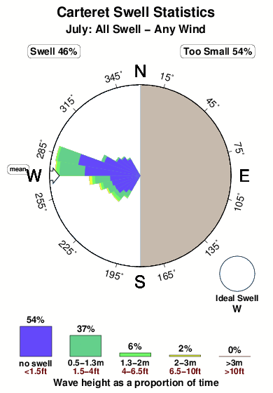
16.0°COverall Carteret Surf Consistency and Wind Distribution in Luglio
foto dall' album
Contorni: Strade e fiumi: seleziona un surf break dal menu 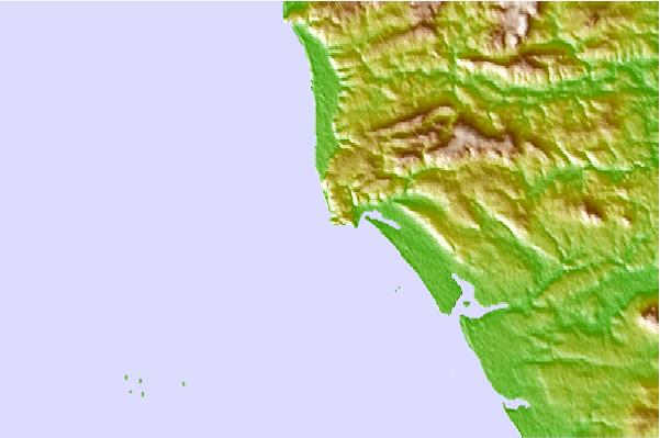
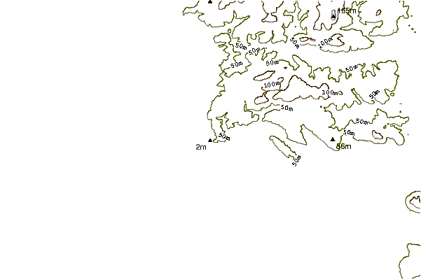
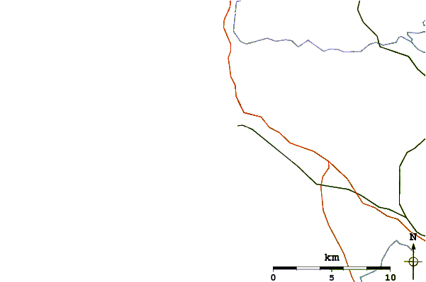
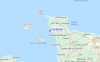
Utilizzare questa mappa sollievo per navigare Normandy surf breaks e stazioni di marea che si trovano nella zona diCarteret
Altri surf breaks più vicini al Carteret:
(clicca sul nome del luogo per maggiori informazioni)- Closest località surf4 mi
- Second closest località surf7 mi
- Third closest località surf7 mi
- Fourth closest località surf8 mi
- Fifth closest località surf9 mi
Onda boe più vicina a Carteret:
- Closest Onda boa61 mi
- Second closest Onda boa89 mi
- Third closest Onda boa91 mi
- Fourth closest Onda boa91 mi
- Fifth closest Onda boa93 mi
Stazioni di marea più vicina alla Carteret:
- Closest marea stazioneOcteville18 mi
- Second closest marea stazioneSaint Helier, Jersey, Channel Islands19 mi
- Third closest marea stazioneQuerqueville21 mi
- Fourth closest marea stazioneCherbourg21 mi
- Fifth closest marea stazioneTourlaville21 mi
Airports
- The closest passenger airport to Carteret is Jersey Airport (JER) in England, 34 km (21 miles) away (directly).
- The second nearest airport to Carteret is Maupertus (Cherbourg) Airport (CER) in France, 39 km (24 miles) away.
- Third is Guernsey Airport (GCI) in Guernsey Isld., 58 km (36 miles) away.
- Pleurtuit (Dinard) Airport (DNR) in France is 90 km (56 miles) away.
- Carpiquet (Caen) Airport (CFR), also in France is the fifth nearest airport to Carteret and is 101 km (63 miles) away.
- /breaks/Carteret/forecasts/latest


 Nearest