
Previsioni:

Previsione a breve termineQualche pioggerella, più pesante durante lunedì pomeriggio. Very mild (Max 15°C Domenica mattina, Min 12°C Venerdì notte). Vento sarà generalmente leggero. | ||||||||||||||||||
Ven 17 | Sabato 18 | Domenica 19 | ||||||||||||||||
7 PM | 10 PM | 1 AM | 4 AM | 7 AM | 10 AM | 1 PM | 4 PM | 7 PM | 10 PM | 1 AM | 4 AM | 7 AM | 10 AM | 1 PM | 4 PM | 7 PM | 10 PM | |
Mappa dell'altezza del moto ondoso |  |  |  |  |  | 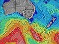 |  | |||||||||||
Onda Altezza (m) Direzione Periodo (s) | SSW 16 | SSW 15 | SSW 15 | SSW 14 | SSW 14 | SSW 13 | SSW 12 | SSW 12 | SSW 12 | S 12 | S 12 | S 12 | S 11 | S 11 | S 11 | S 11 | S 11 | S 11 |
Grafico delle onde | ||||||||||||||||||
827 | 621 | 573 | 465 | 452 | 440 | 490 | 482 | 519 | 425 | 409 | 333 | 305 | 240 | 191 | 151 | 114 | 110 | |
Vento (km/h) | ||||||||||||||||||
Stato del vento onshore cross-onshore cross-shore cross-offshore offshore piatto | cross-off | cross-off | cross-off | cross-off | cross-off | cross-off | off | off | cross-off | cross-off | cross-off | cross-off | cross-off | cross-off | cross-off | cross | cross | cross-off |
Alta Marea | 8:36PM1.04m | 11:50AM0.75m | 9:31PM0.90m | 12:10PM0.80m | ||||||||||||||
Basso Marea | 4:30AM0.17m | 3:48PM0.66m | 5:00AM0.28m | 5:27PM0.62m | ||||||||||||||
— | — | — | — | 7:37 | — | — | — | — | — | — | — | 7:35 | — | — | — | — | — | |
— | — | — | — | — | — | — | 4:55 | — | — | — | — | — | — | — | 4:57 | — | — | |
mm | — | — | — | — | — | — | — | — | — | — | — | — | — | — | — | — | — | — |
Temp. °C | 13 | 13 | 12 | 13 | 13 | 13 | 14 | 14 | 13 | 13 | 13 | 13 | 13 | 13 | 14 | 15 | 15 | 14 |
Gelo °C | 8 | 7 | 5 | 7 | 8 | 8 | 11 | 11 | 11 | 10 | 10 | 10 | 10 | 10 | 12 | 12 | 12 | 11 |
Onda 1 Altezza (m) Direzione Periodo (s) | SSW 16 | SSW 15 | SSW 15 | SSW 14 | SSW 14 | SSW 13 | SSW 12 | SSW 12 | SSW 12 | S 12 | S 12 | S 12 | S 11 | S 11 | S 11 | S 11 | S 11 | S 11 |
827 | 621 | 573 | 465 | 452 | 440 | 490 | 482 | 519 | 425 | 409 | 333 | 305 | 240 | 191 | 151 | 114 | 110 | |
Onda 2 Altezza (m) Direzione Periodo (s) | SE 18 | SE 18 | SE 18 | SSE 18 | S 17 | S 17 | S 16 | SSE 16 | SE 17 | SE 17 | SE 17 | SE 16 | SE 16 | SE 16 | SE 16 | SE 16 | ESE 15 | ESE 15 |
13 | 13 | 12 | 103 | 149 | 140 | 135 | 86 | 46 | 46 | 74 | 69 | 67 | 65 | 64 | 62 | 92 | 87 | |
Onda 3 Altezza (m) Direzione Periodo (s) | E 14 | E 14 | — | ESE 17 | ESE 17 | ESE 17 | ESE 17 | ESE 17 | S 16 | SE 17 | S 22 | S 16 | S 16 | S 20 | S 15 | SSW 18 | SSW 18 | SSW 18 |
4 | 4 | — | 30 | 29 | 29 | 29 | 28 | 20 | 75 | 9 | 5 | 20 | 30 | 18 | 65 | 63 | 63 | |
onde vento Altezza (m) Direzione Periodo (s) | — | NW 2 | WNW 3 | NW 3 | NW 3 | NW 3 | NW 3 | WSW 13 | — | — | — | — | — | — | — | — | — | NNE 4 |
— | 1 | 3 | 5 | 5 | 5 | 2 | 1648 | — | — | — | — | — | — | — | — | — | 1 | |
Il più vicino Offshore or Glassy | ||||||||||||||||||
Distanza (km) | 15 | 15 | 15 | 15 | 15 | 15 | 15 | 13 | 13 | 13 | 13 | 13 | 13 | 13 | 13 | 13 | 13 | 13 |
Migliori previsioni per le condizioni d'onda in East Coast of Tasmania | ||||||||||||||||||
Migliori previsioni per le condizioni d'onda in Australia | ||||||||||||||||||
Trova Onde Globale | ||||||||||||||||||
- Map Icons:
 Break
Break Live Wave Height (m)
 Live Wind Speed (km/h)
 Surf Rating (10 Max)
 Ocean Swells (m)
- Wind Speed (km/h)
Widget Free Surf-Forecast.com per il tuo sito
La relazione di surf / widget meteo è disponibile qui sotto per incorporare su siti esterni a titolo gratuito e fornisce una sintesi delle nostre Bruny Island - Coal Point previsione surf. Basta prendere il frammento di codice html da noi fornito e copiarlo nel proprio sito. È possibile scegliere la lingua preferita e unità metriche / imperiali per il feed delle previsioni surf per soddisfare le esigenze degli utenti del vostro sito .... Clicca qui per ottenere il codice.
 Nearest