
Previsioni:

Previsione a breve terminepioggia leggera (Totale 7mm), per lo più che cade Venerdì pomeriggio. Very mild (Max 19°C Venerdì mattina, Min 10°C Domenica mattina). Venti decrescenti (venti freschi da ONO Venerdì pomeriggio, venti deboli da SE per sabato notte). | |||||||||||||||||||||
Gio 30 | Venerdì 31 | Sabato 1 | |||||||||||||||||||
11 AM | 2 PM | 5 PM | 8 PM | 11 PM | 2 AM | 5 AM | 8 AM | 11 AM | 2 PM | 5 PM | 8 PM | 11 PM | 2 AM | 5 AM | 8 AM | 11 AM | 2 PM | 5 PM | 8 PM | 11 PM | |
Mappa dell'altezza del moto ondoso |  |  | 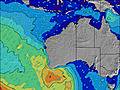 | 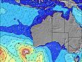 |  |  | 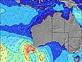 |  | |||||||||||||
Onda Altezza (m) Direzione Periodo (s) | SW 15 | SW 14 | SW 15 | SW 18 | SW 18 | SW 17 | SW 16 | SW 16 | SW 17 | SW 16 | SW 16 | SW 16 | SW 16 | SW 15 | SW 15 | SW 15 | SW 14 | SW 16 | SW 16 | SW 15 | SW 14 |
Grafico delle onde | |||||||||||||||||||||
1308 | 1273 | 1413 | 1516 | 3948 | 3814 | 3634 | 4899 | 7029 | 7786 | 7329 | 8940 | 8321 | 7656 | 6515 | 5889 | 6019 | 8700 | 10594 | 8805 | 7429 | |
Vento (km/h) | |||||||||||||||||||||
Stato del vento onshore cross-onshore cross-shore cross-offshore offshore piatto | cross-off | cross | cross-on | cross | cross | cross | cross | cross | cross | cross-on | on | on | on | cross-on | cross-on | cross-on | cross-on | cross-on | cross-on | cross | cross |
Alta Marea | 10:39AM0.95m | 11:27PM0.44m | 11:15AM0.91m | 11:17PM0.45m | 11:54AM0.84m | ||||||||||||||||
Basso Marea | 6:58PM0.36m | 3:08AM0.39m | 7:17PM0.39m | 4:03AM0.35m | 7:33PM0.42m | ||||||||||||||||
— | — | — | — | — | — | 7:13 | — | — | — | — | — | — | — | 7:13 | — | — | — | — | — | — | |
— | — | 5:37 | — | — | — | — | — | — | — | 5:37 | — | — | — | — | — | — | — | 5:37 | — | — | |
mm | — | — | — | — | — | — | — | — | — | 2 | 3 | 1 | 1 | — | — | — | — | — | — | — | — |
Temp. °C | 16 | 18 | 18 | 17 | 17 | 16 | 16 | 17 | 19 | 17 | 16 | 16 | 14 | 13 | 13 | 13 | 13 | 13 | 13 | 13 | 13 |
Gelo °C | 13 | 14 | 15 | 14 | 14 | 13 | 12 | 13 | 13 | 10 | 11 | 8 | 6 | 6 | 6 | 6 | 7 | 7 | 7 | 8 | 9 |
Onda 1 Altezza (m) Direzione Periodo (s) | SW 15 | SW 14 | SW 15 | SW 14 | SW 18 | SW 17 | SW 16 | SW 16 | SW 17 | SW 16 | SW 16 | SW 16 | — | — | SW 15 | — | SW 14 | SW 16 | SW 16 | SW 15 | SW 14 |
1308 | 1273 | 1413 | 1155 | 3948 | 3814 | 3634 | 4899 | 7029 | 7786 | 7329 | 6984 | — | — | 6515 | — | 6019 | 8700 | 10594 | 8805 | 7429 | |
Onda 2 Altezza (m) Direzione Periodo (s) | SW 20 | SW 20 | SW 19 | SW 18 | SSE 9 | SSE 9 | SE 9 | — | — | — | — | — | — | — | — | — | SW 18 | — | — | — | — |
634 | 969 | 817 | 1516 | 32 | 32 | 20 | — | — | — | — | — | — | — | — | — | 768 | — | — | — | — | |
Onda 3 Altezza (m) Direzione Periodo (s) | S 9 | S 9 | SSE 9 | SSE 9 | — | — | — | — | — | — | — | — | — | — | — | — | — | — | — | — | — |
63 | 44 | 69 | 48 | — | — | — | — | — | — | — | — | — | — | — | — | — | — | — | — | — | |
onde vento Altezza (m) Direzione Periodo (s) | — | — | — | — | — | — | WNW 4 | NW 4 | WNW 5 | WNW 6 | W 7 | SW 16 | SW 16 | SW 15 | — | SW 15 | — | — | — | — | — |
— | — | — | — | — | — | 19 | 44 | 56 | 154 | 248 | 8940 | 8321 | 7656 | — | 5889 | — | — | — | — | — | |
Il più vicino Offshore or Glassy | |||||||||||||||||||||
Distanza (km) | 0 | 5 | 100 | 5 | 5 | 5 | 5 | 5 | 217 | 217 | 217 | 462 | 553 | 553 | 126 | 84 | 73 | 73 | 73 | 23 | 23 |
Migliori previsioni per le condizioni d'onda in Margaret River | |||||||||||||||||||||
Migliori previsioni per le condizioni d'onda in Australia | |||||||||||||||||||||
Trova Onde Globale | |||||||||||||||||||||
- Map Icons:
 Break
Break Live Wave Height (m)
 Live Wind Speed (km/h)
 Surf Rating (10 Max)
 Ocean Swells (m)
- Wind Speed (km/h)
Widget Free Surf-Forecast.com per il tuo sito
La relazione di surf / widget meteo è disponibile qui sotto per incorporare su siti esterni a titolo gratuito e fornisce una sintesi delle nostre Deepdene previsione surf. Basta prendere il frammento di codice html da noi fornito e copiarlo nel proprio sito. È possibile scegliere la lingua preferita e unità metriche / imperiali per il feed delle previsioni surf per soddisfare le esigenze degli utenti del vostro sito .... Clicca qui per ottenere il codice.
 Nearest