
Previsioni:

Aggiornamento in hr min s Forecast update imminent
Previsione a breve terminepioggia leggera (Totale 2mm), per lo più che cade Venerdì pomeriggio. Very mild (Max 12°C Venerdì pomeriggio, Min 8°C Domenica mattina). Venti decrescenti (raffiche di vento da OSO Venerdì pomeriggio, calma per lunedì mattina). | ||||||||||||||||||||||||
Ven 3 | Sabato 4 | Domenica 5 | Lun 6 | |||||||||||||||||||||
1 PM | 4 PM | 7 PM | 10 PM | 1 AM | 4 AM | 7 AM | 10 AM | 1 PM | 4 PM | 7 PM | 10 PM | 1 AM | 4 AM | 7 AM | 10 AM | 1 PM | 4 PM | 7 PM | 10 PM | 1 AM | 4 AM | 7 AM | 10 AM | |
Mappa dell'altezza del moto ondoso |  |  |  |  |  |  |  |  |  | 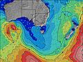 | ||||||||||||||
Onda Altezza (m) Direzione Periodo (s) | SW 16 | SW 16 | SW 15 | SW 15 | SW 14 | SW 14 | SW 14 | SW 13 | SW 13 | SW 13 | WSW 12 | WSW 14 | SW 15 | SW 17 | SW 18 | SW 17 | SW 17 | SSW 17 | SSW 16 | SSW 16 | SW 16 | SW 16 | SW 15 | SW 15 |
Grafico delle onde | ||||||||||||||||||||||||
6651 | 6158 | 5157 | 3797 | 2985 | 2356 | 2191 | 1890 | 1643 | 1452 | 1453 | 1688 | 2065 | 2652 | 3183 | 2893 | 2483 | 2269 | 1809 | 1671 | 1101 | 964 | 743 | 543 | |
Vento (km/h) | ||||||||||||||||||||||||
Stato del vento onshore cross-onshore cross-shore cross-offshore offshore piatto | cross-off | cross-off | cross-off | cross-off | cross-off | cross-off | cross-off | cross | cross-off | cross | cross-on | cross-on | cross-on | on | on | cross-on | cross-on | cross-on | cross-on | cross-on | cross-on | cross | cross-off | cross-off |
Alta Marea | 2:28PM2.26m | 2:09AM1.90m | 3:03PM2.30m | 2:54AM1.93m | 3:36PM2.32m | 3:37AM1.96m | ||||||||||||||||||
Basso Marea | 8:36PM0.88m | 8:24AM0.41m | 9:15PM0.79m | 9:02AM0.44m | 9:51PM0.70m | 9:40AM0.49m | ||||||||||||||||||
— | — | — | — | — | — | 7:37 | — | — | — | — | — | — | — | 7:35 | — | — | — | — | — | — | — | 7:35 | — | |
— | 5:08 | — | — | — | — | — | — | — | 5:08 | — | — | — | — | — | — | — | 5:09 | — | — | — | — | — | 5:09 | |
mm | 1 | 1 | — | — | — | — | — | — | — | 1 | — | — | — | — | — | — | — | — | — | — | — | — | — | — |
Temp. °C | 13 | 12 | 12 | 12 | 12 | 12 | 12 | 12 | 12 | 12 | 11 | 11 | 11 | 11 | 11 | 10 | 11 | 11 | 9 | 8 | 9 | 8 | 9 | 10 |
Gelo °C | 3 | 2 | 2 | 4 | 5 | 5 | 3 | 4 | 5 | 5 | 5 | 4 | 5 | 4 | 4 | 5 | 5 | 5 | 2 | 2 | 4 | 2 | 5 | 7 |
Onda 1 Altezza (m) Direzione Periodo (s) | — | — | — | — | — | — | — | — | — | — | WSW 12 | WSW 14 | SW 15 | SW 17 | SW 18 | SW 17 | SW 17 | SSW 17 | SSW 16 | SSW 16 | SW 16 | SW 16 | SW 15 | SW 15 |
— | — | — | — | — | — | — | — | — | — | 1453 | 1638 | 2065 | 2652 | 3183 | 2893 | 2483 | 2269 | 1809 | 1671 | 1101 | 964 | 743 | 543 | |
Onda 2 Altezza (m) Direzione Periodo (s) | — | — | — | — | — | — | — | — | — | — | SSW 14 | SSW 15 | WSW 17 | SSW 16 | SSW 17 | SSW 16 | SSW 17 | SSW 16 | — | — | — | SE 5 | SE 5 | SE 5 |
— | — | — | — | — | — | — | — | — | — | 378 | 512 | 373 | 1967 | 1799 | 1375 | 627 | 469 | — | — | — | 9 | 7 | 4 | |
Onda 3 Altezza (m) Direzione Periodo (s) | — | — | — | — | — | — | — | — | — | — | — | — | — | — | — | — | — | — | — | — | — | — | — | — |
— | — | — | — | — | — | — | — | — | — | — | — | — | — | — | — | — | — | — | — | — | — | — | — | |
onde vento Altezza (m) Direzione Periodo (s) | SW 16 | SW 16 | SW 15 | SW 15 | SW 14 | SW 14 | SW 14 | SW 13 | SW 13 | SW 13 | SW 13 | SW 14 | SSW 16 | — | — | SSE 5 | — | SE 4 | ESE 4 | NE 3 | ESE 5 | NE 3 | NE 4 | NE 3 |
6651 | 6158 | 5157 | 3797 | 2985 | 2356 | 2191 | 1890 | 1643 | 1452 | 1408 | 1688 | 1991 | — | — | 19 | — | 24 | 44 | 2 | 19 | 2 | 10 | 3 | |
Il più vicino Offshore or Glassy | ||||||||||||||||||||||||
Distanza (km) | 477 | 520 | 84 | 84 | 84 | 84 | 84 | 84 | 95 | 442 | 12 | 116 | 248 | 116 | 101 | 11 | 58 | 58 | 101 | 101 | 58 | 3 | 0 | 0 |
Migliori previsioni per le condizioni d'onda in Phillip Island | ||||||||||||||||||||||||
Migliori previsioni per le condizioni d'onda in Australia | ||||||||||||||||||||||||
Trova Onde Globale | ||||||||||||||||||||||||
- Map Icons:
 Break
Break Live Wave Height (m)
 Live Wind Speed (km/h)
 Surf Rating (10 Max)
 Ocean Swells (m)
- Wind Speed (km/h)
Widget Free Surf-Forecast.com per il tuo sito
La relazione di surf / widget meteo è disponibile qui sotto per incorporare su siti esterni a titolo gratuito e fornisce una sintesi delle nostre Express Point previsione surf. Basta prendere il frammento di codice html da noi fornito e copiarlo nel proprio sito. È possibile scegliere la lingua preferita e unità metriche / imperiali per il feed delle previsioni surf per soddisfare le esigenze degli utenti del vostro sito .... Clicca qui per ottenere il codice.
 Nearest