

Fannie Bay Surf Guide
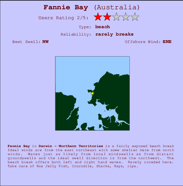
Fannie Bay in Darwin - Northern Territories is a quite exposed beach break Offshore winds blow from the east northeast with some shelter here from north winds. Waves just as likely from local windswells as from distant groundswells and the ideal swell angle is from the northwest. The beach break provides left and right handers. Rarely crowded here. Beware of Box Jelly Fish, Crocodile, Sharks, Rays, rips.
Fannie Bay Spot Info
| Type: | Rating: | Reliability: | Todays Sea Temp*: |
|---|---|---|---|
| rarely breaks | 26.4°C*ocean temperature recorded from satellite |
Surfing Fannie Bay:
The best conditions reported for surf at Fannie Bay occur when a Northwest swell combines with an offshore wind direction from the East-northeast.
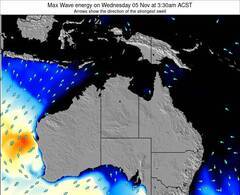
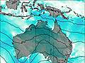
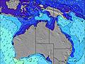
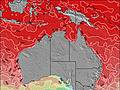
Previsioni Energia d'onda (Potenza): 12hrs
Fannie Bay Surf:
Saturday, 18 July 2026, 19:44 Local time| Dom | ||||
| 6:30PM | 9:30PM | 0:30AM | 3:30AM | |
| Wave (m) | ||||
| Periodo (s) | - | - | - | - |
| Vento (km/h) | ||||
| Stato del vento | cross- off |
cross- on |
cross- off |
cross- off |
- /breaks/Fannie-Bay/forecasts/latest
Fannie Bay Surf Guide
Fannie Bay in Darwin - Northern Territories is a quite exposed beach break Offshore winds blow from the east northeast with some shelter here from north winds. Waves just as likely from local windswells as from distant groundswells and the ideal swell angle is from the northwest. The beach break provides left and right handers. Rarely crowded here. Beware of Box Jelly Fish, Crocodile, Sharks, Rays, rips.
Fannie Bay Spot Info
Type: Rating: Reliability: Todays Sea Temp*:  Beach
Beach 2
2rarely breaks 26.4°C*ocean temperature recorded from satelliteSurfing Fannie Bay:
The best conditions reported for surf at Fannie Bay occur when a Northwest swell combines with an offshore wind direction from the East-northeast.
Previsioni Energia d'onda (Potenza): 12hrs
Utilizzare la scheda di navigazione in alto per visualizzare Fannie Bay temperatura del mare, Fannie Bay fotografie, Fannie Bay dettagliate previsioni onde, il vento e le previsioni meteo, Fannie Bay webcam, vento corrente da NT - Darwin stazioni meteo e Fannie Bay previsioni marea. Il link Australia mappe maree apre l'immagine grande, che mostra Australia e dei mari circostanti. Queste mappe possono essere animate per mostrare le diverse componenti del moto ondoso, energia delle onde, periodo d'onda, altezza delle onde, insieme con le previsioni del vento e meteo, meteo corrente e osservazioni sullo stato del mare dal Australia onda-boe, le navi passanti e stazioni meteo costiere. Ciascuna delle pagine di previsioni per questo surf break rappresenta uno strumento di wavefinder globale e regionale per individuare le migliori condizioni di surf nella zona intorno Fannie Bay.
Fannie Bay Surf:
Saturday, 18 July 2026, 19:44 Local timeDom 6:30PM 9:30PM 0:30AM 3:30AM Wave (m) Periodo (s) - - - - Vento (km/h) Stato del vento cross-
offcross-
oncross-
offcross-
off- /breaks/Fannie-Bay/forecasts/latest
- /breaks/Fannie-Bay/forecasts/latest/six_day
Fannie Bay Surf Guide
Fannie Bay in Darwin - Northern Territories is a quite exposed beach break Offshore winds blow from the east northeast with some shelter here from north winds. Waves just as likely from local windswells as from distant groundswells and the ideal swell angle is from the northwest. The beach break provides left and right handers. Rarely crowded here. Beware of Box Jelly Fish, Crocodile, Sharks, Rays, rips.
Fannie Bay Spot Info
Type: Rating: Reliability: Todays Sea Temp*: Beach2rarely breaks 26.4°C*ocean temperature recorded from satelliteSurfing Fannie Bay:
The best conditions reported for surf at Fannie Bay occur when a Northwest swell combines with an offshore wind direction from the East-northeast.
Previsioni Energia d'onda (Potenza): 12hrs
Utilizzare la scheda di navigazione in alto per visualizzare Fannie Bay temperatura del mare, Fannie Bay fotografie, Fannie Bay dettagliate previsioni onde, il vento e le previsioni meteo, Fannie Bay webcam, vento corrente da NT - Darwin stazioni meteo e Fannie Bay previsioni marea. Il link Australia mappe maree apre l'immagine grande, che mostra Australia e dei mari circostanti. Queste mappe possono essere animate per mostrare le diverse componenti del moto ondoso, energia delle onde, periodo d'onda, altezza delle onde, insieme con le previsioni del vento e meteo, meteo corrente e osservazioni sullo stato del mare dal Australia onda-boe, le navi passanti e stazioni meteo costiere. Ciascuna delle pagine di previsioni per questo surf break rappresenta uno strumento di wavefinder globale e regionale per individuare le migliori condizioni di surf nella zona intorno Fannie Bay.
Fannie Bay Surf:
Saturday, 18 July 2026, 19:44 Local timeDom 6:30PM 9:30PM 0:30AM 3:30AM Wave (m) Periodo (s) - - - - Vento (km/h) Stato del vento cross-
offcross-
oncross-
offcross-
off- /breaks/Fannie-Bay/forecasts/latest
Fannie Bay Surf Guide
Fannie Bay in Darwin - Northern Territories is a quite exposed beach break Offshore winds blow from the east northeast with some shelter here from north winds. Waves just as likely from local windswells as from distant groundswells and the ideal swell angle is from the northwest. The beach break provides left and right handers. Rarely crowded here. Beware of Box Jelly Fish, Crocodile, Sharks, Rays, rips.
Fannie Bay Spot Info
Type: Rating: Reliability: Todays Sea Temp*: Beach2rarely breaks 26.4°C*ocean temperature recorded from satelliteSurfing Fannie Bay:
The best conditions reported for surf at Fannie Bay occur when a Northwest swell combines with an offshore wind direction from the East-northeast.
Previsioni Energia d'onda (Potenza): 12hrs
Utilizzare la scheda di navigazione in alto per visualizzare Fannie Bay temperatura del mare, Fannie Bay fotografie, Fannie Bay dettagliate previsioni onde, il vento e le previsioni meteo, Fannie Bay webcam, vento corrente da NT - Darwin stazioni meteo e Fannie Bay previsioni marea. Il link Australia mappe maree apre l'immagine grande, che mostra Australia e dei mari circostanti. Queste mappe possono essere animate per mostrare le diverse componenti del moto ondoso, energia delle onde, periodo d'onda, altezza delle onde, insieme con le previsioni del vento e meteo, meteo corrente e osservazioni sullo stato del mare dal Australia onda-boe, le navi passanti e stazioni meteo costiere. Ciascuna delle pagine di previsioni per questo surf break rappresenta uno strumento di wavefinder globale e regionale per individuare le migliori condizioni di surf nella zona intorno Fannie Bay.
Fannie Bay Surf:
Saturday, 18 July 2026, 19:44 Local timeDom 6:30PM 9:30PM 0:30AM 3:30AM Wave (m) Periodo (s) - - - - Vento (km/h) Stato del vento cross-
offcross-
oncross-
offcross-
offTide Times:
Per Night Cliff, Australia, %{dist} %{km} da %{location}.
PROSSIMA È ALLE (ora locale) rimanente alta marea bassa marea Fannie Bay Tide Times and Tide Chart
Live Weather:
At Darwin Ntc Aws, 6 km from Fannie Bay.
-
no reportAir temperature
-°COverall Fannie Bay Surf Consistency and Wind Distribution in Luglio
foto dall' album
Contorni: Strade e fiumi: seleziona un surf break dal menu 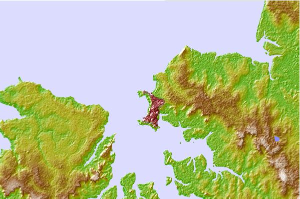
Utilizzare questa mappa sollievo per navigare NT - Darwin surf breaks e stazioni di marea che si trovano nella zona diFannie Bay
Altri surf breaks più vicini al Fannie Bay:
(clicca sul nome del luogo per maggiori informazioni)- Closest località surf4 mi
- Second closest località surf4 mi
- Third closest località surf4 mi
- Fourth closest località surf11 mi
- Fifth closest località surf433 mi
Onda boe più vicina a Fannie Bay:
- Closest Onda boa732 mi
- Second closest Onda boa1039 mi
- Third closest Onda boa1175 mi
- Fourth closest Onda boa1255 mi
- Fifth closest Onda boa1357 mi
Stazioni di marea più vicina alla Fannie Bay:
- Closest marea stazioneNight Cliff2 mi
- Second closest marea stazioneDarwin3 mi
- Third closest marea stazioneTapa Bay16 mi
- Fourth closest marea stazioneBurge Point21 mi
- Fifth closest marea stazioneCape Hotham40 mi
Airports
- The nearest passenger airport to Fannie Bay is Kununurra Airport (KNX) in Australia, which is 438 km (272 miles) away (directly).
- The second closest airport to Fannie Bay is El Tari (Kupang) Airport (KOE) in Indonesia, 820 km (509 miles) away.
- /breaks/Fannie-Bay/forecasts/latest


 Nearest