
Previsioni:

Previsione a breve termineper lo più asciutto. Very mild (Max 19°C giovedì pomeriggio, Min 12°C giovedì mattina). Principalmente venti freschi. | |||||||||||||||||||||
Mar 21 | Mercoledì 22 | Giovedì 23 | |||||||||||||||||||
11 AM | 2 PM | 5 PM | 8 PM | 11 PM | 2 AM | 5 AM | 8 AM | 11 AM | 2 PM | 5 PM | 8 PM | 11 PM | 2 AM | 5 AM | 8 AM | 11 AM | 2 PM | 5 PM | 8 PM | 11 PM | |
Mappa dell'altezza del moto ondoso |  |  | 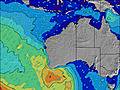 |  |  |  |  |  | |||||||||||||
Onda Altezza (m) Direzione Periodo (s) | SW 14 | SW 14 | SW 14 | SW 14 | SW 14 | SW 13 | SW 13 | SW 13 | SW 13 | SW 13 | SW 13 | SW 16 | SW 16 | SSW 16 | SSW 15 | SW 14 | SW 14 | SSW 14 | SW 14 | SSW 14 | SW 14 |
Grafico delle onde | |||||||||||||||||||||
648 | 630 | 721 | 890 | 865 | 780 | 757 | 816 | 734 | 841 | 732 | 1737 | 1715 | 1997 | 1821 | 1220 | 1220 | 1142 | 1031 | 947 | 731 | |
Vento (km/h) | |||||||||||||||||||||
Stato del vento onshore cross-onshore cross-shore cross-offshore offshore piatto | cross-off | cross | cross-on | cross | cross-off | cross-off | cross-off | cross-off | cross-off | cross-off | cross | cross | cross-off | cross-off | cross-off | cross-off | cross-off | cross-off | cross-off | cross-off | cross-off |
Alta Marea | 3:40AM0.59m | 4:21AM0.61m | |||||||||||||||||||
Basso Marea | 5:51PM0.18m | 5:25PM0.16m | 4:44PM0.14m | ||||||||||||||||||
— | — | — | — | — | — | 7:09 | — | — | — | — | — | — | — | 7:09 | — | — | — | — | — | — | |
— | — | 5:43 | — | — | — | — | — | — | — | 5:44 | — | — | — | — | — | — | — | 5:44 | — | — | |
mm | — | — | — | — | — | — | — | — | — | — | — | — | — | — | — | — | — | — | — | — | — |
Temp. °C | 16 | 17 | 18 | 17 | 16 | 15 | 14 | 13 | 15 | 17 | 17 | 16 | 14 | 13 | 13 | 12 | 15 | 18 | 19 | 18 | 17 |
Gelo °C | 12 | 12 | 14 | 14 | 12 | 11 | 9 | 8 | 10 | 12 | 12 | 10 | 8 | 6 | 6 | 5 | 8 | 12 | 14 | 12 | 11 |
Onda 1 Altezza (m) Direzione Periodo (s) | SW 14 | SW 14 | SW 14 | SW 14 | SW 14 | SW 13 | SW 13 | SW 13 | SW 13 | SW 13 | SW 13 | SW 16 | SW 16 | SSW 16 | SSW 15 | SW 14 | SW 14 | SSW 14 | SW 14 | SSW 14 | SW 14 |
648 | 630 | 721 | 890 | 865 | 780 | 757 | 816 | 734 | 841 | 732 | 1737 | 1715 | 1997 | 1821 | 1220 | 1220 | 1142 | 1031 | 947 | 731 | |
Onda 2 Altezza (m) Direzione Periodo (s) | — | — | — | — | — | SW 18 | SW 18 | — | — | SW 16 | SW 16 | — | — | — | — | S 5 | — | — | — | — | — |
— | — | — | — | — | 12 | 12 | — | — | 421 | 395 | — | — | — | — | 9 | — | — | — | — | — | |
Onda 3 Altezza (m) Direzione Periodo (s) | — | — | — | — | — | — | — | — | — | — | — | — | — | — | — | — | — | — | — | — | — |
— | — | — | — | — | — | — | — | — | — | — | — | — | — | — | — | — | — | — | — | — | |
onde vento Altezza (m) Direzione Periodo (s) | — | — | — | — | — | — | — | ESE 3 | ESE 3 | SE 3 | — | SE 3 | SSE 5 | ESE 4 | E 4 | E 4 | E 4 | E 4 | — | E 3 | ESE 3 |
— | — | — | — | — | — | — | 3 | 2 | 2 | — | 2 | 24 | 14 | 17 | 13 | 13 | 7 | — | 5 | 3 | |
Il più vicino Offshore or Glassy | |||||||||||||||||||||
Distanza (km) | 16 | 27 | 27 | 27 | 0 | 16 | 16 | 16 | 16 | 16 | 16 | 30 | 30 | 30 | 221 | 275 | 275 | 6 | 16 | 16 | 16 |
Migliori previsioni per le condizioni d'onda in North West WA | |||||||||||||||||||||
Migliori previsioni per le condizioni d'onda in Australia | |||||||||||||||||||||
Trova Onde Globale | |||||||||||||||||||||
- Map Icons:
 Break
Break Live Wave Height (m)
 Live Wind Speed (km/h)
 Surf Rating (10 Max)
 Ocean Swells (m)
- Wind Speed (km/h)
Widget Free Surf-Forecast.com per il tuo sito
La relazione di surf / widget meteo è disponibile qui sotto per incorporare su siti esterni a titolo gratuito e fornisce una sintesi delle nostre Greenough previsione surf. Basta prendere il frammento di codice html da noi fornito e copiarlo nel proprio sito. È possibile scegliere la lingua preferita e unità metriche / imperiali per il feed delle previsioni surf per soddisfare le esigenze degli utenti del vostro sito .... Clicca qui per ottenere il codice.
 Nearest