
Previsioni:

Previsione a breve terminepioggia leggera (Totale 4mm), per lo più che cade Domenica mattina. Warm (Max 26°C Domenica mattina, Min 25°C Sabato notte). Principalmente venti freschi. | ||||||||||||||||||
25 | Domenica 26 | Lunedì 27 | ||||||||||||||||
7 PM | 10 PM | 1 AM | 4 AM | 7 AM | 10 AM | 1 PM | 4 PM | 7 PM | 10 PM | 1 AM | 4 AM | 7 AM | 10 AM | 1 PM | 4 PM | 7 PM | 10 PM | |
Mappa dell'altezza del moto ondoso | 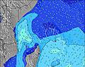 | 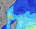 | 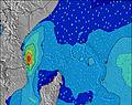 | 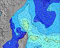 | 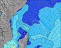 | 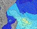 | 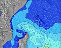 | |||||||||||
Onda Altezza (m) Direzione Periodo (s) | SSE 8 | SSW 8 | SSW 8 | SSW 8 | SSW 8 | SSW 8 | SSW 8 | SSW 7 | SSW 16 | SSW 16 | S 7 | SE 8 | SE 7 | SE 7 | SE 7 | SE 6 | SE 7 | SE 7 |
Grafico delle onde | ||||||||||||||||||
390 | 125 | 140 | 144 | 137 | 107 | 102 | 91 | 89 | 86 | 94 | 204 | 231 | 219 | 255 | 209 | 244 | 244 | |
Vento (km/h) | ||||||||||||||||||
Stato del vento onshore cross-onshore cross-shore cross-offshore offshore piatto | cross-on | cross-on | cross-on | cross-on | cross-on | cross-on | cross-on | cross-on | cross-on | cross | cross | cross-on | cross-on | cross | cross | cross | cross | cross |
Alta Marea | 3:04AM0.63m | 3:02PM1.20m | 3:51AM0.69m | 3:44PM1.27m | ||||||||||||||
Basso Marea | 9:38PM0.34m | 7:54AM0.41m | 10:15PM0.26m | 8:53AM0.36m | ||||||||||||||
— | — | — | 6:26 | — | — | — | — | — | — | — | 6:26 | — | — | — | — | — | — | |
— | — | — | — | — | — | — | 6:21 | — | — | — | — | — | — | — | 6:21 | — | — | |
mm | — | — | — | — | — | — | — | 1 | — | 1 | — | — | — | — | 1 | — | — | — |
Temp. °C | 25 | 25 | 25 | 25 | 25 | 26 | 26 | 26 | 26 | 25 | 26 | 26 | 26 | 26 | 26 | 26 | 26 | 26 |
Gelo °C | 23 | 24 | 25 | 24 | 25 | 26 | 26 | 27 | 26 | 25 | 26 | 25 | 25 | 26 | 25 | 25 | 25 | 25 |
Onda 1 Altezza (m) Direzione Periodo (s) | S 12 | ESE 8 | ESE 8 | ESE 8 | ESE 8 | ESE 8 | SE 8 | ESE 8 | ESE 8 | ESE 8 | ESE 8 | S 10 | S 10 | S 10 | S 10 | S 10 | S 10 | S 10 |
141 | 230 | 179 | 179 | 179 | 140 | 154 | 140 | 140 | 128 | 143 | 78 | 71 | 68 | 68 | 90 | 68 | 70 | |
Onda 2 Altezza (m) Direzione Periodo (s) | S 16 | SSW 8 | SSW 8 | S 12 | SSW 8 | S 11 | S 11 | S 11 | S 11 | S 11 | S 11 | SSW 16 | SSW 15 | SE 11 | SE 11 | SE 9 | SE 9 | SE 9 |
21 | 125 | 140 | 67 | 137 | 59 | 57 | 57 | 37 | 61 | 56 | 82 | 74 | 55 | 40 | 42 | 42 | 41 | |
Onda 3 Altezza (m) Direzione Periodo (s) | SE 12 | S 12 | S 12 | SSW 15 | S 11 | S 17 | SSW 15 | SSW 17 | SSW 16 | SSW 16 | SSW 16 | SSE 11 | SE 11 | SSW 15 | SSW 15 | SSW 14 | SSW 14 | SSW 13 |
6 | 100 | 98 | 22 | 64 | 24 | 21 | 57 | 87 | 86 | 84 | 45 | 41 | 72 | 71 | 69 | 37 | 35 | |
onde vento Altezza (m) Direzione Periodo (s) | SSE 8 | — | — | SSW 8 | — | SSW 8 | SSW 8 | SSW 7 | SSW 7 | S 7 | S 7 | SE 8 | SE 7 | SE 7 | SE 7 | SE 6 | SE 7 | SE 7 |
390 | — | — | 144 | — | 107 | 102 | 91 | 89 | 81 | 94 | 204 | 231 | 219 | 255 | 209 | 244 | 244 | |
Il più vicino Offshore or Glassy | ||||||||||||||||||
Distanza (km) | 1716 | 6 | 6 | 6 | 6 | 6 | 6 | 6 | 6 | 6 | 1705 | 1705 | 1705 | 1705 | 1720 | 1716 | 1705 | 1705 |
Migliori previsioni per le condizioni d'onda in Mahe | ||||||||||||||||||
Migliori previsioni per le condizioni d'onda in Seychelles | ||||||||||||||||||
Trova Onde Globale | ||||||||||||||||||
- Map Icons:
 Break
Break Live Wave Height (m)
 Live Wind Speed (km/h)
 Surf Rating (10 Max)
 Ocean Swells (m)
- Wind Speed (km/h)
Widget Free Surf-Forecast.com per il tuo sito
La relazione di surf / widget meteo è disponibile qui sotto per incorporare su siti esterni a titolo gratuito e fornisce una sintesi delle nostre Anse Intendance previsione surf. Basta prendere il frammento di codice html da noi fornito e copiarlo nel proprio sito. È possibile scegliere la lingua preferita e unità metriche / imperiali per il feed delle previsioni surf per soddisfare le esigenze degli utenti del vostro sito .... Clicca qui per ottenere il codice.
 Nearest