
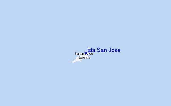
Isla San Jose Surf Guide
Isla San Jose in Fernando do Noronha is an exposed beach and reef break that usually has waves. Summer offers the best conditions for surfing. The best wind direction is from the south. Groundswells are more common than windswells and the best swell direction is from the north northwest. The beach break provides left and right handers and in addition, both left and right reef breaks add variety.. Best around mid tide. It very rarely gets crowded here. Take care of urchins, rocks and sharks.
Isla San Jose Spot Info
| Type: | Rating: | Reliability: | Todays Sea Temp*: |
|---|---|---|---|
| consistent | 27.1°C*ocean temperature recorded from satellite |
Surfing Isla San Jose:
The best conditions reported for surf at Isla San Jose occur when a North-northwest swell combines with an offshore wind direction from the South.
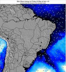
Previsioni Energia d'onda (Potenza): 12hrs


Isla San Jose Surf:
Tuesday, 21 July 2026, 09:24 Local time| Martedì 21 | ||||
| 7AM | 10AM | 1PM | 4PM | |
| Wave (m) | ||||
| Periodo (s) | 9 | 9 | 8 | 8 |
| Vento (km/h) | ||||
| Stato del vento | cross | cross | cross- off |
cross- off |
- /breaks/Isla-San-Jose/forecasts/latest
Isla San Jose Surf Guide
Isla San Jose in Fernando do Noronha is an exposed beach and reef break that usually has waves. Summer offers the best conditions for surfing. The best wind direction is from the south. Groundswells are more common than windswells and the best swell direction is from the north northwest. The beach break provides left and right handers and in addition, both left and right reef breaks add variety.. Best around mid tide. It very rarely gets crowded here. Take care of urchins, rocks and sharks.
Isla San Jose Spot Info
Type: Rating: Reliability: Todays Sea Temp*:  Beach and reef
 2
2consistent 27.1°C*ocean temperature recorded from satelliteSurfing Isla San Jose:
The best conditions reported for surf at Isla San Jose occur when a North-northwest swell combines with an offshore wind direction from the South.
Previsioni Energia d'onda (Potenza): 12hrs
Utilizzare la scheda di navigazione in alto per visualizzare Isla San Jose temperatura del mare, Isla San Jose fotografie, Isla San Jose dettagliate previsioni onde, il vento e le previsioni meteo, Isla San Jose webcam, vento corrente da Fernando De Noronha stazioni meteo e Isla San Jose previsioni marea. Il link Brazil mappe maree apre l'immagine grande, che mostra Brazil e dei mari circostanti. Queste mappe possono essere animate per mostrare le diverse componenti del moto ondoso, energia delle onde, periodo d'onda, altezza delle onde, insieme con le previsioni del vento e meteo, meteo corrente e osservazioni sullo stato del mare dal Brazil onda-boe, le navi passanti e stazioni meteo costiere. Ciascuna delle pagine di previsioni per questo surf break rappresenta uno strumento di wavefinder globale e regionale per individuare le migliori condizioni di surf nella zona intorno Isla San Jose.
Isla San Jose Surf:
Tuesday, 21 July 2026, 09:24 Local timeMartedì 21 7AM 10AM 1PM 4PM Wave (m) Periodo (s) 9 9 8 8 Vento (km/h) Stato del vento cross cross cross-
offcross-
off- /breaks/Isla-San-Jose/forecasts/latest
- /breaks/Isla-San-Jose/forecasts/latest/six_day
Isla San Jose Surf Guide
Isla San Jose in Fernando do Noronha is an exposed beach and reef break that usually has waves. Summer offers the best conditions for surfing. The best wind direction is from the south. Groundswells are more common than windswells and the best swell direction is from the north northwest. The beach break provides left and right handers and in addition, both left and right reef breaks add variety.. Best around mid tide. It very rarely gets crowded here. Take care of urchins, rocks and sharks.
Isla San Jose Spot Info
Type: Rating: Reliability: Todays Sea Temp*: Beach and reef2consistent 27.1°C*ocean temperature recorded from satelliteSurfing Isla San Jose:
The best conditions reported for surf at Isla San Jose occur when a North-northwest swell combines with an offshore wind direction from the South.
Previsioni Energia d'onda (Potenza): 12hrs
Utilizzare la scheda di navigazione in alto per visualizzare Isla San Jose temperatura del mare, Isla San Jose fotografie, Isla San Jose dettagliate previsioni onde, il vento e le previsioni meteo, Isla San Jose webcam, vento corrente da Fernando De Noronha stazioni meteo e Isla San Jose previsioni marea. Il link Brazil mappe maree apre l'immagine grande, che mostra Brazil e dei mari circostanti. Queste mappe possono essere animate per mostrare le diverse componenti del moto ondoso, energia delle onde, periodo d'onda, altezza delle onde, insieme con le previsioni del vento e meteo, meteo corrente e osservazioni sullo stato del mare dal Brazil onda-boe, le navi passanti e stazioni meteo costiere. Ciascuna delle pagine di previsioni per questo surf break rappresenta uno strumento di wavefinder globale e regionale per individuare le migliori condizioni di surf nella zona intorno Isla San Jose.
Isla San Jose Surf:
Tuesday, 21 July 2026, 09:24 Local timeMartedì 21 7AM 10AM 1PM 4PM Wave (m) Periodo (s) 9 9 8 8 Vento (km/h) Stato del vento cross cross cross-
offcross-
off- /breaks/Isla-San-Jose/forecasts/latest
Isla San Jose Surf Guide
Isla San Jose in Fernando do Noronha is an exposed beach and reef break that usually has waves. Summer offers the best conditions for surfing. The best wind direction is from the south. Groundswells are more common than windswells and the best swell direction is from the north northwest. The beach break provides left and right handers and in addition, both left and right reef breaks add variety.. Best around mid tide. It very rarely gets crowded here. Take care of urchins, rocks and sharks.
Isla San Jose Spot Info
Type: Rating: Reliability: Todays Sea Temp*: Beach and reef2consistent 27.1°C*ocean temperature recorded from satelliteSurfing Isla San Jose:
The best conditions reported for surf at Isla San Jose occur when a North-northwest swell combines with an offshore wind direction from the South.
Previsioni Energia d'onda (Potenza): 12hrs
Utilizzare la scheda di navigazione in alto per visualizzare Isla San Jose temperatura del mare, Isla San Jose fotografie, Isla San Jose dettagliate previsioni onde, il vento e le previsioni meteo, Isla San Jose webcam, vento corrente da Fernando De Noronha stazioni meteo e Isla San Jose previsioni marea. Il link Brazil mappe maree apre l'immagine grande, che mostra Brazil e dei mari circostanti. Queste mappe possono essere animate per mostrare le diverse componenti del moto ondoso, energia delle onde, periodo d'onda, altezza delle onde, insieme con le previsioni del vento e meteo, meteo corrente e osservazioni sullo stato del mare dal Brazil onda-boe, le navi passanti e stazioni meteo costiere. Ciascuna delle pagine di previsioni per questo surf break rappresenta uno strumento di wavefinder globale e regionale per individuare le migliori condizioni di surf nella zona intorno Isla San Jose.
Isla San Jose Surf:
Tuesday, 21 July 2026, 09:24 Local timeMartedì 21 7AM 10AM 1PM 4PM Wave (m) Periodo (s) 9 9 8 8 Vento (km/h) Stato del vento cross cross cross-
offcross-
offTide Times:
Per Fernando de Noronha, Brazil, %{dist} %{km} da %{location}.
PROSSIMA È ALLE (ora locale) rimanente alta marea bassa marea Isla San Jose Tide Times and Tide Chart
Live Weather:
At Fernando De Noro Airport, 2 km from Isla San Jose.
light winds from the E.(Wind varies from 050 to 130 degs)
(km/h)
Dry and partly cloudyAir temperature
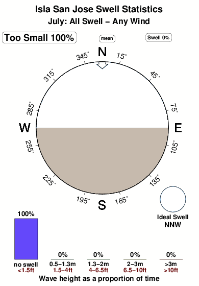
25°COverall Isla San Jose Surf Consistency and Wind Distribution in Luglio
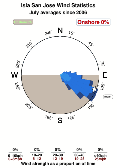


Wind stats for Isla San Jose: see the variation in direction and stength by month.
foto dall' album
Contorni: Strade e fiumi: seleziona un surf break dal menu 
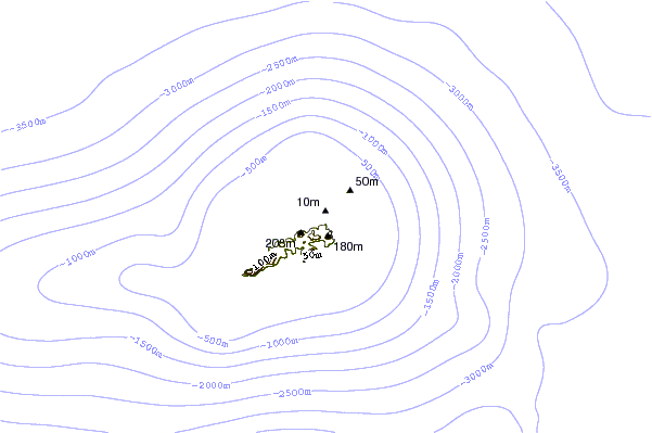
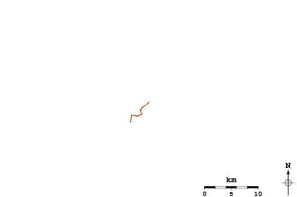
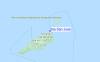
Utilizzare questa mappa sollievo per navigare Fernando De Noronha surf breaks e stazioni di marea che si trovano nella zona diIsla San Jose
Altri surf breaks più vicini al Isla San Jose:
(clicca sul nome del luogo per maggiori informazioni)- Closest località surf0 mi
- Second closest località surf0 mi
- Third closest località surf1 mi
- Fourth closest località surf1 mi
- Fifth closest località surf1 mi
Onda boe più vicina a Isla San Jose:
- Closest Onda boa1566 mi
- Second closest Onda boa1897 mi
- Third closest Onda boa2070 mi
- Fourth closest Onda boa2226 mi
- Fifth closest Onda boa2254 mi
Stazioni di marea più vicina alla Isla San Jose:
- Closest marea stazioneFernando de Noronha1 mi
- Second closest marea stazioneRocas, Atol das98 mi
- Third closest marea stazioneTouros231 mi
- Fourth closest marea stazioneNatal235 mi
- Fifth closest marea stazioneAres250 mi
Airports
- The nearest passenger airport to Isla San Jose is Fernando De Noronha Airport (FEN) in Brazil, which is 3 km (2 miles) away (directly).
- The second closest airport to Isla San Jose is Augusto Severo (Natal) Airport (NAT), also in Brazil, 391 km (243 miles) away.

- /breaks/Isla-San-Jose/forecasts/latest

 Nearest