
Previsioni:

Previsione a breve termineper lo più asciutto. Very mild (Max 14°C Domenica mattina, Min 10°C Domenica mattina). Venti in aumento (venti deboli da N Domenica mattina, venti freschi da NNW per martedì notte). | ||||||||||||||||||||||
Domenica 19 | Lunedì 20 | Martedì 21 | ||||||||||||||||||||
7 AM | 10 AM | 1 PM | 4 PM | 7 PM | 10 PM | 1 AM | 4 AM | 7 AM | 10 AM | 1 PM | 4 PM | 7 PM | 10 PM | 1 AM | 4 AM | 7 AM | 10 AM | 1 PM | 4 PM | 7 PM | 10 PM | |
Mappa dell'altezza del moto ondoso |  |  |  | 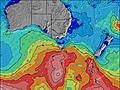 |  |  | 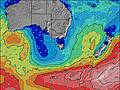 |  | ||||||||||||||
Onda Altezza (m) Direzione Periodo (s) | SW 13 | SW 13 | SW 12 | SW 12 | SW 12 | SW 18 | SW 18 | SW 17 | SW 16 | SW 16 | SW 16 | SW 15 | SW 15 | SW 15 | SW 14 | SW 15 | SW 15 | SW 14 | SW 13 | SW 13 | SW 13 | SW 13 |
Grafico delle onde | ||||||||||||||||||||||
273 | 228 | 214 | 172 | 144 | 116 | 111 | 186 | 163 | 361 | 357 | 331 | 136 | 268 | 251 | 380 | 543 | 639 | 511 | 495 | 437 | 369 | |
Vento (km/h) | ||||||||||||||||||||||
Stato del vento onshore cross-onshore cross-shore cross-offshore offshore piatto | off | off | cross-off | cross-off | off | off | cross-off | cross-off | cross-off | cross-off | cross-off | cross-off | cross-off | cross-off | cross-off | cross-off | cross-off | cross-off | cross-off | cross-off | cross-off | cross-off |
Alta Marea | 3:25PM2.44m | 3:47AM2.21m | 4:05PM2.41m | 4:38AM2.18m | 4:43PM2.34m | |||||||||||||||||
Basso Marea | 9:02AM0.23m | 9:42PM0.33m | 9:50AM0.37m | 10:27PM0.26m | 10:34AM0.51m | |||||||||||||||||
7:30 | — | — | — | — | — | — | — | 7:30 | — | — | — | — | — | — | — | 7:28 | — | — | — | — | — | |
— | — | — | 5:17 | — | — | — | — | — | — | — | 5:19 | — | — | — | — | — | — | — | 5:19 | — | — | |
mm | — | — | — | — | — | — | — | — | — | — | — | — | — | — | — | — | — | — | — | — | — | — |
Temp. °C | 11 | 11 | 12 | 13 | 14 | 14 | 12 | 11 | 10 | 11 | 13 | 14 | 14 | 13 | 12 | 11 | 11 | 10 | 12 | 14 | 13 | 12 |
Gelo °C | 8 | 7 | 9 | 11 | 11 | 11 | 8 | 7 | 5 | 6 | 8 | 10 | 10 | 9 | 8 | 7 | 7 | 6 | 8 | 10 | 8 | 7 |
Onda 1 Altezza (m) Direzione Periodo (s) | SW 13 | SW 13 | SW 12 | SW 12 | SW 12 | SW 12 | SW 12 | SW 12 | SW 16 | SW 16 | SW 16 | SW 15 | WSW 12 | SW 15 | SW 14 | SW 15 | SW 15 | SW 14 | SW 13 | SW 13 | SW 13 | SW 13 |
273 | 228 | 214 | 172 | 144 | 116 | 87 | 71 | 163 | 361 | 357 | 331 | 94 | 255 | 251 | 380 | 543 | 639 | 511 | 495 | 437 | 369 | |
Onda 2 Altezza (m) Direzione Periodo (s) | SW 21 | SW 21 | SW 20 | SW 20 | SW 19 | SW 18 | SW 18 | SW 17 | SW 12 | S 10 | SSW 10 | — | SW 15 | WSW 14 | SW 18 | WSW 9 | S 10 | — | — | — | — | — |
18 | 17 | 60 | 60 | 55 | 112 | 111 | 186 | 67 | 2 | 9 | — | 136 | 268 | 13 | 80 | 2 | — | — | — | — | — | |
Onda 3 Altezza (m) Direzione Periodo (s) | SW 21 | WSW 20 | WSW 20 | WSW 20 | SW 11 | SSW 11 | SW 11 | SSW 11 | SSW 10 | — | SE 11 | WSW 12 | WSW 12 | S 11 | WSW 18 | SE 11 | — | — | — | — | — | — |
18 | 40 | 38 | 37 | 5 | 13 | 29 | 11 | 9 | — | 5 | 14 | 14 | 2 | 32 | 5 | — | — | — | — | — | — | |
onde vento Altezza (m) Direzione Periodo (s) | — | — | — | — | — | — | — | NW 2 | NW 3 | NW 3 | NW 3 | NNW 4 | NNW 2 | NW 3 | NW 3 | NW 3 | NW 3 | NNW 3 | NNW 3 | NW 3 | NNW 3 | NNW 3 |
— | — | — | — | — | — | — | 1 | 2 | 4 | 4 | 9 | 1 | 2 | 2 | 2 | 5 | 6 | 2 | 5 | 4 | 3 | |
Il più vicino Offshore or Glassy | ||||||||||||||||||||||
Distanza (km) | 0 | 0 | 0 | 0 | 0 | 0 | 0 | 5 | 5 | 5 | 5 | 5 | 5 | 5 | 5 | 0 | 5 | 0 | 0 | 0 | 5 | 5 |
Migliori previsioni per le condizioni d'onda in East Coast of Victoria | ||||||||||||||||||||||
Migliori previsioni per le condizioni d'onda in Australia | ||||||||||||||||||||||
Trova Onde Globale | ||||||||||||||||||||||
- Map Icons:
 Break
Break Live Wave Height (m)
 Live Wind Speed (km/h)
 Surf Rating (10 Max)
 Ocean Swells (m)
- Wind Speed (km/h)
Widget Free Surf-Forecast.com per il tuo sito
La relazione di surf / widget meteo è disponibile qui sotto per incorporare su siti esterni a titolo gratuito e fornisce una sintesi delle nostre Kilcunda previsione surf. Basta prendere il frammento di codice html da noi fornito e copiarlo nel proprio sito. È possibile scegliere la lingua preferita e unità metriche / imperiali per il feed delle previsioni surf per soddisfare le esigenze degli utenti del vostro sito .... Clicca qui per ottenere il codice.
 Nearest