
Previsioni:

Previsione a breve termineper lo più asciutto. Very mild (Max 19°C giovedì mattina, Min 17°C giovedì notte). Vento sarà generalmente leggero. | |||||||||||||||||||||||
Giovedì 16 | Venerdì 17 | Sabato 18 | |||||||||||||||||||||
4 AM | 7 AM | 10 AM | 1 PM | 4 PM | 7 PM | 10 PM | 1 AM | 4 AM | 7 AM | 10 AM | 1 PM | 4 PM | 7 PM | 10 PM | 1 AM | 4 AM | 7 AM | 10 AM | 1 PM | 4 PM | 7 PM | 10 PM | |
Mappa dell'altezza del moto ondoso | 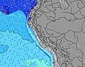 |  | 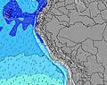 | 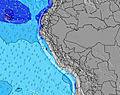 | 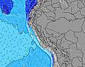 | 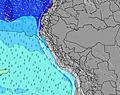 | 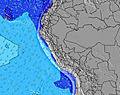 | 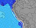 | 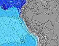 | ||||||||||||||
Onda Altezza (m) Direzione Periodo (s) | SW 13 | SW 13 | SW 13 | SW 13 | SW 13 | SW 13 | SW 12 | SW 12 | SW 12 | SW 12 | SW 12 | SSW 12 | SW 12 | SW 12 | SW 12 | SW 12 | SW 12 | SW 11 | SW 11 | SW 11 | SW 11 | SW 11 | SW 11 |
Grafico delle onde | |||||||||||||||||||||||
480 | 480 | 437 | 431 | 486 | 418 | 398 | 386 | 292 | 297 | 292 | 255 | 209 | 209 | 216 | 216 | 209 | 217 | 246 | 205 | 242 | 246 | 205 | |
Vento (km/h) | |||||||||||||||||||||||
Stato del vento onshore cross-onshore cross-shore cross-offshore offshore piatto | cross-on | cross-on | cross-on | cross-on | cross-on | cross-on | cross-on | cross-on | cross-on | glassy | cross-on | on | cross-on | cross-on | cross-on | on | glassy | glassy | cross-on | on | cross-on | cross-on | glassy |
Alta Marea | 7:47AM1.07m | 7:44PM0.55m | 8:32AM1.02m | 8:46PM0.57m | 9:15AM0.95m | 9:50PM0.59m | |||||||||||||||||
Basso Marea | 2:32PM0.18m | 1:27AM0.05m | 3:19PM0.17m | 2:20AM0.13m | 4:04PM0.17m | ||||||||||||||||||
6:28 | — | — | — | — | — | — | — | 6:28 | — | — | — | — | — | — | — | 6:28 | — | — | — | — | — | — | |
— | — | — | — | 5:54 | — | — | — | — | — | — | — | 5:54 | — | — | — | — | — | — | — | 5:54 | — | — | |
mm | — | — | — | — | — | — | — | — | — | — | — | — | — | — | — | — | — | — | — | — | — | — | — |
Temp. °C | 17 | 17 | 18 | 19 | 18 | 18 | 17 | 17 | 17 | 17 | 18 | 19 | 19 | 17 | 17 | 17 | 17 | 17 | 18 | 19 | 19 | 17 | 17 |
Gelo °C | 17 | 17 | 17 | 18 | 17 | 18 | 17 | 16 | 18 | 18 | 18 | 19 | 19 | 17 | 17 | 17 | 18 | 18 | 18 | 19 | 20 | 17 | 18 |
Onda 1 Altezza (m) Direzione Periodo (s) | SW 13 | SW 13 | SW 13 | SW 13 | SW 13 | SW 13 | SW 12 | SW 12 | SW 12 | SW 12 | SW 12 | SSW 12 | SW 12 | SW 12 | SW 12 | SW 12 | SW 12 | SW 11 | SW 11 | SW 11 | SW 11 | SW 11 | SW 11 |
480 | 480 | 437 | 431 | 486 | 418 | 398 | 386 | 292 | 297 | 292 | 255 | 209 | 209 | 216 | 216 | 209 | 217 | 246 | 205 | 242 | 246 | 205 | |
Onda 2 Altezza (m) Direzione Periodo (s) | NW 12 | NW 12 | W 12 | W 12 | W 12 | W 12 | W 11 | SW 20 | SW 20 | SW 20 | SSW 4 | WSW 18 | SW 18 | WSW 18 | SSW 4 | SSW 5 | SSW 5 | SSW 5 | SSW 5 | SSW 5 | SW 15 | SW 14 | SW 14 |
6 | 6 | 3 | 3 | 3 | 3 | 2 | 16 | 15 | 16 | 3 | 32 | 13 | 31 | 6 | 7 | 8 | 9 | 9 | 9 | 77 | 74 | 73 | |
Onda 3 Altezza (m) Direzione Periodo (s) | — | — | — | — | SW 21 | NW 12 | S 6 | W 11 | W 11 | W 11 | SW 20 | W 11 | W 11 | W 11 | SW 18 | SW 17 | SW 16 | SW 16 | SW 16 | SW 15 | SSW 5 | SSW 5 | SSW 5 |
— | — | — | — | 18 | 5 | 1 | 2 | 2 | 2 | 15 | 2 | 2 | 2 | 13 | 44 | 68 | 42 | 41 | 60 | 9 | 5 | 5 | |
onde vento Altezza (m) Direzione Periodo (s) | — | — | — | S 3 | SSW 3 | S 3 | SSW 4 | SSW 4 | SSW 4 | SSW 4 | — | SSW 4 | SSW 4 | SSW 4 | — | — | — | — | — | — | — | — | — |
— | — | — | 3 | 4 | 2 | 2 | 3 | 3 | 3 | — | 4 | 6 | 6 | — | — | — | — | — | — | — | — | — | |
Il più vicino Offshore or Glassy | |||||||||||||||||||||||
Distanza (km) | 45 | 45 | 45 | 45 | 45 | 45 | 45 | 45 | 7 | 0 | 45 | 45 | 45 | 45 | 45 | 45 | 0 | 0 | 45 | 45 | 45 | 45 | 0 |
Migliori previsioni per le condizioni d'onda in Lima | |||||||||||||||||||||||
Migliori previsioni per le condizioni d'onda in Peru | |||||||||||||||||||||||
Trova Onde Globale | |||||||||||||||||||||||
- Map Icons:
 Break
Break Live Wave Height (m)
 Live Wind Speed (km/h)
 Surf Rating (10 Max)
 Ocean Swells (m)
- Wind Speed (km/h)
Widget Free Surf-Forecast.com per il tuo sito
La relazione di surf / widget meteo è disponibile qui sotto per incorporare su siti esterni a titolo gratuito e fornisce una sintesi delle nostre La Playita previsione surf. Basta prendere il frammento di codice html da noi fornito e copiarlo nel proprio sito. È possibile scegliere la lingua preferita e unità metriche / imperiali per il feed delle previsioni surf per soddisfare le esigenze degli utenti del vostro sito .... Clicca qui per ottenere il codice.
 Nearest