
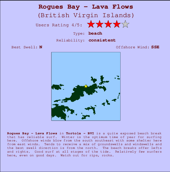
Rogues Bay - Lava Flows Surf Guide
Rogues Bay - Lava Flows in Tortola - BVI is a reasonably exposed beach break that usually has waves. Winter is the best time of year for surfing here. Ideal winds are from the south southeast with some shelter here from east winds. Windswells and groundswells in equal measure and the ideal swell angle is from the north. The beach breaks offer lefts and rights. The quality of the surf isn't affected by the tide. Even when there are waves, it's not likley to be crowded. Beware of rips, rocks.
Rogues Bay - Lava Flows Spot Info
| Type: | Rating: | Reliability: | Todays Sea Temp*: |
|---|---|---|---|
| consistent | 28.4°C*ocean temperature recorded from satellite |
Surfing Rogues Bay - Lava Flows:
The best conditions reported for surf at Rogues Bay - Lava Flows occur when a North swell combines with an offshore wind direction from the South-southeast.

Previsioni Energia d'onda (Potenza): 12hrs


Rogues Bay - Lava Flows Surf:
Monday, 13 July 2026, 02:24 Local time| Dom | Lunedì 13 | |||
| 11PM | 2AM | 5AM | 8AM | |
| Wave (m) | ||||
| Periodo (s) | 8 | 8 | 8 | 8 |
| Vento (km/h) | ||||
| Stato del vento | cross- off |
cross- off |
cross- off |
cross- off |
- /breaks/Lava-Flows/forecasts/latest
Rogues Bay - Lava Flows Surf Guide
Rogues Bay - Lava Flows in Tortola - BVI is a reasonably exposed beach break that usually has waves. Winter is the best time of year for surfing here. Ideal winds are from the south southeast with some shelter here from east winds. Windswells and groundswells in equal measure and the ideal swell angle is from the north. The beach breaks offer lefts and rights. The quality of the surf isn't affected by the tide. Even when there are waves, it's not likley to be crowded. Beware of rips, rocks.
Rogues Bay - Lava Flows Spot Info
Type: Rating: Reliability: Todays Sea Temp*:  Beach
Beach 4
4consistent 28.4°C*ocean temperature recorded from satelliteSurfing Rogues Bay - Lava Flows:
The best conditions reported for surf at Rogues Bay - Lava Flows occur when a North swell combines with an offshore wind direction from the South-southeast.
Previsioni Energia d'onda (Potenza): 12hrs
Utilizzare la scheda di navigazione in alto per visualizzare Rogues Bay - Lava Flows temperatura del mare, Rogues Bay - Lava Flows fotografie, Rogues Bay - Lava Flows dettagliate previsioni onde, il vento e le previsioni meteo, Rogues Bay - Lava Flows webcam, vento corrente da Tortola stazioni meteo e Rogues Bay - Lava Flows previsioni marea. Il link British Virgin Islands mappe maree apre l'immagine grande, che mostra British Virgin Islands e dei mari circostanti. Queste mappe possono essere animate per mostrare le diverse componenti del moto ondoso, energia delle onde, periodo d'onda, altezza delle onde, insieme con le previsioni del vento e meteo, meteo corrente e osservazioni sullo stato del mare dal British Virgin Islands onda-boe, le navi passanti e stazioni meteo costiere. Ciascuna delle pagine di previsioni per questo surf break rappresenta uno strumento di wavefinder globale e regionale per individuare le migliori condizioni di surf nella zona intorno Rogues Bay - Lava Flows.
Rogues Bay - Lava Flows Surf:
Monday, 13 July 2026, 02:24 Local timeDom Lunedì 13 11PM 2AM 5AM 8AM Wave (m) Periodo (s) 8 8 8 8 Vento (km/h) Stato del vento cross-
offcross-
offcross-
offcross-
off- /breaks/Lava-Flows/forecasts/latest
- /breaks/Lava-Flows/forecasts/latest/six_day
Rogues Bay - Lava Flows Surf Guide
Rogues Bay - Lava Flows in Tortola - BVI is a reasonably exposed beach break that usually has waves. Winter is the best time of year for surfing here. Ideal winds are from the south southeast with some shelter here from east winds. Windswells and groundswells in equal measure and the ideal swell angle is from the north. The beach breaks offer lefts and rights. The quality of the surf isn't affected by the tide. Even when there are waves, it's not likley to be crowded. Beware of rips, rocks.
Rogues Bay - Lava Flows Spot Info
Type: Rating: Reliability: Todays Sea Temp*: Beach4consistent 28.4°C*ocean temperature recorded from satelliteSurfing Rogues Bay - Lava Flows:
The best conditions reported for surf at Rogues Bay - Lava Flows occur when a North swell combines with an offshore wind direction from the South-southeast.
Previsioni Energia d'onda (Potenza): 12hrs
Utilizzare la scheda di navigazione in alto per visualizzare Rogues Bay - Lava Flows temperatura del mare, Rogues Bay - Lava Flows fotografie, Rogues Bay - Lava Flows dettagliate previsioni onde, il vento e le previsioni meteo, Rogues Bay - Lava Flows webcam, vento corrente da Tortola stazioni meteo e Rogues Bay - Lava Flows previsioni marea. Il link British Virgin Islands mappe maree apre l'immagine grande, che mostra British Virgin Islands e dei mari circostanti. Queste mappe possono essere animate per mostrare le diverse componenti del moto ondoso, energia delle onde, periodo d'onda, altezza delle onde, insieme con le previsioni del vento e meteo, meteo corrente e osservazioni sullo stato del mare dal British Virgin Islands onda-boe, le navi passanti e stazioni meteo costiere. Ciascuna delle pagine di previsioni per questo surf break rappresenta uno strumento di wavefinder globale e regionale per individuare le migliori condizioni di surf nella zona intorno Rogues Bay - Lava Flows.
Rogues Bay - Lava Flows Surf:
Monday, 13 July 2026, 02:24 Local timeDom Lunedì 13 11PM 2AM 5AM 8AM Wave (m) Periodo (s) 8 8 8 8 Vento (km/h) Stato del vento cross-
offcross-
offcross-
offcross-
off- /breaks/Lava-Flows/forecasts/latest
Rogues Bay - Lava Flows Surf Guide
Rogues Bay - Lava Flows in Tortola - BVI is a reasonably exposed beach break that usually has waves. Winter is the best time of year for surfing here. Ideal winds are from the south southeast with some shelter here from east winds. Windswells and groundswells in equal measure and the ideal swell angle is from the north. The beach breaks offer lefts and rights. The quality of the surf isn't affected by the tide. Even when there are waves, it's not likley to be crowded. Beware of rips, rocks.
Rogues Bay - Lava Flows Spot Info
Type: Rating: Reliability: Todays Sea Temp*: Beach4consistent 28.4°C*ocean temperature recorded from satelliteSurfing Rogues Bay - Lava Flows:
The best conditions reported for surf at Rogues Bay - Lava Flows occur when a North swell combines with an offshore wind direction from the South-southeast.
Previsioni Energia d'onda (Potenza): 12hrs
Utilizzare la scheda di navigazione in alto per visualizzare Rogues Bay - Lava Flows temperatura del mare, Rogues Bay - Lava Flows fotografie, Rogues Bay - Lava Flows dettagliate previsioni onde, il vento e le previsioni meteo, Rogues Bay - Lava Flows webcam, vento corrente da Tortola stazioni meteo e Rogues Bay - Lava Flows previsioni marea. Il link British Virgin Islands mappe maree apre l'immagine grande, che mostra British Virgin Islands e dei mari circostanti. Queste mappe possono essere animate per mostrare le diverse componenti del moto ondoso, energia delle onde, periodo d'onda, altezza delle onde, insieme con le previsioni del vento e meteo, meteo corrente e osservazioni sullo stato del mare dal British Virgin Islands onda-boe, le navi passanti e stazioni meteo costiere. Ciascuna delle pagine di previsioni per questo surf break rappresenta uno strumento di wavefinder globale e regionale per individuare le migliori condizioni di surf nella zona intorno Rogues Bay - Lava Flows.
Rogues Bay - Lava Flows Surf:
Monday, 13 July 2026, 02:24 Local timeDom Lunedì 13 11PM 2AM 5AM 8AM Wave (m) Periodo (s) 8 8 8 8 Vento (km/h) Stato del vento cross-
offcross-
offcross-
offcross-
offTide Times:
Per Road Town, %{dist} %{km} da %{location}.
PROSSIMA È ALLE (ora locale) rimanente alta marea bassa marea Rogues Bay - Lava Flows Tide Times and Tide Chart
Live Weather:
At BUOY-LAMV3, 19 km from Rogues Bay - Lava Flows.
- Air temperature
-°COverall Rogues Bay - Lava Flows Surf Consistency and Wind Distribution in Luglio


Wind stats for Rogues Bay - Lava Flows: see the variation in direction and stength by month.
foto dall' album
Contorni: Strade e fiumi: seleziona un surf break dal menu 
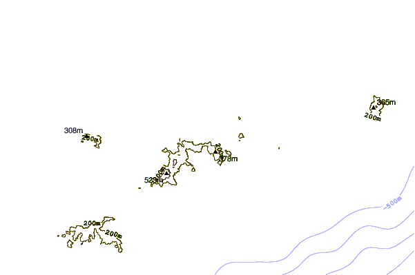
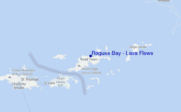
Utilizzare questa mappa sollievo per navigare Tortola surf breaks e stazioni di marea che si trovano nella zona diRogues Bay - Lava Flows
Altri surf breaks più vicini al Rogues Bay - Lava Flows:
(clicca sul nome del luogo per maggiori informazioni)- Closest località surf0 mi
- Second closest località surf1 mi
- Third closest località surf1 mi
- Fourth closest località surf1 mi
- Fifth closest località surf2 mi
Onda boe più vicina a Rogues Bay - Lava Flows:
- Closest Onda boa17 mi
- Second closest Onda boa58 mi
- Third closest Onda boa98 mi
- Fourth closest Onda boa132 mi
- Fifth closest Onda boa154 mi
Stazioni di marea più vicina alla Rogues Bay - Lava Flows:
- Closest marea stazioneRoad Town3 mi
- Second closest marea stazioneCoral Harbor, Saint Johns Island10 mi
- Third closest marea stazioneLameshur Bay, Saint Johns12 mi
- Fourth closest marea stazioneRedhook Bay, Saint Thomas Island19 mi
- Fifth closest marea stazioneBenner Bay, Saint Thomas19 mi
Airports
- The closest passenger airport to Rogues Bay - Lava Flows is Terrance B Lettsome International (Roadtown/beef Island) Airport (EIS) in Virgin Isl., 7 km (4 miles) away (directly).
- The second nearest airport to Rogues Bay - Lava Flows is Cyril E King (St. Thomas) Airport (STT), also in Virgin Isl., 41 km (25 miles) away.
- Third is Henry E Rohlsen (St. Criox Island) Airport (STX) in Virgin Isl., 86 km (53 miles) away.
- Diego Jimenez Torres (Fajardo) Airport (FAJ) in Puerto Rico is 112 km (70 miles) away.
- Roosevelt Roads Ns Airport (NRR), also in Puerto Rico is the fifth nearest airport to Rogues Bay - Lava Flows and is 112 km (70 miles) away.
- /breaks/Lava-Flows/forecasts/latest

 Nearest