
Left Point Surf Guide
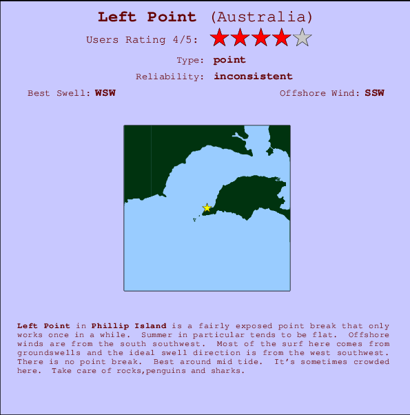
Left Point in Phillip Island is a sheltered point break that has unreliable waves. Summer in particular tends to be flat. The best wind direction is from the south southwest. Groundswells more frequent than windswells and the ideal swell angle is from the west southwest.The waves is a point break that peels left. Best around mid tide. When it's working here, it can get crowded. Watch out for rocks,penguins and sharks.
Left Point Spot Info
| Type: | Rating: | Reliability: | Todays Sea Temp*: |
|---|---|---|---|
| inconsistent | 13.7°C*ocean temperature recorded from satellite |
Surfing Left Point:
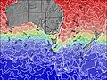
The best conditions reported for surf at Left Point occur when a West-southwest swell combines with an offshore wind direction from the South-southwest.

Previsioni Energia d'onda (Potenza): 12hrs


Left Point Surf:
Thursday, 23 July 2026, 05:06 Local time| Giovedì 23 | ||||
| 1AM | 4AM | 7AM | 10AM | |
| Wave (m) | ||||
| Periodo (s) | 11 | 13 | 14 | 14 |
| Vento (km/h) | ||||
| Stato del vento | cross- off |
cross- off |
cross- off |
cross- off |
- /breaks/Left-Point/forecasts/latest
Left Point Surf Guide
Left Point in Phillip Island is a sheltered point break that has unreliable waves. Summer in particular tends to be flat. The best wind direction is from the south southwest. Groundswells more frequent than windswells and the ideal swell angle is from the west southwest.The waves is a point break that peels left. Best around mid tide. When it's working here, it can get crowded. Watch out for rocks,penguins and sharks.
Left Point Spot Info
Type: Rating: Reliability: Todays Sea Temp*:  Point
Point 4
4inconsistent 13.7°C*ocean temperature recorded from satelliteSurfing Left Point:
The best conditions reported for surf at Left Point occur when a West-southwest swell combines with an offshore wind direction from the South-southwest.
Previsioni Energia d'onda (Potenza): 12hrs
Utilizzare la scheda di navigazione in alto per visualizzare Left Point temperatura del mare, Left Point fotografie, Left Point dettagliate previsioni onde, il vento e le previsioni meteo, Left Point webcam, vento corrente da VIC - Phillip Island stazioni meteo e Left Point previsioni marea. Il link Australia mappe maree apre l'immagine grande, che mostra Australia e dei mari circostanti. Queste mappe possono essere animate per mostrare le diverse componenti del moto ondoso, energia delle onde, periodo d'onda, altezza delle onde, insieme con le previsioni del vento e meteo, meteo corrente e osservazioni sullo stato del mare dal Australia onda-boe, le navi passanti e stazioni meteo costiere. Ciascuna delle pagine di previsioni per questo surf break rappresenta uno strumento di wavefinder globale e regionale per individuare le migliori condizioni di surf nella zona intorno Left Point.
Left Point Surf:
Thursday, 23 July 2026, 05:06 Local timeGiovedì 23 1AM 4AM 7AM 10AM Wave (m) Periodo (s) 11 13 14 14 Vento (km/h) Stato del vento cross-
offcross-
offcross-
offcross-
off- /breaks/Left-Point/forecasts/latest
- /breaks/Left-Point/forecasts/latest/six_day
Left Point Surf Guide
Left Point in Phillip Island is a sheltered point break that has unreliable waves. Summer in particular tends to be flat. The best wind direction is from the south southwest. Groundswells more frequent than windswells and the ideal swell angle is from the west southwest.The waves is a point break that peels left. Best around mid tide. When it's working here, it can get crowded. Watch out for rocks,penguins and sharks.
Left Point Spot Info
Type: Rating: Reliability: Todays Sea Temp*: Point4inconsistent 13.7°C*ocean temperature recorded from satelliteSurfing Left Point:
The best conditions reported for surf at Left Point occur when a West-southwest swell combines with an offshore wind direction from the South-southwest.
Previsioni Energia d'onda (Potenza): 12hrs
Utilizzare la scheda di navigazione in alto per visualizzare Left Point temperatura del mare, Left Point fotografie, Left Point dettagliate previsioni onde, il vento e le previsioni meteo, Left Point webcam, vento corrente da VIC - Phillip Island stazioni meteo e Left Point previsioni marea. Il link Australia mappe maree apre l'immagine grande, che mostra Australia e dei mari circostanti. Queste mappe possono essere animate per mostrare le diverse componenti del moto ondoso, energia delle onde, periodo d'onda, altezza delle onde, insieme con le previsioni del vento e meteo, meteo corrente e osservazioni sullo stato del mare dal Australia onda-boe, le navi passanti e stazioni meteo costiere. Ciascuna delle pagine di previsioni per questo surf break rappresenta uno strumento di wavefinder globale e regionale per individuare le migliori condizioni di surf nella zona intorno Left Point.
Left Point Surf:
Thursday, 23 July 2026, 05:06 Local timeGiovedì 23 1AM 4AM 7AM 10AM Wave (m) Periodo (s) 11 13 14 14 Vento (km/h) Stato del vento cross-
offcross-
offcross-
offcross-
off- /breaks/Left-Point/forecasts/latest
Left Point Surf Guide
Left Point in Phillip Island is a sheltered point break that has unreliable waves. Summer in particular tends to be flat. The best wind direction is from the south southwest. Groundswells more frequent than windswells and the ideal swell angle is from the west southwest.The waves is a point break that peels left. Best around mid tide. When it's working here, it can get crowded. Watch out for rocks,penguins and sharks.
Left Point Spot Info
Type: Rating: Reliability: Todays Sea Temp*: Point4inconsistent 13.7°C*ocean temperature recorded from satelliteSurfing Left Point:
The best conditions reported for surf at Left Point occur when a West-southwest swell combines with an offshore wind direction from the South-southwest.
Previsioni Energia d'onda (Potenza): 12hrs
Utilizzare la scheda di navigazione in alto per visualizzare Left Point temperatura del mare, Left Point fotografie, Left Point dettagliate previsioni onde, il vento e le previsioni meteo, Left Point webcam, vento corrente da VIC - Phillip Island stazioni meteo e Left Point previsioni marea. Il link Australia mappe maree apre l'immagine grande, che mostra Australia e dei mari circostanti. Queste mappe possono essere animate per mostrare le diverse componenti del moto ondoso, energia delle onde, periodo d'onda, altezza delle onde, insieme con le previsioni del vento e meteo, meteo corrente e osservazioni sullo stato del mare dal Australia onda-boe, le navi passanti e stazioni meteo costiere. Ciascuna delle pagine di previsioni per questo surf break rappresenta uno strumento di wavefinder globale e regionale per individuare le migliori condizioni di surf nella zona intorno Left Point.
Left Point Surf:
Thursday, 23 July 2026, 05:06 Local timeGiovedì 23 1AM 4AM 7AM 10AM Wave (m) Periodo (s) 11 13 14 14 Vento (km/h) Stato del vento cross-
offcross-
offcross-
offcross-
offTide Times:
Per Phillip Island, %{dist} %{km} da %{location}.
PROSSIMA È ALLE (ora locale) rimanente alta marea bassa marea Left Point Tide Times and Tide Chart
Live Weather:
At Rhyll, 16 km from Left Point.
wind obs. (7 kph from 110 degs) was rejected
(km/h)
no reportAir temperature
8.5°COverall Left Point Surf Consistency and Wind Distribution in Luglio
foto dall' album
Contorni: Strade e fiumi: seleziona un surf break dal menu 


Utilizzare questa mappa sollievo per navigare VIC - Phillip Island surf breaks e stazioni di marea che si trovano nella zona diLeft Point
Altri surf breaks più vicini al Left Point:
(clicca sul nome del luogo per maggiori informazioni)- Closest località surf0 mi
- Second closest località surf0 mi
- Third closest località surf1 mi
- Fourth closest località surf1 mi
- Fifth closest località surf1 mi
Onda boe più vicina a Left Point:
- Closest Onda boa250 mi
- Second closest Onda boa289 mi
- Third closest Onda boa347 mi
- Fourth closest Onda boa430 mi
- Fifth closest Onda boa479 mi
Stazioni di marea più vicina alla Left Point:
- Closest marea stazionePhillip Island6 mi
- Second closest marea stazioneStony Point11 mi
- Third closest marea stazioneWesternport11 mi
- Fourth closest marea stazioneHastings15 mi
- Fifth closest marea stazioneFrankston East26 mi
Airports
- The closest passenger airport to Left Point is Melbourne Moorabbin Airport (MBW) in Australia, 59 km (37 miles) away (directly).
- The second nearest airport to Left Point is Avalon Airport (AVV), also in Australia, 78 km (48 miles) away.
- Third is Melbourne Essendon Airport (MEB) in Australia, 89 km (55 miles) away.
- Melbourne International Airport (MEL) in Australia is 96 km (60 miles) away.
- Albury Airport (ABX), also in Australia is the fifth nearest airport to Left Point and is 316 km (196 miles) away.
- /breaks/Left-Point/forecasts/latest


 Nearest