
Previsioni:

Previsione a breve terminePioggia moderata (Totale 15mm), più pesante martedì pomeriggio. Very mild (Max 13°C martedì mattina, Min 7°C martedì notte). Venti in aumento (venti deboli da NNE martedì pomeriggio, bufere nelle prossimità da SW per mercoledì mattina). | ||||||||||||||||||||||
Martedì 28 | Mercoledì 29 | Giovedì 30 | ||||||||||||||||||||
7 AM | 10 AM | 1 PM | 4 PM | 7 PM | 10 PM | 1 AM | 4 AM | 7 AM | 10 AM | 1 PM | 4 PM | 7 PM | 10 PM | 1 AM | 4 AM | 7 AM | 10 AM | 1 PM | 4 PM | 7 PM | 10 PM | |
Mappa dell'altezza del moto ondoso |  |  |  | 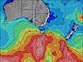 |  |  | 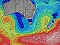 |  | ||||||||||||||
Onda Altezza (m) Direzione Periodo (s) | SSW 16 | SSW 14 | SSW 14 | SW 14 | SW 14 | SW 14 | SW 14 | SW 14 | SW 17 | SW 16 | SW 14 | SSW 12 | SSW 11 | SSW 10 | SSW 10 | SSW 13 | SSW 13 | SSW 13 | SSW 13 | SW 13 | SW 12 | SW 12 |
Grafico delle onde | ||||||||||||||||||||||
2874 | 2480 | 2250 | 1979 | 1979 | 2140 | 2085 | 1836 | 3621 | 4263 | 9267 | 6320 | 4294 | 3019 | 2313 | 3447 | 3210 | 2817 | 2431 | 1452 | 1290 | 1182 | |
Vento (km/h) | ||||||||||||||||||||||
Stato del vento onshore cross-onshore cross-shore cross-offshore offshore piatto | cross-off | cross-off | off | cross-off | off | cross-off | off | off | off | cross-off | cross | cross | cross | cross | cross-off | cross-off | cross-off | cross-off | cross-off | cross-off | cross-off | cross-off |
Alta Marea | 4:07PM0.76m | 4:39PM0.76m | 5:11PM0.74m | |||||||||||||||||||
Basso Marea | 1:15AM0.14m | 1:52AM0.15m | ||||||||||||||||||||
7:28 | — | — | — | — | — | — | — | 7:28 | — | — | — | — | — | — | — | 7:26 | — | — | — | — | — | |
— | — | — | 5:06 | — | — | — | — | — | — | — | 5:07 | — | — | — | — | — | — | — | 5:07 | — | — | |
mm | — | — | 1 | 2 | 2 | — | — | — | — | 1 | 2 | 1 | 1 | 1 | 1 | — | 1 | — | 1 | 1 | — | — |
Temp. °C | 12 | 13 | 12 | 11 | 11 | 8 | 8 | 7 | 7 | 9 | 8 | 8 | 8 | 8 | 9 | 8 | 10 | 10 | 9 | 10 | 10 | 10 |
Gelo °C | 5 | 7 | 8 | 8 | 6 | 4 | 4 | 3 | 3 | 1 | -5 | -4 | -3 | -2 | -1 | 2 | 1 | 2 | 3 | 3 | 5 | 5 |
Onda 1 Altezza (m) Direzione Periodo (s) | SSW 16 | SSW 14 | SSW 14 | SW 14 | SW 14 | SW 14 | SW 14 | SW 14 | SW 17 | SE 13 | SE 13 | SE 15 | SE 15 | SE 15 | SE 14 | SE 14 | SE 14 | SE 14 | SE 13 | SSE 8 | SSE 8 | SW 12 |
2874 | 2480 | 2250 | 1979 | 1979 | 2140 | 2085 | 1836 | 3621 | 27 | 27 | 33 | 54 | 54 | 53 | 51 | 51 | 65 | 88 | 250 | 176 | 1182 | |
Onda 2 Altezza (m) Direzione Periodo (s) | SE 14 | SE 14 | SE 14 | NE 8 | SE 14 | NE 8 | ESE 13 | SW 20 | SE 13 | SE 16 | SE 16 | — | — | — | — | ESE 14 | — | ESE 14 | ESE 13 | SE 13 | SE 14 | SSE 8 |
33 | 33 | 32 | 16 | 29 | 9 | 35 | 537 | 27 | 10 | 10 | — | — | — | — | 78 | — | 73 | 69 | 84 | 93 | 149 | |
Onda 3 Altezza (m) Direzione Periodo (s) | — | — | SE 14 | NE 4 | SE 13 | SE 13 | SE 13 | SE 13 | SE 16 | — | — | — | — | — | — | — | — | — | — | S 24 | S 24 | SE 14 |
— | — | 51 | 4 | 46 | 28 | 44 | 44 | 10 | — | — | — | — | — | — | — | — | — | — | 11 | 11 | 48 | |
onde vento Altezza (m) Direzione Periodo (s) | NNE 4 | NE 5 | NE 5 | N 3 | NE 8 | W 7 | — | — | — | SW 16 | SW 14 | SSW 12 | SSW 11 | SSW 10 | SSW 10 | SSW 13 | SSW 13 | SSW 13 | SSW 13 | SW 13 | SW 12 | — |
28 | 49 | 25 | 6 | 28 | 286 | — | — | — | 4263 | 9267 | 6320 | 4294 | 3019 | 2313 | 3447 | 3210 | 2817 | 2431 | 1452 | 1290 | — | |
Il più vicino Offshore or Glassy | ||||||||||||||||||||||
Distanza (km) | 78 | 78 | 627 | 6 | 6 | 6 | 6 | 6 | 6 | 96 | 733 | 1222 | 69 | 66 | 74 | 74 | 69 | 74 | 74 | 74 | 53 | 53 |
Migliori previsioni per le condizioni d'onda in East Coast of Tasmania | ||||||||||||||||||||||
Migliori previsioni per le condizioni d'onda in Australia | ||||||||||||||||||||||
Trova Onde Globale | ||||||||||||||||||||||
- Map Icons:
 Break
Break Live Wave Height (m)
 Live Wind Speed (km/h)
 Surf Rating (10 Max)
 Ocean Swells (m)
- Wind Speed (km/h)
Widget Free Surf-Forecast.com per il tuo sito
La relazione di surf / widget meteo è disponibile qui sotto per incorporare su siti esterni a titolo gratuito e fornisce una sintesi delle nostre Bruny Island - Mabel Bay previsione surf. Basta prendere il frammento di codice html da noi fornito e copiarlo nel proprio sito. È possibile scegliere la lingua preferita e unità metriche / imperiali per il feed delle previsioni surf per soddisfare le esigenze degli utenti del vostro sito .... Clicca qui per ottenere il codice.
 Nearest