
Previsioni:

Previsione a breve termineper lo più asciutto. Warm (Max 26°C Sabato mattina, Min 25°C Venerdì mattina). Principalmente venti freschi. | ||||||||||||||||||||||
Venerdì 17 | Sabato 18 | Domenica 19 | ||||||||||||||||||||
7 AM | 10 AM | 1 PM | 4 PM | 7 PM | 10 PM | 1 AM | 4 AM | 7 AM | 10 AM | 1 PM | 4 PM | 7 PM | 10 PM | 1 AM | 4 AM | 7 AM | 10 AM | 1 PM | 4 PM | 7 PM | 10 PM | |
Mappa dell'altezza del moto ondoso | 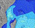 | 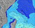 | 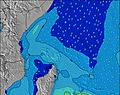 | 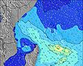 | 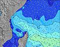 | 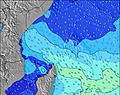 | 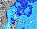 | 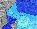 | ||||||||||||||
Onda Altezza (m) Direzione Periodo (s) | SE 9 | SE 9 | SE 9 | SE 9 | SE 9 | SE 8 | SE 8 | SE 9 | SE 9 | SE 9 | SE 8 | SE 7 | SE 7 | SE 7 | SE 7 | SE 7 | SE 8 | S 9 | SE 7 | SE 7 | SE 7 | SE 8 |
Grafico delle onde | ||||||||||||||||||||||
354 | 334 | 300 | 314 | 314 | 256 | 286 | 449 | 519 | 564 | 403 | 301 | 285 | 269 | 218 | 237 | 221 | 165 | 174 | 179 | 194 | 210 | |
Vento (km/h) | ||||||||||||||||||||||
Stato del vento onshore cross-onshore cross-shore cross-offshore offshore piatto | cross | cross | cross-on | cross | cross | cross | cross | cross | cross | cross-on | cross | cross | cross | cross | cross | cross | cross | cross | cross | cross | cross | cross |
Alta Marea | 6:47AM0.90m | 6:42PM1.22m | 7:32AM0.97m | 7:21PM1.09m | 8:18AM1.02m | 7:58PM0.95m | ||||||||||||||||
Basso Marea | 12:25PM0.18m | 1:22AM0.00m | 1:20PM0.24m | 1:54AM0.04m | 2:17PM0.32m | |||||||||||||||||
6:24 | — | — | — | — | — | — | 6:24 | — | — | — | — | — | — | — | 6:24 | — | — | — | — | — | — | |
— | — | — | 6:19 | — | — | — | — | — | — | — | 6:19 | — | — | — | — | — | — | — | 6:19 | — | — | |
mm | — | — | — | — | — | — | — | — | — | — | — | — | — | — | — | — | — | — | — | — | — | — |
Temp. °C | 25 | 25 | 25 | 25 | 25 | 25 | 25 | 25 | 25 | 25 | 26 | 26 | 26 | 25 | 25 | 25 | 25 | 25 | 25 | 25 | 25 | 25 |
Gelo °C | 25 | 25 | 25 | 25 | 25 | 24 | 24 | 23 | 23 | 24 | 25 | 25 | 25 | 23 | 24 | 24 | 24 | 23 | 24 | 23 | 24 | 24 |
Onda 1 Altezza (m) Direzione Periodo (s) | SE 9 | SE 9 | SE 9 | SE 9 | S 11 | S 10 | S 11 | SW 6 | SW 6 | S 20 | S 10 | S 9 | SSE 9 | SSE 8 | SE 7 | SSE 9 | SSE 9 | S 9 | SSE 9 | SSE 9 | S 14 | S 14 |
354 | 334 | 300 | 314 | 58 | 53 | 56 | 1 | 1 | 8 | 68 | 54 | 64 | 57 | 218 | 64 | 66 | 165 | 71 | 70 | 150 | 146 | |
Onda 2 Altezza (m) Direzione Periodo (s) | SSW 6 | SSW 6 | SSW 6 | S 11 | SW 6 | SSE 10 | SSE 10 | N 11 | S 21 | S 15 | S 19 | SSE 19 | SSE 18 | SSE 18 | SSE 9 | SSE 16 | S 16 | S 16 | S 16 | S 15 | SSE 9 | SSE 9 |
26 | 15 | 13 | 40 | 8 | 38 | 37 | 2 | 8 | 4 | 7 | 35 | 64 | 60 | 64 | 90 | 131 | 127 | 122 | 157 | 52 | 30 | |
Onda 3 Altezza (m) Direzione Periodo (s) | S 12 | S 12 | S 12 | SW 6 | SW 7 | SSW 6 | SW 6 | S 21 | N 11 | W 6 | S 15 | S 15 | SE 15 | SE 18 | SSE 17 | SE 16 | SE 17 | SE 16 | SE 16 | SE 16 | SE 15 | SE 15 |
46 | 44 | 42 | 8 | 2 | 3 | 2 | 9 | 2 | 1 | 4 | 4 | 9 | 13 | 58 | 43 | 44 | 40 | 62 | 61 | 60 | 55 | |
onde vento Altezza (m) Direzione Periodo (s) | — | — | — | — | SE 9 | SE 8 | SE 8 | SE 9 | SE 9 | SE 9 | SE 8 | SE 7 | SE 7 | SE 7 | — | SE 7 | SE 8 | ESE 8 | SE 7 | SE 7 | SE 7 | SE 8 |
— | — | — | — | 314 | 256 | 286 | 449 | 519 | 564 | 403 | 301 | 285 | 269 | — | 237 | 221 | 149 | 174 | 179 | 194 | 210 | |
Il più vicino Offshore or Glassy | ||||||||||||||||||||||
Distanza (km) | 1764 | 66 | 66 | 66 | 66 | 66 | 1783 | 1802 | 1764 | 1764 | 1749 | 1764 | 1764 | 66 | 1749 | 1749 | 1749 | 1749 | 1749 | 1749 | 1764 | 1759 |
Migliori previsioni per le condizioni d'onda in Marianne Island | ||||||||||||||||||||||
Migliori previsioni per le condizioni d'onda in Seychelles | ||||||||||||||||||||||
Trova Onde Globale | ||||||||||||||||||||||
- Map Icons:
 Break
Break Live Wave Height (m)
 Live Wind Speed (km/h)
 Surf Rating (10 Max)
 Ocean Swells (m)
- Wind Speed (km/h)
Widget Free Surf-Forecast.com per il tuo sito
La relazione di surf / widget meteo è disponibile qui sotto per incorporare su siti esterni a titolo gratuito e fornisce una sintesi delle nostre Marie Ann Island Leftovers previsione surf. Basta prendere il frammento di codice html da noi fornito e copiarlo nel proprio sito. È possibile scegliere la lingua preferita e unità metriche / imperiali per il feed delle previsioni surf per soddisfare le esigenze degli utenti del vostro sito .... Clicca qui per ottenere il codice.
 Nearest