
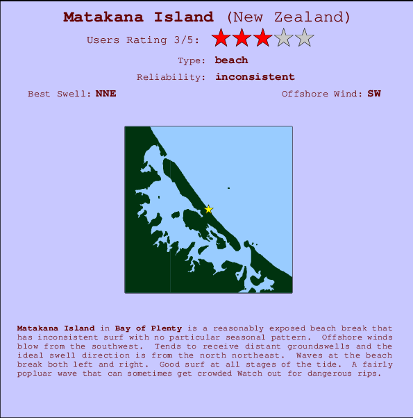
Matakana Island Surf Guide
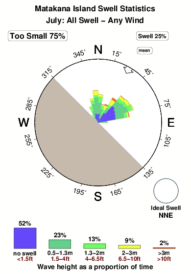
Matakana Island in Bay of Plenty is a quite exposed beach break that has inconsistent surf with no particular seasonal pattern. Offshore winds blow from the southwest. Most of the surf here comes from groundswells and the optimum swell angle is from the north northeast. Waves at the beach break both left and right. Good surf at all stages of the tide. Sometimes crowded. Watch out for dangerous rips.
Matakana Island Spot Info
| Type: | Rating: | Reliability: | Todays Sea Temp*: |
|---|---|---|---|
| inconsistent | 13.3°C*ocean temperature recorded from satellite |
Surfing Matakana Island:
The best conditions reported for surf at Matakana Island occur when a North-northeast swell combines with an offshore wind direction from the Southwest.

Previsioni Energia d'onda (Potenza): 12hrs


Matakana Island Surf:
Thursday, 16 July 2026, 23:55 Local time| Gio | Venerdì 17 | |||
| 9PM | 0AM | 3AM | 6AM | |
| Wave (m) | ||||
| Periodo (s) | 13 | 19 | 19 | 18 |
| Vento (km/h) | ||||
| Stato del vento | off | off | cross- off |
cross- off |
- /breaks/Matakana-Island/forecasts/latest
Matakana Island Surf Guide
Matakana Island in Bay of Plenty is a quite exposed beach break that has inconsistent surf with no particular seasonal pattern. Offshore winds blow from the southwest. Most of the surf here comes from groundswells and the optimum swell angle is from the north northeast. Waves at the beach break both left and right. Good surf at all stages of the tide. Sometimes crowded. Watch out for dangerous rips.
Matakana Island Spot Info
Type: Rating: Reliability: Todays Sea Temp*:  Beach
Beach 3
3inconsistent 13.3°C*ocean temperature recorded from satelliteSurfing Matakana Island:
The best conditions reported for surf at Matakana Island occur when a North-northeast swell combines with an offshore wind direction from the Southwest.
Previsioni Energia d'onda (Potenza): 12hrs
Utilizzare la scheda di navigazione in alto per visualizzare Matakana Island temperatura del mare, Matakana Island fotografie, Matakana Island dettagliate previsioni onde, il vento e le previsioni meteo, Matakana Island webcam, vento corrente da Bay of Plenty stazioni meteo e Matakana Island previsioni marea. Il link New Zealand mappe maree apre l'immagine grande, che mostra New Zealand e dei mari circostanti. Queste mappe possono essere animate per mostrare le diverse componenti del moto ondoso, energia delle onde, periodo d'onda, altezza delle onde, insieme con le previsioni del vento e meteo, meteo corrente e osservazioni sullo stato del mare dal New Zealand onda-boe, le navi passanti e stazioni meteo costiere. Ciascuna delle pagine di previsioni per questo surf break rappresenta uno strumento di wavefinder globale e regionale per individuare le migliori condizioni di surf nella zona intorno Matakana Island.
Matakana Island Surf:
Thursday, 16 July 2026, 23:55 Local timeGio Venerdì 17 9PM 0AM 3AM 6AM Wave (m) Periodo (s) 13 19 19 18 Vento (km/h) Stato del vento off off cross-
offcross-
off- /breaks/Matakana-Island/forecasts/latest
- /breaks/Matakana-Island/forecasts/latest/six_day
Matakana Island Surf Guide
Matakana Island in Bay of Plenty is a quite exposed beach break that has inconsistent surf with no particular seasonal pattern. Offshore winds blow from the southwest. Most of the surf here comes from groundswells and the optimum swell angle is from the north northeast. Waves at the beach break both left and right. Good surf at all stages of the tide. Sometimes crowded. Watch out for dangerous rips.
Matakana Island Spot Info
Type: Rating: Reliability: Todays Sea Temp*: Beach3inconsistent 13.3°C*ocean temperature recorded from satelliteSurfing Matakana Island:
The best conditions reported for surf at Matakana Island occur when a North-northeast swell combines with an offshore wind direction from the Southwest.
Previsioni Energia d'onda (Potenza): 12hrs
Utilizzare la scheda di navigazione in alto per visualizzare Matakana Island temperatura del mare, Matakana Island fotografie, Matakana Island dettagliate previsioni onde, il vento e le previsioni meteo, Matakana Island webcam, vento corrente da Bay of Plenty stazioni meteo e Matakana Island previsioni marea. Il link New Zealand mappe maree apre l'immagine grande, che mostra New Zealand e dei mari circostanti. Queste mappe possono essere animate per mostrare le diverse componenti del moto ondoso, energia delle onde, periodo d'onda, altezza delle onde, insieme con le previsioni del vento e meteo, meteo corrente e osservazioni sullo stato del mare dal New Zealand onda-boe, le navi passanti e stazioni meteo costiere. Ciascuna delle pagine di previsioni per questo surf break rappresenta uno strumento di wavefinder globale e regionale per individuare le migliori condizioni di surf nella zona intorno Matakana Island.
Matakana Island Surf:
Thursday, 16 July 2026, 23:55 Local timeGio Venerdì 17 9PM 0AM 3AM 6AM Wave (m) Periodo (s) 13 19 19 18 Vento (km/h) Stato del vento off off cross-
offcross-
off- /breaks/Matakana-Island/forecasts/latest
Matakana Island Surf Guide
Matakana Island in Bay of Plenty is a quite exposed beach break that has inconsistent surf with no particular seasonal pattern. Offshore winds blow from the southwest. Most of the surf here comes from groundswells and the optimum swell angle is from the north northeast. Waves at the beach break both left and right. Good surf at all stages of the tide. Sometimes crowded. Watch out for dangerous rips.
Matakana Island Spot Info
Type: Rating: Reliability: Todays Sea Temp*: Beach3inconsistent 13.3°C*ocean temperature recorded from satelliteSurfing Matakana Island:
The best conditions reported for surf at Matakana Island occur when a North-northeast swell combines with an offshore wind direction from the Southwest.
Previsioni Energia d'onda (Potenza): 12hrs
Utilizzare la scheda di navigazione in alto per visualizzare Matakana Island temperatura del mare, Matakana Island fotografie, Matakana Island dettagliate previsioni onde, il vento e le previsioni meteo, Matakana Island webcam, vento corrente da Bay of Plenty stazioni meteo e Matakana Island previsioni marea. Il link New Zealand mappe maree apre l'immagine grande, che mostra New Zealand e dei mari circostanti. Queste mappe possono essere animate per mostrare le diverse componenti del moto ondoso, energia delle onde, periodo d'onda, altezza delle onde, insieme con le previsioni del vento e meteo, meteo corrente e osservazioni sullo stato del mare dal New Zealand onda-boe, le navi passanti e stazioni meteo costiere. Ciascuna delle pagine di previsioni per questo surf break rappresenta uno strumento di wavefinder globale e regionale per individuare le migliori condizioni di surf nella zona intorno Matakana Island.
Matakana Island Surf:
Thursday, 16 July 2026, 23:55 Local timeGio Venerdì 17 9PM 0AM 3AM 6AM Wave (m) Periodo (s) 13 19 19 18 Vento (km/h) Stato del vento off off cross-
offcross-
offTide Times:
A Matakana Island (0 km).
PROSSIMA È ALLE (ora locale) rimanente alta marea bassa marea Matakana Island Tide Times and Tide Chart
Live Weather:
At Matakana Island, 5 km from Matakana Island.
calm
(km/h)
DryAir temperature
12°COverall Matakana Island Surf Consistency and Wind Distribution in Luglio
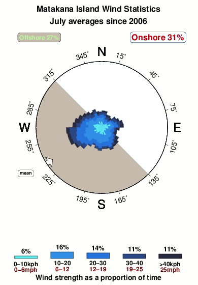


Wind stats for Matakana Island: see the variation in direction and stength by month.
foto dall' album
Contorni: Strade e fiumi: seleziona un surf break dal menu 


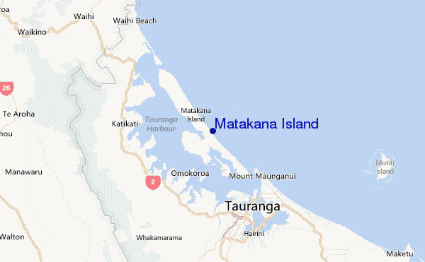
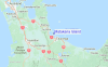
Utilizzare questa mappa sollievo per navigare Bay of Plenty surf breaks e stazioni di marea che si trovano nella zona diMatakana Island
Altri surf breaks più vicini al Matakana Island:
(clicca sul nome del luogo per maggiori informazioni)- Closest località surf7 mi
- Second closest località surf7 mi
- Third closest località surf8 mi
- Fourth closest località surf9 mi
- Fifth closest località surf9 mi
Onda boe più vicina a Matakana Island:
- Closest Onda boa30 mi
- Second closest Onda boa144 mi
- Third closest Onda boa269 mi
- Fourth closest Onda boa274 mi
- Fifth closest Onda boa296 mi
Stazioni di marea più vicina alla Matakana Island:
- Closest marea stazioneTauranga7 mi
- Second closest marea stazioneSlipper Island37 mi
- Third closest marea stazioneTairua42 mi
- Fourth closest marea stazioneRocky Point (Thames)45 mi
- Fifth closest marea stazioneMoutohora (Whale) Island53 mi
Airports
- The closest passenger airport to Matakana Island is Tauranga Airport (TRG) in New Zealand, 15 km (9 miles) away (directly).
- The second nearest airport to Matakana Island is Rotorua Airport (ROT), also in New Zealand, 63 km (39 miles) away.
- Third is Hamilton Airport (HLZ) in New Zealand, 74 km (46 miles) away.
- Whakatane Airport (WHK) in New Zealand is 83 km (52 miles) away.
- Auckland International Airport (AKL), also in New Zealand is the fifth nearest airport to Matakana Island and is 130 km (81 miles) away.
- /breaks/Matakana-Island/forecasts/latest
 Nearest