
Mount Maunganui Surf Guide
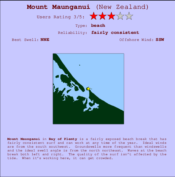
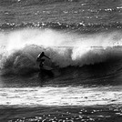
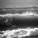
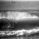
Mount Maunguni in Bay of Plenty is a reasonably exposed beach break that has fairly consistent surf and can work at any time of the year. Offshore winds blow from the south southwest. Tends to receive distant groundswells and the best swell direction is from the north northeast. The beach break provides left and right handers. The quality of the surf isn't affected by the tide. When it's working here, it can get crowded. Take care of .
Mount Maunganui Spot Info
| Type: | Rating: | Reliability: | Todays Sea Temp*: |
|---|---|---|---|
| fairly consistent | 14.1°C*ocean temperature recorded from satellite |
Surfing Mount Maunganui:
The best conditions reported for surf at Mount Maunganui occur when a North-northeast swell combines with an offshore wind direction from the South-southwest.

Previsioni Energia d'onda (Potenza): 12hrs


Mount Maunganui Surf:
Thursday, 16 July 2026, 13:04 Local time| Giovedì 16 | ||||
| 9AM | 12PM | 3PM | 6PM | |
| Wave (m) | ||||
| Periodo (s) | 12 | 12 | 12 | 13 |
| Vento (km/h) | ||||
| Stato del vento | cross- off |
cross- off |
cross- off |
cross- off |
- /breaks/Mount-Maunguni/forecasts/latest

Mount Maunganui Surf Guide
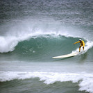
Mount Maunguni in Bay of Plenty is a reasonably exposed beach break that has fairly consistent surf and can work at any time of the year. Offshore winds blow from the south southwest. Tends to receive distant groundswells and the best swell direction is from the north northeast. The beach break provides left and right handers. The quality of the surf isn't affected by the tide. When it's working here, it can get crowded. Take care of .
Mount Maunganui Spot Info
Type: Rating: Reliability: Todays Sea Temp*:  Beach
Beach 3
3fairly consistent 14.1°C*ocean temperature recorded from satelliteSurfing Mount Maunganui:
The best conditions reported for surf at Mount Maunganui occur when a North-northeast swell combines with an offshore wind direction from the South-southwest.
Previsioni Energia d'onda (Potenza): 12hrs
Utilizzare la scheda di navigazione in alto per visualizzare Mount Maunganui temperatura del mare, Mount Maunganui fotografie, Mount Maunganui dettagliate previsioni onde, il vento e le previsioni meteo, Mount Maunganui webcam, vento corrente da Bay of Plenty stazioni meteo e Mount Maunganui previsioni marea. Il link New Zealand mappe maree apre l'immagine grande, che mostra New Zealand e dei mari circostanti. Queste mappe possono essere animate per mostrare le diverse componenti del moto ondoso, energia delle onde, periodo d'onda, altezza delle onde, insieme con le previsioni del vento e meteo, meteo corrente e osservazioni sullo stato del mare dal New Zealand onda-boe, le navi passanti e stazioni meteo costiere. Ciascuna delle pagine di previsioni per questo surf break rappresenta uno strumento di wavefinder globale e regionale per individuare le migliori condizioni di surf nella zona intorno Mount Maunganui.
Mount Maunganui Surf:
Thursday, 16 July 2026, 13:04 Local timeGiovedì 16 9AM 12PM 3PM 6PM Wave (m) Periodo (s) 12 12 12 13 Vento (km/h) Stato del vento cross-
offcross-
offcross-
offcross-
off- /breaks/Mount-Maunguni/forecasts/latest
- /breaks/Mount-Maunguni/forecasts/latest/six_day
Mount Maunganui Surf Guide
Mount Maunguni in Bay of Plenty is a reasonably exposed beach break that has fairly consistent surf and can work at any time of the year. Offshore winds blow from the south southwest. Tends to receive distant groundswells and the best swell direction is from the north northeast. The beach break provides left and right handers. The quality of the surf isn't affected by the tide. When it's working here, it can get crowded. Take care of .
Mount Maunganui Spot Info
Type: Rating: Reliability: Todays Sea Temp*: Beach3fairly consistent 14.1°C*ocean temperature recorded from satelliteSurfing Mount Maunganui:
The best conditions reported for surf at Mount Maunganui occur when a North-northeast swell combines with an offshore wind direction from the South-southwest.
Previsioni Energia d'onda (Potenza): 12hrs
Utilizzare la scheda di navigazione in alto per visualizzare Mount Maunganui temperatura del mare, Mount Maunganui fotografie, Mount Maunganui dettagliate previsioni onde, il vento e le previsioni meteo, Mount Maunganui webcam, vento corrente da Bay of Plenty stazioni meteo e Mount Maunganui previsioni marea. Il link New Zealand mappe maree apre l'immagine grande, che mostra New Zealand e dei mari circostanti. Queste mappe possono essere animate per mostrare le diverse componenti del moto ondoso, energia delle onde, periodo d'onda, altezza delle onde, insieme con le previsioni del vento e meteo, meteo corrente e osservazioni sullo stato del mare dal New Zealand onda-boe, le navi passanti e stazioni meteo costiere. Ciascuna delle pagine di previsioni per questo surf break rappresenta uno strumento di wavefinder globale e regionale per individuare le migliori condizioni di surf nella zona intorno Mount Maunganui.
Mount Maunganui Surf:
Thursday, 16 July 2026, 13:04 Local timeGiovedì 16 9AM 12PM 3PM 6PM Wave (m) Periodo (s) 12 12 12 13 Vento (km/h) Stato del vento cross-
offcross-
offcross-
offcross-
off- /breaks/Mount-Maunguni/forecasts/latest
Mount Maunganui Surf Guide
Mount Maunguni in Bay of Plenty is a reasonably exposed beach break that has fairly consistent surf and can work at any time of the year. Offshore winds blow from the south southwest. Tends to receive distant groundswells and the best swell direction is from the north northeast. The beach break provides left and right handers. The quality of the surf isn't affected by the tide. When it's working here, it can get crowded. Take care of .
Mount Maunganui Spot Info
Type: Rating: Reliability: Todays Sea Temp*: Beach3fairly consistent 14.1°C*ocean temperature recorded from satelliteSurfing Mount Maunganui:
The best conditions reported for surf at Mount Maunganui occur when a North-northeast swell combines with an offshore wind direction from the South-southwest.
Previsioni Energia d'onda (Potenza): 12hrs
Utilizzare la scheda di navigazione in alto per visualizzare Mount Maunganui temperatura del mare, Mount Maunganui fotografie, Mount Maunganui dettagliate previsioni onde, il vento e le previsioni meteo, Mount Maunganui webcam, vento corrente da Bay of Plenty stazioni meteo e Mount Maunganui previsioni marea. Il link New Zealand mappe maree apre l'immagine grande, che mostra New Zealand e dei mari circostanti. Queste mappe possono essere animate per mostrare le diverse componenti del moto ondoso, energia delle onde, periodo d'onda, altezza delle onde, insieme con le previsioni del vento e meteo, meteo corrente e osservazioni sullo stato del mare dal New Zealand onda-boe, le navi passanti e stazioni meteo costiere. Ciascuna delle pagine di previsioni per questo surf break rappresenta uno strumento di wavefinder globale e regionale per individuare le migliori condizioni di surf nella zona intorno Mount Maunganui.
Mount Maunganui Surf:
Thursday, 16 July 2026, 13:04 Local timeGiovedì 16 9AM 12PM 3PM 6PM Wave (m) Periodo (s) 12 12 12 13 Vento (km/h) Stato del vento cross-
offcross-
offcross-
offcross-
offTide Times:
Per Tauranga, New Zealand, %{dist} %{km} da %{location}.
PROSSIMA È ALLE (ora locale) rimanente alta marea bassa marea Mount Maunganui Tide Times and Tide Chart
Live Weather:
At Pilot Bay, 1 km from Mount Maunganui.
light winds from the SW
(km/h)
DryAir temperature
15.5°COverall Mount Maunganui Surf Consistency and Wind Distribution in Luglio


Wind stats for Mount Maunganui: see the variation in direction and stength by month.
foto dall' album
Contorni: Strade e fiumi: seleziona un surf break dal menu 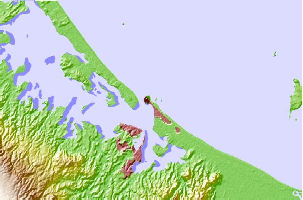
Utilizzare questa mappa sollievo per navigare Bay of Plenty surf breaks e stazioni di marea che si trovano nella zona diMount Maunganui
Altri surf breaks più vicini al Mount Maunganui:
(clicca sul nome del luogo per maggiori informazioni)- Closest località surf0 mi
- Second closest località surf2 mi
- Third closest località surf2 mi
- Fourth closest località surf7 mi
- Fifth closest località surf7 mi
Onda boe più vicina a Mount Maunganui:
- Closest Onda boa24 mi
- Second closest Onda boa151 mi
- Third closest Onda boa267 mi
- Fourth closest Onda boa274 mi
- Fifth closest Onda boa295 mi
Stazioni di marea più vicina alla Mount Maunganui:
- Closest marea stazioneTauranga1 mi
- Second closest marea stazioneSlipper Island42 mi
- Third closest marea stazioneMoutohora (Whale) Island47 mi
- Fourth closest marea stazioneTairua47 mi
- Fifth closest marea stazioneWhakatane50 mi
Airports
- The closest passenger airport to Mount Maunganui is Tauranga Airport (TRG) in New Zealand, 5 km (3 miles) away (directly).
- The second nearest airport to Mount Maunganui is Rotorua Airport (ROT), also in New Zealand, 55 km (34 miles) away.
- Third is Whakatane Airport (WHK) in New Zealand, 72 km (45 miles) away.
- Hamilton Airport (HLZ) in New Zealand is 79 km (49 miles) away.
- Taupo Airport (TUO), also in New Zealand is the fifth nearest airport to Mount Maunganui and is 124 km (77 miles) away.
- /breaks/Mount-Maunguni/forecasts/latest
 Nearest