
Previsioni:

Previsione a breve terminepioggia leggera (Totale 3mm), per lo più che cade mercoledì mattina. Very mild (Max 15°C martedì mattina, Min 10°C mercoledì notte). Vento sarà generalmente leggero. | ||||||||||||||||||||||
Lunedì 20 | Martedì 21 | Mercoledì 22 | ||||||||||||||||||||
6 AM | 9 AM | 12 PM | 3 PM | 6 PM | 9 PM | 12 AM | 3 AM | 6 AM | 9 AM | 12 PM | 3 PM | 6 PM | 9 PM | 12 AM | 3 AM | 6 AM | 9 AM | 12 PM | 3 PM | 6 PM | 9 PM | |
Mappa dell'altezza del moto ondoso | 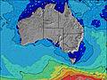 | 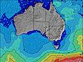 | 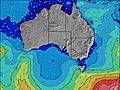 | 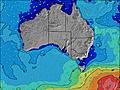 | 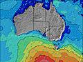 | 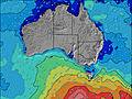 | 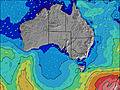 | 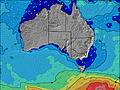 | ||||||||||||||
Onda Altezza (m) Direzione Periodo (s) | SW 16 | SSW 16 | SW 15 | SW 15 | SW 15 | SW 15 | SW 14 | SW 14 | SW 13 | SSW 13 | SW 13 | SW 13 | SW 13 | SW 12 | SSW 12 | SW 12 | SW 12 | SW 12 | SW 13 | SW 12 | SW 11 | SSW 11 |
Grafico delle onde | ||||||||||||||||||||||
587 | 519 | 429 | 489 | 623 | 881 | 1016 | 920 | 867 | 796 | 700 | 689 | 585 | 549 | 488 | 463 | 551 | 469 | 700 | 1077 | 1046 | 955 | |
Vento (km/h) | ||||||||||||||||||||||
Stato del vento onshore cross-onshore cross-shore cross-offshore offshore piatto | cross-off | cross-off | cross-off | cross-off | off | off | off | cross-off | off | cross-off | cross-off | cross-off | cross-off | cross-off | cross-off | cross-off | cross | cross-off | cross-on | cross-on | cross-on | cross-on |
Alta Marea | 5:50AM0.54m | 4:48PM0.59m | 6:24AM0.60m | 4:40PM0.51m | 7:03AM0.62m | 4:00PM0.46m | ||||||||||||||||
Basso Marea | 11:08AM0.29m | 11:30PM0.06m | 11:54AM0.36m | 11:32PM0.05m | 12:53PM0.43m | |||||||||||||||||
7:18 | — | — | — | — | — | — | — | 7:18 | — | — | — | — | — | — | — | 7:18 | — | — | — | — | — | |
— | — | — | 5:22 | — | — | — | — | — | — | — | 5:22 | — | — | — | — | — | — | — | 5:23 | — | — | |
mm | — | — | — | — | — | — | — | — | — | — | — | — | — | — | — | — | — | — | 1 | 1 | — | 1 |
Temp. °C | 14 | 14 | 14 | 14 | 14 | 14 | 14 | 14 | 13 | 14 | 15 | 15 | 14 | 14 | 13 | 13 | 12 | 13 | 13 | 13 | 11 | 11 |
Gelo °C | 11 | 11 | 11 | 11 | 11 | 12 | 12 | 12 | 11 | 12 | 12 | 12 | 12 | 11 | 9 | 9 | 10 | 10 | 10 | 8 | 7 | 6 |
Onda 1 Altezza (m) Direzione Periodo (s) | SW 16 | SSW 16 | SW 15 | SW 15 | SW 15 | SW 15 | SW 14 | SW 14 | SW 13 | SSW 13 | SW 13 | SW 13 | SW 13 | SW 12 | SSW 12 | SW 12 | SW 12 | SW 12 | SW 13 | — | — | SSW 14 |
587 | 519 | 429 | 489 | 623 | 881 | 1016 | 920 | 867 | 796 | 700 | 689 | 585 | 549 | 488 | 463 | 551 | 469 | 700 | — | — | 452 | |
Onda 2 Altezza (m) Direzione Periodo (s) | S 10 | SW 10 | S 10 | S 10 | S 10 | S 10 | — | SSW 14 | — | — | — | — | — | — | — | — | — | SSW 15 | — | — | — | — |
53 | 50 | 31 | 17 | 7 | 7 | — | 668 | — | — | — | — | — | — | — | — | — | 72 | — | — | — | — | |
Onda 3 Altezza (m) Direzione Periodo (s) | — | — | — | — | — | — | — | — | — | — | — | — | — | — | — | — | — | — | — | — | — | — |
— | — | — | — | — | — | — | — | — | — | — | — | — | — | — | — | — | — | — | — | — | — | |
onde vento Altezza (m) Direzione Periodo (s) | — | NNW 3 | NW 3 | WNW 4 | WNW 4 | — | — | — | — | — | — | — | WNW 3 | WNW 4 | NW 2 | W 3 | WSW 7 | — | — | SW 12 | SW 11 | SSW 11 |
— | 4 | 4 | 5 | 6 | — | — | — | — | — | — | — | 5 | 5 | 2 | 5 | 99 | — | — | 1077 | 1046 | 955 | |
Il più vicino Offshore or Glassy | ||||||||||||||||||||||
Distanza (km) | 0 | 0 | 0 | 0 | 0 | 0 | 0 | 0 | 0 | 0 | 0 | 0 | 0 | 0 | 2 | 2 | 2 | 576 | 2 | 584 | 141 | 170 |
Migliori previsioni per le condizioni d'onda in South Australia - East Coast | ||||||||||||||||||||||
Migliori previsioni per le condizioni d'onda in Australia | ||||||||||||||||||||||
Trova Onde Globale | ||||||||||||||||||||||
- Map Icons:
 Break
Break Live Wave Height (m)
 Live Wind Speed (km/h)
 Surf Rating (10 Max)
 Ocean Swells (m)
- Wind Speed (km/h)
Widget Free Surf-Forecast.com per il tuo sito
La relazione di surf / widget meteo è disponibile qui sotto per incorporare su siti esterni a titolo gratuito e fornisce una sintesi delle nostre Middleton Beach previsione surf. Basta prendere il frammento di codice html da noi fornito e copiarlo nel proprio sito. È possibile scegliere la lingua preferita e unità metriche / imperiali per il feed delle previsioni surf per soddisfare le esigenze degli utenti del vostro sito .... Clicca qui per ottenere il codice.
 Nearest