
Previsioni:

Previsione a breve terminePioggia moderata (Totale 15mm), più pesante giovedì notte. Very mild (Max 17°C Sabato mattina, Min 15°C giovedì pomeriggio). Vento sarà generalmente leggero. | ||||||||||||||||||||||||
Gio 16 | Venerdì 17 | Sabato 18 | Dom 19 | |||||||||||||||||||||
1 PM | 4 PM | 7 PM | 10 PM | 1 AM | 4 AM | 7 AM | 10 AM | 1 PM | 4 PM | 7 PM | 10 PM | 1 AM | 4 AM | 7 AM | 10 AM | 1 PM | 4 PM | 7 PM | 10 PM | 1 AM | 4 AM | 7 AM | 10 AM | |
Mappa dell'altezza del moto ondoso |  |  |  |  |  |  |  |  |  | 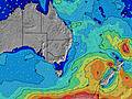 | ||||||||||||||
Onda Altezza (m) Direzione Periodo (s) | S 8 | S 8 | S 7 | E 6 | ESE 6 | ESE 6 | E 6 | E 6 | E 6 | E 8 | E 8 | E 7 | ESE 7 | E 7 | E 7 | E 7 | E 7 | E 7 | E 7 | E 8 | E 8 | E 10 | ENE 10 | ENE 11 |
Grafico delle onde | ||||||||||||||||||||||||
0 | 0 | 0 | 24 | 31 | 31 | 40 | 33 | 33 | 89 | 89 | 87 | 111 | 82 | 88 | 88 | 113 | 123 | 130 | 169 | 187 | 450 | 634 | 769 | |
Vento (km/h) | ||||||||||||||||||||||||
Stato del vento onshore cross-onshore cross-shore cross-offshore offshore piatto | cross-on | cross-on | cross-on | on | on | on | glassy | glassy | on | on | cross-on | cross-on | cross-on | cross-on | cross-on | on | cross-on | on | on | on | on | on | on | on |
Alta Marea | 9:42PM1.77m | 10:33AM1.22m | 10:29PM1.65m | 11:21AM1.24m | 11:16PM1.49m | |||||||||||||||||||
Basso Marea | 3:16PM0.24m | 4:28AM-0.03m | 4:08PM0.28m | 5:11AM0.04m | 5:02PM0.34m | 5:51AM0.13m | ||||||||||||||||||
— | — | — | — | — | 6:56 | — | — | — | — | — | — | — | 6:56 | — | — | — | — | — | — | — | 6:54 | — | — | |
— | 5:04 | — | — | — | — | — | — | — | 5:05 | — | — | — | — | — | — | — | 5:05 | — | — | — | — | — | 5:06 | |
mm | 1 | 1 | 2 | 3 | 3 | 2 | 1 | 1 | 1 | 1 | — | — | — | — | — | — | — | — | — | — | — | — | — | — |
Temp. °C | 15 | 16 | 15 | 15 | 15 | 15 | 15 | 15 | 16 | 16 | 16 | 15 | 15 | 15 | 16 | 17 | 17 | 17 | 16 | 17 | 17 | 16 | 16 | 16 |
Gelo °C | 9 | 11 | 11 | 13 | 14 | 14 | 14 | 14 | 15 | 15 | 15 | 14 | 14 | 13 | 14 | 14 | 14 | 13 | 13 | 14 | 14 | 12 | 14 | 14 |
Onda 1 Altezza (m) Direzione Periodo (s) | S 18 | S 18 | S 18 | S 7 | S 7 | S 7 | S 7 | S 6 | S 6 | E 8 | E 8 | E 7 | E 7 | E 7 | E 7 | E 7 | E 7 | E 7 | E 7 | E 8 | E 8 | E 10 | ENE 10 | ENE 11 |
25 | 25 | 25 | 303 | 188 | 131 | 86 | 78 | 47 | 89 | 89 | 87 | 85 | 82 | 88 | 88 | 113 | 123 | 130 | 169 | 187 | 450 | 634 | 769 | |
Onda 2 Altezza (m) Direzione Periodo (s) | — | — | S 13 | E 6 | S 18 | ESE 6 | E 8 | E 6 | E 6 | S 6 | S 6 | S 5 | S 10 | S 10 | S 10 | S 10 | S 10 | S 10 | S 10 | S 9 | ENE 10 | S 18 | S 18 | S 17 |
— | — | 13 | 24 | 26 | 31 | 19 | 33 | 33 | 32 | 31 | 21 | 54 | 53 | 98 | 69 | 68 | 66 | 44 | 40 | 59 | 99 | 96 | 147 | |
Onda 3 Altezza (m) Direzione Periodo (s) | — | — | SSW 14 | S 18 | E 8 | E 8 | S 18 | E 8 | E 8 | S 8 | S 8 | S 8 | S 5 | S 21 | S 21 | S 21 | S 20 | S 20 | S 20 | S 19 | S 9 | S 8 | S 8 | S 8 |
— | — | 36 | 25 | 5 | 11 | 25 | 19 | 29 | 21 | 21 | 22 | 13 | 36 | 35 | 34 | 32 | 33 | 67 | 65 | 24 | 22 | 21 | 21 | |
onde vento Altezza (m) Direzione Periodo (s) | S 8 | S 8 | S 7 | — | ESE 6 | — | E 6 | — | — | — | — | — | ESE 7 | S 5 | — | — | — | — | — | — | — | — | — | — |
731 | 718 | 483 | — | 31 | — | 40 | — | — | — | — | — | 111 | 8 | — | — | — | — | — | — | — | — | — | — | |
Il più vicino Offshore or Glassy | ||||||||||||||||||||||||
Distanza (km) | 121 | 97 | 51 | 2 | 2 | 2 | 0 | 0 | 2 | 2 | 2 | 2 | 2 | 2 | 2 | 2 | 2 | 85 | 2 | 2 | 2 | 2 | 2 | 2 |
Migliori previsioni per le condizioni d'onda in Sydney North Coast | ||||||||||||||||||||||||
Migliori previsioni per le condizioni d'onda in Australia | ||||||||||||||||||||||||
Trova Onde Globale | ||||||||||||||||||||||||
- Map Icons:
 Break
Break Live Wave Height (m)
 Live Wind Speed (km/h)
 Surf Rating (10 Max)
 Ocean Swells (m)
- Wind Speed (km/h)
Widget Free Surf-Forecast.com per il tuo sito
La relazione di surf / widget meteo è disponibile qui sotto per incorporare su siti esterni a titolo gratuito e fornisce una sintesi delle nostre Mona Vale-The Basin previsione surf. Basta prendere il frammento di codice html da noi fornito e copiarlo nel proprio sito. È possibile scegliere la lingua preferita e unità metriche / imperiali per il feed delle previsioni surf per soddisfare le esigenze degli utenti del vostro sito .... Clicca qui per ottenere il codice.
 Nearest