
Previsioni:

Previsione a breve terminepioggia leggera (Totale 2mm), per lo più che cade Sabato notte. Very mild (Max 17°C Domenica mattina, Min 13°C Domenica mattina). Venti decrescenti (venti freschi da O Sabato mattina, calma per lunedì notte). | |||||||||||||||||||||||
Sabato 18 | Domenica 19 | Lunedì 20 | |||||||||||||||||||||
5 AM | 8 AM | 11 AM | 2 PM | 5 PM | 8 PM | 11 PM | 2 AM | 5 AM | 8 AM | 11 AM | 2 PM | 5 PM | 8 PM | 11 PM | 2 AM | 5 AM | 8 AM | 11 AM | 2 PM | 5 PM | 8 PM | 11 PM | |
Mappa dell'altezza del moto ondoso |  |  | 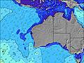 |  | 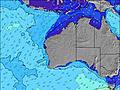 | 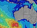 |  | 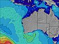 | 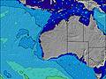 | ||||||||||||||
Onda Altezza (m) Direzione Periodo (s) | W 14 | WSW 13 | WSW 13 | WSW 13 | WSW 15 | WSW 16 | WSW 16 | WSW 15 | WSW 15 | WSW 14 | WSW 14 | WSW 14 | WSW 14 | WSW 13 | WSW 13 | WSW 13 | WSW 13 | WSW 13 | WSW 13 | WSW 13 | WSW 13 | WSW 13 | WSW 14 |
Grafico delle onde | |||||||||||||||||||||||
3596 | 4493 | 3759 | 4162 | 6675 | 6533 | 5700 | 4774 | 3835 | 3199 | 2673 | 2171 | 1744 | 1556 | 1306 | 1060 | 943 | 928 | 822 | 737 | 620 | 546 | 672 | |
Vento (km/h) | |||||||||||||||||||||||
Stato del vento onshore cross-onshore cross-shore cross-offshore offshore piatto | cross-on | on | on | cross-on | on | on | on | cross-on | on | on | on | on | on | glassy | glassy | cross-off | cross-off | cross-off | cross-off | on | cross-on | cross | glassy |
Alta Marea | 11:02AM0.51m | 2:34AM0.38m | 10:05AM0.43m | 2:50AM0.44m | 9:10AM0.39m | ||||||||||||||||||
Basso Marea | 6:41PM0.22m | 5:19AM0.36m | 6:15PM0.22m | 7:01AM0.38m | 6:01PM0.21m | ||||||||||||||||||
7:13 | — | — | — | — | — | — | — | 7:13 | — | — | — | — | — | — | — | 7:13 | — | — | — | — | — | — | |
— | — | — | — | 5:31 | — | — | — | — | — | — | — | 5:31 | — | — | — | — | — | — | — | 5:32 | — | — | |
mm | 1 | — | — | — | — | — | — | — | 1 | 1 | — | — | — | — | — | — | — | — | — | — | — | — | — |
Temp. °C | 17 | 16 | 16 | 16 | 16 | 16 | 16 | 16 | 16 | 16 | 16 | 17 | 17 | 16 | 15 | 14 | 13 | 13 | 14 | 15 | 15 | 15 | 15 |
Gelo °C | 10 | 9 | 10 | 10 | 12 | 12 | 12 | 13 | 13 | 12 | 13 | 14 | 14 | 14 | 14 | 12 | 11 | 11 | 12 | 13 | 12 | 12 | 14 |
Onda 1 Altezza (m) Direzione Periodo (s) | — | — | WSW 16 | WSW 13 | WSW 15 | WSW 16 | WSW 16 | WSW 15 | WSW 15 | WSW 14 | WSW 14 | WSW 14 | WSW 14 | WSW 13 | WSW 13 | WSW 13 | WSW 13 | WSW 13 | WSW 13 | WSW 13 | WSW 13 | WSW 13 | WSW 14 |
— | — | 1360 | 4162 | 6675 | 6533 | 5700 | 4774 | 3835 | 3199 | 2673 | 2171 | 1744 | 1556 | 1306 | 1060 | 943 | 928 | 822 | 737 | 620 | 546 | 672 | |
Onda 2 Altezza (m) Direzione Periodo (s) | — | — | — | WSW 17 | — | — | — | — | WSW 15 | — | W 13 | — | — | — | — | — | — | — | — | SW 16 | SW 16 | WSW 16 | — |
— | — | — | 1514 | — | — | — | — | 1275 | — | 55 | — | — | — | — | — | — | — | — | 67 | 66 | 102 | — | |
Onda 3 Altezza (m) Direzione Periodo (s) | — | — | — | — | — | — | — | — | — | — | — | — | — | — | — | — | — | — | — | — | — | — | — |
— | — | — | — | — | — | — | — | — | — | — | — | — | — | — | — | — | — | — | — | — | — | — | |
onde vento Altezza (m) Direzione Periodo (s) | W 14 | WSW 13 | WSW 13 | — | — | — | — | — | — | — | — | — | — | — | — | — | — | — | — | — | — | — | — |
3596 | 4493 | 3759 | — | — | — | — | — | — | — | — | — | — | — | — | — | — | — | — | — | — | — | — | |
Il più vicino Offshore or Glassy | |||||||||||||||||||||||
Distanza (km) | 1627 | 898 | 478 | 673 | 416 | 292 | 292 | 292 | 292 | 292 | 203 | 203 | 167 | 0 | 0 | 0 | 0 | 0 | 0 | 389 | 86 | 21 | 0 |
Migliori previsioni per le condizioni d'onda in Perth City Coast | |||||||||||||||||||||||
Migliori previsioni per le condizioni d'onda in Australia | |||||||||||||||||||||||
Trova Onde Globale | |||||||||||||||||||||||
- Map Icons:
 Break
Break Live Wave Height (m)
 Live Wind Speed (km/h)
 Surf Rating (10 Max)
 Ocean Swells (m)
- Wind Speed (km/h)
Widget Free Surf-Forecast.com per il tuo sito
La relazione di surf / widget meteo è disponibile qui sotto per incorporare su siti esterni a titolo gratuito e fornisce una sintesi delle nostre Mullaloo previsione surf. Basta prendere il frammento di codice html da noi fornito e copiarlo nel proprio sito. È possibile scegliere la lingua preferita e unità metriche / imperiali per il feed delle previsioni surf per soddisfare le esigenze degli utenti del vostro sito .... Clicca qui per ottenere il codice.
 Nearest