
Previsioni:

Aggiornamento in hr min s Forecast update imminent
Previsione a breve terminePioggia abbondante (Totale 28mm), più pesante durante mercoledì notte. Very mild (Max 15°C mercoledì mattina, Min 7°C giovedì notte). Venti in aumento (calma mercoledì notte, raffiche di vento da NW per giovedì mattina). | ||||||||||||||||||||||||
Mar 30 | Mercoledì 1 | Giovedì 2 | Ven 3 | |||||||||||||||||||||
1 PM | 4 PM | 7 PM | 10 PM | 1 AM | 4 AM | 7 AM | 10 AM | 1 PM | 4 PM | 7 PM | 10 PM | 1 AM | 4 AM | 7 AM | 10 AM | 1 PM | 4 PM | 7 PM | 10 PM | 1 AM | 4 AM | 7 AM | 10 AM | |
Mappa dell'altezza del moto ondoso |  |  |  |  |  |  |  |  |  | 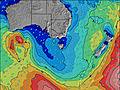 | ||||||||||||||
Onda Altezza (m) Direzione Periodo (s) | NE 8 | NE 8 | NE 9 | NE 9 | NE 9 | NE 9 | S 14 | NE 9 | S 10 | S 13 | S 13 | NE 8 | S 13 | NE 8 | S 13 | S 13 | S 13 | S 13 | S 13 | NE 9 | S 15 | NE 10 | NE 10 | NE 10 |
Grafico delle onde | ||||||||||||||||||||||||
475 | 619 | 827 | 808 | 885 | 783 | 4 | 492 | 2 | 3 | 4 | 250 | 3 | 291 | 3 | 3 | 3 | 3 | 3 | 258 | 4 | 213 | 245 | 230 | |
Vento (km/h) | ||||||||||||||||||||||||
Stato del vento onshore cross-onshore cross-shore cross-offshore offshore piatto | cross-off | cross-off | off | off | cross-off | off | off | off | off | off | off | glassy | cross-off | cross-off | off | off | off | off | off | off | off | off | off | off |
Alta Marea | 8:26PM1.33m | 9:55AM0.92m | 9:05PM1.32m | 10:35AM0.93m | 9:44PM1.29m | |||||||||||||||||||
Basso Marea | 3:36AM0.20m | 2:41PM0.60m | 4:14AM0.19m | 3:24PM0.60m | 4:51AM0.19m | |||||||||||||||||||
— | — | — | — | — | — | 7:33 | — | — | — | — | — | — | — | 7:33 | — | — | — | — | — | — | — | 7:33 | — | |
— | 4:46 | — | — | — | — | — | — | — | 4:46 | — | — | — | — | — | — | — | 4:46 | — | — | — | — | — | 4:47 | |
mm | — | 1 | 1 | 1 | 2 | — | — | — | — | — | — | — | 1 | 5 | 5 | 3 | 2 | 3 | — | 3 | — | 1 | — | — |
Temp. °C | 13 | 14 | 14 | 14 | 13 | 12 | 12 | 13 | 15 | 14 | 11 | 11 | 12 | 12 | 12 | 12 | 12 | 11 | 10 | 9 | 9 | 8 | 7 | 9 |
Gelo °C | 12 | 13 | 11 | 11 | 11 | 9 | 9 | 10 | 11 | 11 | 9 | 10 | 10 | 6 | 6 | 6 | 4 | 5 | 5 | 4 | 4 | 3 | 2 | 5 |
Onda 1 Altezza (m) Direzione Periodo (s) | S 11 | NE 8 | NE 9 | NE 9 | NE 9 | NE 9 | NNE 9 | NE 9 | NNE 9 | NNE 8 | NE 8 | NE 8 | S 13 | S 13 | NNE 8 | NNE 8 | S 13 | S 13 | NE 10 | NE 9 | NNE 9 | NE 10 | NE 10 | NE 10 |
10 | 619 | 827 | 808 | 885 | 783 | 651 | 492 | 429 | 322 | 281 | 250 | 3 | 4 | 459 | 708 | 3 | 3 | 384 | 258 | 333 | 213 | 245 | 230 | |
Onda 2 Altezza (m) Direzione Periodo (s) | S 11 | S 11 | S 11 | S 11 | S 10 | S 10 | S 10 | S 10 | S 10 | S 9 | S 13 | S 13 | — | — | S 13 | S 13 | — | S 13 | S 13 | S 13 | E 9 | E 9 | S 20 | SE 19 |
10 | 10 | 9 | 9 | 8 | 2 | 2 | 2 | 2 | 2 | 4 | 4 | — | — | 3 | 3 | — | 3 | 3 | 3 | 2 | 2 | 7 | 14 | |
Onda 3 Altezza (m) Direzione Periodo (s) | — | — | — | — | — | S 14 | S 14 | S 13 | — | S 13 | S 9 | — | — | — | — | — | — | — | — | — | S 15 | S 13 | — | N 18 |
— | — | — | — | — | 4 | 4 | 4 | — | 3 | 2 | — | — | — | — | — | — | — | — | — | 4 | 4 | — | 6 | |
onde vento Altezza (m) Direzione Periodo (s) | NE 8 | NNE 8 | NNE 9 | — | — | — | NW 4 | NW 4 | NNE 9 | NNE 8 | — | — | NNE 8 | NE 8 | NNE 8 | NW 5 | N 9 | N 9 | N 9 | N 9 | NW 5 | NNW 5 | NNW 6 | NNW 6 |
475 | 903 | 1060 | — | — | — | 24 | 14 | 554 | 422 | — | — | 300 | 291 | 730 | 114 | 1350 | 919 | 764 | 614 | 43 | 111 | 151 | 161 | |
Il più vicino Offshore or Glassy | ||||||||||||||||||||||||
Distanza (km) | 168 | 182 | 107 | 107 | 143 | 107 | 107 | 143 | 113 | 107 | 107 | 168 | 182 | 182 | 107 | 168 | 191 | 168 | 182 | 182 | 182 | 182 | 143 | 107 |
Migliori previsioni per le condizioni d'onda in East Coast of Tasmania | ||||||||||||||||||||||||
Migliori previsioni per le condizioni d'onda in Australia | ||||||||||||||||||||||||
Trova Onde Globale | ||||||||||||||||||||||||
- Map Icons:
 Break
Break Live Wave Height (m)
 Live Wind Speed (km/h)
 Surf Rating (10 Max)
 Ocean Swells (m)
- Wind Speed (km/h)
Widget Free Surf-Forecast.com per il tuo sito
La relazione di surf / widget meteo è disponibile qui sotto per incorporare su siti esterni a titolo gratuito e fornisce una sintesi delle nostre Perons Beach previsione surf. Basta prendere il frammento di codice html da noi fornito e copiarlo nel proprio sito. È possibile scegliere la lingua preferita e unità metriche / imperiali per il feed delle previsioni surf per soddisfare le esigenze degli utenti del vostro sito .... Clicca qui per ottenere il codice.
 Nearest