
Previsioni:

Previsione a breve terminepioggia leggera (Totale 6mm), per lo più che cade Lunedì notte. Very mild (Max 12°C martedì pomeriggio, Min 7°C Lunedì notte). Vento sarà generalmente leggero. | ||||||||||||||||||
Lun 3 | Martedì 4 | Mercoledì 5 | ||||||||||||||||
7 PM | 10 PM | 1 AM | 4 AM | 7 AM | 10 AM | 1 PM | 4 PM | 7 PM | 10 PM | 1 AM | 4 AM | 7 AM | 10 AM | 1 PM | 4 PM | 7 PM | 10 PM | |
Mappa dell'altezza del moto ondoso |  |  |  |  |  | 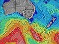 |  | |||||||||||
Onda Altezza (m) Direzione Periodo (s) | SW 14 | SW 13 | WSW 13 | SW 12 | SW 12 | SW 12 | SW 12 | SW 12 | SW 10 | SSW 10 | SW 10 | SSW 10 | SW 9 | SW 14 | SW 10 | SW 14 | SW 13 | SSW 13 |
Grafico delle onde | ||||||||||||||||||
549 | 398 | 2402 | 361 | 437 | 409 | 1121 | 644 | 1309 | 277 | 577 | 157 | 376 | 1107 | 316 | 810 | 1014 | 313 | |
Vento (km/h) | ||||||||||||||||||
Stato del vento onshore cross-onshore cross-shore cross-offshore offshore piatto | off | off | off | off | off | off | cross-off | cross-off | off | cross-off | off | off | off | cross-off | cross-off | cross-off | off | off |
Alta Marea | 3:11AM1.69m | 3:22PM1.87m | 3:50AM1.75m | 3:48PM1.85m | ||||||||||||||
Basso Marea | 9:12PM0.45m | 9:09AM0.45m | 9:40PM0.35m | 9:45AM0.51m | ||||||||||||||
— | — | — | — | 7:20 | — | — | — | — | — | — | — | 7:20 | — | — | — | — | — | |
— | — | — | — | — | — | — | 5:36 | — | — | — | — | — | — | — | 5:36 | — | — | |
mm | — | 1 | 1 | — | — | — | 1 | 1 | 1 | — | — | — | — | — | — | 1 | — | — |
Temp. °C | 11 | 9 | 9 | 7 | 8 | 9 | 11 | 12 | 10 | 10 | 10 | 9 | 9 | 10 | 12 | 12 | 11 | 11 |
Gelo °C | 7 | 5 | 4 | 2 | 2 | 3 | 5 | 7 | 6 | 6 | 6 | 5 | 5 | 6 | 8 | 8 | 8 | 8 |
Onda 1 Altezza (m) Direzione Periodo (s) | SW 14 | SW 13 | SW 13 | SW 12 | SW 12 | SW 12 | SW 12 | SW 16 | SSW 10 | SSW 10 | SW 10 | SSW 10 | SSW 10 | SSW 15 | SSW 9 | SSW 9 | SSW 14 | SSW 13 |
549 | 398 | 352 | 361 | 437 | 409 | 503 | 119 | 314 | 277 | 229 | 157 | 161 | 455 | 111 | 121 | 396 | 313 | |
Onda 2 Altezza (m) Direzione Periodo (s) | — | SW 18 | WSW 13 | SW 17 | SW 16 | SW 16 | SW 16 | S 16 | SW 12 | SW 15 | SW 15 | SW 20 | SW 20 | SW 20 | SW 15 | SW 14 | SW 18 | SW 18 |
— | 80 | 120 | 147 | 95 | 67 | 90 | 5 | 108 | 56 | 54 | 101 | 186 | 98 | 174 | 167 | 114 | 112 | |
Onda 3 Altezza (m) Direzione Periodo (s) | — | S 18 | SW 17 | SW 13 | SW 17 | N 4 | — | — | SW 15 | SSW 12 | SW 21 | SW 15 | SW 13 | SW 11 | SW 19 | SW 18 | — | S 17 |
— | 6 | 148 | 46 | 100 | 2 | — | — | 59 | 15 | 109 | 54 | 40 | 61 | 95 | 166 | — | 6 | |
onde vento Altezza (m) Direzione Periodo (s) | NW 4 | WNW 2 | WSW 13 | NW 2 | WNW 3 | WNW 3 | SW 12 | SW 12 | SW 10 | — | SW 10 | — | SW 9 | SW 14 | SW 10 | SW 14 | SW 13 | — |
3 | 1 | 2402 | 2 | 3 | 3 | 1121 | 644 | 1309 | — | 577 | — | 376 | 1107 | 316 | 810 | 1014 | — | |
Il più vicino Offshore or Glassy | ||||||||||||||||||
Distanza (km) | 0 | 0 | 0 | 0 | 0 | 10 | 22 | 22 | 0 | 5 | 0 | 0 | 0 | 5 | 5 | 5 | 0 | 0 |
Migliori previsioni per le condizioni d'onda in Torquay | ||||||||||||||||||
Migliori previsioni per le condizioni d'onda in Australia | ||||||||||||||||||
Trova Onde Globale | ||||||||||||||||||
- Map Icons:
 Break
Break Live Wave Height (m)
 Live Wind Speed (km/h)
 Surf Rating (10 Max)
 Ocean Swells (m)
- Wind Speed (km/h)
Widget Free Surf-Forecast.com per il tuo sito
La relazione di surf / widget meteo è disponibile qui sotto per incorporare su siti esterni a titolo gratuito e fornisce una sintesi delle nostre Point Impossible previsione surf. Basta prendere il frammento di codice html da noi fornito e copiarlo nel proprio sito. È possibile scegliere la lingua preferita e unità metriche / imperiali per il feed delle previsioni surf per soddisfare le esigenze degli utenti del vostro sito .... Clicca qui per ottenere il codice.
 Nearest