
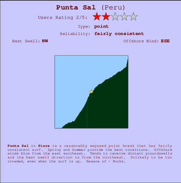
Punta Sal Surf Guide
Punta Sal in Piura is a fairly exposed point break that has pretty consitent surf. Spring and Summer provide the best conditions. Works best in offshore winds from the east southeast. Clean groundswells prevail and the best swell direction is from the northwest. Rarely crowded here. Hazards include - Rocks.
Punta Sal Spot Info
| Type: | Rating: | Reliability: | Todays Sea Temp*: |
|---|---|---|---|
| fairly consistent | 24.3°C*ocean temperature recorded from satellite |
Surfing Punta Sal:
The best conditions reported for surf at Punta Sal occur when a Northwest swell combines with an offshore wind direction from the East-southeast.

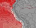
Previsioni Energia d'onda (Potenza): 12hrs


Punta Sal Surf:
Saturday, 18 July 2026, 04:25 Local time| Sabato 18 | ||||
| 4AM | 7AM | 10AM | 1PM | |
| Wave (m) | ||||
| Periodo (s) | 12 | 12 | 12 | 12 |
| Vento (km/h) | ||||
| Stato del vento | cross | glass | on | on |
- /breaks/Punta-Sal/forecasts/latest
Punta Sal Surf Guide
Punta Sal in Piura is a fairly exposed point break that has pretty consitent surf. Spring and Summer provide the best conditions. Works best in offshore winds from the east southeast. Clean groundswells prevail and the best swell direction is from the northwest. Rarely crowded here. Hazards include - Rocks.
Punta Sal Spot Info
Type: Rating: Reliability: Todays Sea Temp*:  Point
Point 2
2fairly consistent 24.3°C*ocean temperature recorded from satelliteSurfing Punta Sal:
The best conditions reported for surf at Punta Sal occur when a Northwest swell combines with an offshore wind direction from the East-southeast.
Previsioni Energia d'onda (Potenza): 12hrs
Utilizzare la scheda di navigazione in alto per visualizzare Punta Sal temperatura del mare, Punta Sal fotografie, Punta Sal dettagliate previsioni onde, il vento e le previsioni meteo, Punta Sal webcam, vento corrente da Piura stazioni meteo e Punta Sal previsioni marea. Il link Peru mappe maree apre l'immagine grande, che mostra Peru e dei mari circostanti. Queste mappe possono essere animate per mostrare le diverse componenti del moto ondoso, energia delle onde, periodo d'onda, altezza delle onde, insieme con le previsioni del vento e meteo, meteo corrente e osservazioni sullo stato del mare dal Peru onda-boe, le navi passanti e stazioni meteo costiere. Ciascuna delle pagine di previsioni per questo surf break rappresenta uno strumento di wavefinder globale e regionale per individuare le migliori condizioni di surf nella zona intorno Punta Sal.
Punta Sal Surf:
Saturday, 18 July 2026, 04:25 Local timeSabato 18 4AM 7AM 10AM 1PM Wave (m) Periodo (s) 12 12 12 12 Vento (km/h) Stato del vento cross glass on on - /breaks/Punta-Sal/forecasts/latest
- /breaks/Punta-Sal/forecasts/latest/six_day
Punta Sal Surf Guide
Punta Sal in Piura is a fairly exposed point break that has pretty consitent surf. Spring and Summer provide the best conditions. Works best in offshore winds from the east southeast. Clean groundswells prevail and the best swell direction is from the northwest. Rarely crowded here. Hazards include - Rocks.
Punta Sal Spot Info
Type: Rating: Reliability: Todays Sea Temp*: Point2fairly consistent 24.3°C*ocean temperature recorded from satelliteSurfing Punta Sal:
The best conditions reported for surf at Punta Sal occur when a Northwest swell combines with an offshore wind direction from the East-southeast.
Previsioni Energia d'onda (Potenza): 12hrs
Utilizzare la scheda di navigazione in alto per visualizzare Punta Sal temperatura del mare, Punta Sal fotografie, Punta Sal dettagliate previsioni onde, il vento e le previsioni meteo, Punta Sal webcam, vento corrente da Piura stazioni meteo e Punta Sal previsioni marea. Il link Peru mappe maree apre l'immagine grande, che mostra Peru e dei mari circostanti. Queste mappe possono essere animate per mostrare le diverse componenti del moto ondoso, energia delle onde, periodo d'onda, altezza delle onde, insieme con le previsioni del vento e meteo, meteo corrente e osservazioni sullo stato del mare dal Peru onda-boe, le navi passanti e stazioni meteo costiere. Ciascuna delle pagine di previsioni per questo surf break rappresenta uno strumento di wavefinder globale e regionale per individuare le migliori condizioni di surf nella zona intorno Punta Sal.
Punta Sal Surf:
Saturday, 18 July 2026, 04:25 Local timeSabato 18 4AM 7AM 10AM 1PM Wave (m) Periodo (s) 12 12 12 12 Vento (km/h) Stato del vento cross glass on on - /breaks/Punta-Sal/forecasts/latest
Punta Sal Surf Guide
Punta Sal in Piura is a fairly exposed point break that has pretty consitent surf. Spring and Summer provide the best conditions. Works best in offshore winds from the east southeast. Clean groundswells prevail and the best swell direction is from the northwest. Rarely crowded here. Hazards include - Rocks.
Punta Sal Spot Info
Type: Rating: Reliability: Todays Sea Temp*: Point2fairly consistent 24.3°C*ocean temperature recorded from satelliteSurfing Punta Sal:
The best conditions reported for surf at Punta Sal occur when a Northwest swell combines with an offshore wind direction from the East-southeast.
Previsioni Energia d'onda (Potenza): 12hrs
Utilizzare la scheda di navigazione in alto per visualizzare Punta Sal temperatura del mare, Punta Sal fotografie, Punta Sal dettagliate previsioni onde, il vento e le previsioni meteo, Punta Sal webcam, vento corrente da Piura stazioni meteo e Punta Sal previsioni marea. Il link Peru mappe maree apre l'immagine grande, che mostra Peru e dei mari circostanti. Queste mappe possono essere animate per mostrare le diverse componenti del moto ondoso, energia delle onde, periodo d'onda, altezza delle onde, insieme con le previsioni del vento e meteo, meteo corrente e osservazioni sullo stato del mare dal Peru onda-boe, le navi passanti e stazioni meteo costiere. Ciascuna delle pagine di previsioni per questo surf break rappresenta uno strumento di wavefinder globale e regionale per individuare le migliori condizioni di surf nella zona intorno Punta Sal.
Punta Sal Surf:
Saturday, 18 July 2026, 04:25 Local timeSabato 18 4AM 7AM 10AM 1PM Wave (m) Periodo (s) 12 12 12 12 Vento (km/h) Stato del vento cross glass on on Tide Times:
Per Cancas, %{dist} %{km} da %{location}.
PROSSIMA È ALLE (ora locale) rimanente alta marea bassa marea Punta Sal Tide Times and Tide Chart
Live Weather:
At Piura/Capitán FAP Guillermo Concha Iberico International Airport, 139 km from Punta Sal.
light winds from the S
(km/h)Air temperature
Q1013°COverall Punta Sal Surf Consistency and Wind Distribution in Luglio
foto dall' album
Contorni: Strade e fiumi: seleziona un surf break dal menu 


Utilizzare questa mappa sollievo per navigare Piura surf breaks e stazioni di marea che si trovano nella zona diPunta Sal
Altri surf breaks più vicini al Punta Sal:
(clicca sul nome del luogo per maggiori informazioni)- Closest località surf2 mi
- Second closest località surf7 mi
- Third closest località surf10 mi
- Fourth closest località surf17 mi
- Fifth closest località surf21 mi
Onda boe più vicina a Punta Sal:
- Closest Onda boa1103 mi
- Second closest Onda boa1439 mi
- Third closest Onda boa1672 mi
- Fourth closest Onda boa1804 mi
- Fifth closest Onda boa1805 mi
Stazioni di marea più vicina alla Punta Sal:
- Closest marea stazioneMancora10 mi
- Second closest marea stazioneZorritos30 mi
- Third closest marea stazioneTalara47 mi
- Fourth closest marea stazioneTumbes47 mi
- Fifth closest marea stazioneSalinera Colan73 mi
Airports
- The closest passenger airport to Punta Sal is Capitan Montes (Talara) Airport (TYL) in Peru, 73 km (45 miles) away (directly).
- The second nearest airport to Punta Sal is Pedro Canga (Tumbes) Airport (TBP), also in Peru, 82 km (51 miles) away.
- Third is General Serrano (Machala) Airport (MCH) in Ecuador, 138 km (86 miles) away.
- Capitan Concha (Piura) Airport (PIU) in Peru is 142 km (88 miles) away.
- General Ulpiano Paez (Salinas) Airport (SNC) in Ecuador is the fifth nearest airport to Punta Sal and is 197 km (122 miles) away.
- /breaks/Punta-Sal/forecasts/latest


 Nearest