
Previsioni:

Previsione a breve terminepioggia leggera (Totale 4mm), per lo più che cade Lunedì notte. Very mild (Max 15°C Domenica mattina, Min 10°C martedì pomeriggio). Venti in aumento (venti deboli da ONO Domenica mattina, raffiche di vento da NW per lunedì pomeriggio). | ||||||||||||||||||||||||
Domenica 26 | Lunedì 27 | Martedì 28 | ||||||||||||||||||||||
12 AM | 3 AM | 6 AM | 9 AM | 12 PM | 3 PM | 6 PM | 9 PM | 12 AM | 3 AM | 6 AM | 9 AM | 12 PM | 3 PM | 6 PM | 9 PM | 12 AM | 3 AM | 6 AM | 9 AM | 12 PM | 3 PM | 6 PM | 9 PM | |
Mappa dell'altezza del moto ondoso |  | 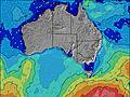 | 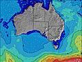 | 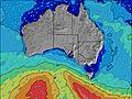 | 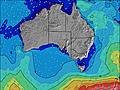 | 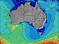 | 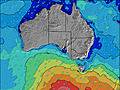 | 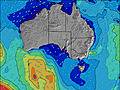 | 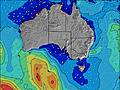 | |||||||||||||||
Onda Altezza (m) Direzione Periodo (s) | SW 12 | SW 11 | SW 11 | SW 11 | SW 11 | SW 11 | SW 11 | SW 11 | SW 11 | WSW 11 | SW 13 | SW 13 | NW 7 | WNW 9 | W 10 | W 11 | W 11 | W 10 | W 12 | WSW 12 | WSW 10 | SW 14 | SW 14 | SW 15 |
Grafico delle onde | ||||||||||||||||||||||||
1470 | 1302 | 1172 | 1092 | 1092 | 981 | 930 | 794 | 851 | 700 | 1599 | 1137 | 821 | 2467 | 5015 | 4055 | 2770 | 2407 | 3657 | 3435 | 2409 | 9426 | 9327 | 14918 | |
Vento (km/h) | ||||||||||||||||||||||||
Stato del vento onshore cross-onshore cross-shore cross-offshore offshore piatto | cross-on | cross-on | on | on | cross-on | cross-on | cross-on | cross-on | cross | cross | cross | cross | cross-on | cross-on | cross-on | on | on | on | on | on | cross-on | cross-on | cross-on | cross-on |
Alta Marea | 12:37PM0.76m | 2:21AM0.16m | 1:04PM0.80m | 1:25AM0.18m | 1:29PM0.84m | |||||||||||||||||||
Basso Marea | 10:33PM0.11m | 9:59PM0.12m | 3:35AM0.16m | 9:34PM0.13m | 5:13AM0.13m | 9:24PM0.14m | ||||||||||||||||||
— | — | 7:24 | — | — | — | — | — | — | — | 7:24 | — | — | — | — | — | — | — | 7:22 | — | — | — | — | — | |
— | — | — | — | — | 5:34 | — | — | — | — | — | — | — | 5:35 | — | — | — | — | — | — | — | 5:36 | — | — | |
mm | — | — | — | — | — | — | — | — | — | — | — | — | — | — | — | — | — | 1 | — | — | 1 | — | — | — |
Temp. °C | 14 | 14 | 14 | 14 | 15 | 15 | 14 | 14 | 13 | 13 | 14 | 15 | 15 | 14 | 14 | 14 | 14 | 14 | 13 | 12 | 11 | 11 | 10 | 12 |
Gelo °C | 11 | 11 | 12 | 12 | 12 | 11 | 11 | 11 | 9 | 9 | 8 | 8 | 6 | 5 | 7 | 7 | 8 | 7 | 5 | 4 | 1 | 2 | 1 | 5 |
Onda 1 Altezza (m) Direzione Periodo (s) | SW 12 | SW 11 | SW 11 | SW 11 | SW 11 | SW 11 | SW 11 | SW 11 | SW 11 | WSW 11 | SW 13 | SW 13 | SW 11 | SW 12 | — | SW 15 | SW 15 | SW 14 | SW 16 | SW 15 | SW 15 | SE 16 | SE 16 | WSW 13 |
1470 | 1302 | 1172 | 1092 | 1092 | 981 | 930 | 794 | 851 | 700 | 1599 | 1137 | 821 | 465 | — | 492 | 447 | 1006 | 1087 | 1434 | 1983 | 10 | 10 | 184 | |
Onda 2 Altezza (m) Direzione Periodo (s) | SW 16 | SW 16 | SW 16 | SSE 11 | SSE 11 | SW 15 | SW 15 | SW 15 | SW 15 | SW 14 | SSE 10 | S 10 | S 10 | SW 15 | — | — | W 16 | SE 18 | SE 15 | SE 15 | SE 17 | — | — | — |
67 | 66 | 67 | 42 | 39 | 139 | 215 | 305 | 266 | 478 | 18 | 17 | 7 | 223 | — | — | 254 | 12 | 8 | 8 | 11 | — | — | — | |
Onda 3 Altezza (m) Direzione Periodo (s) | SSE 12 | S 12 | S 12 | WSW 16 | WSW 15 | SSE 11 | SSE 11 | SSE 10 | SSE 10 | SSE 10 | — | S 14 | S 14 | S 10 | — | — | SE 18 | — | S 18 | S 18 | — | — | — | — |
29 | 11 | 26 | 103 | 42 | 38 | 37 | 35 | 34 | 32 | — | 4 | 4 | 7 | — | — | 13 | — | 6 | 6 | — | — | — | — | |
onde vento Altezza (m) Direzione Periodo (s) | — | — | — | — | — | — | — | — | — | NNW 4 | NNW 4 | NW 6 | NW 7 | WNW 9 | W 10 | W 11 | W 11 | W 10 | W 12 | WSW 12 | WSW 10 | SW 14 | SW 14 | SW 15 |
— | — | — | — | — | — | — | — | — | 10 | 47 | 356 | 821 | 2467 | 5015 | 4055 | 2770 | 2407 | 3657 | 3435 | 2409 | 9426 | 9327 | 14918 | |
Il più vicino Offshore or Glassy | ||||||||||||||||||||||||
Distanza (km) | 60 | 60 | 47 | 19 | 78 | 47 | 19 | 19 | 19 | 19 | 19 | 181 | 442 | 620 | 186 | 184 | 181 | 181 | 709 | 511 | 1030 | 1036 | 705 | 1203 |
Migliori previsioni per le condizioni d'onda in Kangaroo Island | ||||||||||||||||||||||||
Migliori previsioni per le condizioni d'onda in Australia | ||||||||||||||||||||||||
Trova Onde Globale | ||||||||||||||||||||||||
- Map Icons:
 Break
Break Live Wave Height (m)
 Live Wind Speed (km/h)
 Surf Rating (10 Max)
 Ocean Swells (m)
- Wind Speed (km/h)
Widget Free Surf-Forecast.com per il tuo sito
La relazione di surf / widget meteo è disponibile qui sotto per incorporare su siti esterni a titolo gratuito e fornisce una sintesi delle nostre Sandy Creek previsione surf. Basta prendere il frammento di codice html da noi fornito e copiarlo nel proprio sito. È possibile scegliere la lingua preferita e unità metriche / imperiali per il feed delle previsioni surf per soddisfare le esigenze degli utenti del vostro sito .... Clicca qui per ottenere il codice.
 Nearest