
Previsioni:

Previsione a breve terminePioggia moderata (Totale 12mm), più pesante mercoledì pomeriggio. Very mild (Max 13°C mercoledì mattina, Min 8°C mercoledì notte). Principalmente venti freschi. | ||||||||||||||||||||||
Mercoledì 22 | Giovedì 23 | Venerdì 24 | ||||||||||||||||||||
7 AM | 10 AM | 1 PM | 4 PM | 7 PM | 10 PM | 1 AM | 4 AM | 7 AM | 10 AM | 1 PM | 4 PM | 7 PM | 10 PM | 1 AM | 4 AM | 7 AM | 10 AM | 1 PM | 4 PM | 7 PM | 10 PM | |
Mappa dell'altezza del moto ondoso |  |  |  | 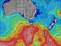 |  |  | 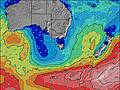 |  | ||||||||||||||
Onda Altezza (m) Direzione Periodo (s) | SW 12 | SW 12 | SW 12 | WSW 12 | SW 11 | SW 11 | SW 13 | SW 14 | SW 14 | SW 14 | SW 14 | SW 14 | SW 14 | SW 15 | SW 16 | SW 15 | SW 15 | SW 15 | SW 15 | SW 14 | SW 14 | SW 13 |
Grafico delle onde | ||||||||||||||||||||||
244 | 172 | 335 | 1900 | 2204 | 2425 | 5043 | 7087 | 7664 | 8055 | 8224 | 9034 | 5323 | 7557 | 9092 | 16020 | 14697 | 10844 | 9872 | 10156 | 9675 | 8739 | |
Vento (km/h) | ||||||||||||||||||||||
Stato del vento onshore cross-onshore cross-shore cross-offshore offshore piatto | cross-off | cross-off | cross-off | cross-off | cross | cross-off | cross | cross | cross | cross-off | cross | cross | cross | cross | cross | cross | cross-off | cross-off | cross-off | cross-off | cross-off | cross-off |
Alta Marea | 4:58AM1.57m | 4:36PM1.63m | 5:45AM1.52m | 5:05PM1.53m | 6:35AM1.47m | 5:35PM1.43m | ||||||||||||||||
Basso Marea | 10:42AM0.62m | 11:12PM0.23m | 11:23AM0.75m | 11:49PM0.28m | 12:06PM0.88m | |||||||||||||||||
7:35 | — | — | — | — | — | — | — | 7:33 | — | — | — | — | — | — | — | 7:33 | — | — | — | — | — | |
— | — | — | 5:25 | — | — | — | — | — | — | — | 5:27 | — | — | — | — | — | — | — | 5:28 | — | — | |
mm | — | — | 1 | 4 | — | 1 | 1 | — | 1 | — | — | — | — | — | — | — | — | — | — | — | 1 | 1 |
Temp. °C | 11 | 12 | 13 | 12 | 10 | 10 | 9 | 8 | 8 | 9 | 10 | 10 | 10 | 10 | 10 | 10 | 10 | 11 | 12 | 12 | 11 | 12 |
Gelo °C | 6 | 8 | 9 | 7 | 5 | 5 | 2 | 2 | 3 | 3 | 2 | 2 | 2 | 2 | 2 | 3 | 3 | 5 | 5 | 5 | 5 | 7 |
Onda 1 Altezza (m) Direzione Periodo (s) | SW 12 | SW 12 | SW 12 | SW 13 | SW 12 | SW 12 | SW 14 | SW 15 | SW 14 | SW 14 | SW 14 | SW 14 | SW 15 | SW 16 | SW 16 | SSW 16 | SSW 15 | SSW 15 | SSW 15 | SW 14 | SW 14 | SW 14 |
244 | 172 | 335 | 411 | 511 | 593 | 1657 | 2358 | 2263 | 2509 | 2474 | 2509 | 3612 | 4529 | 5605 | 6308 | 6148 | 5472 | 4608 | 3768 | 3336 | 3060 | |
Onda 2 Altezza (m) Direzione Periodo (s) | SW 15 | WSW 8 | E 10 | E 10 | SW 15 | SW 15 | — | — | — | — | — | SW 18 | — | — | — | SSE 16 | — | — | — | — | — | — |
35 | 43 | 2 | 2 | 33 | 171 | — | — | — | — | — | 266 | — | — | — | 48 | — | — | — | — | — | — | |
Onda 3 Altezza (m) Direzione Periodo (s) | E 10 | SW 15 | — | — | E 10 | E 10 | — | — | — | — | — | — | — | — | — | — | — | — | — | — | — | — |
2 | 55 | — | — | 2 | 2 | — | — | — | — | — | — | — | — | — | — | — | — | — | — | — | — | |
onde vento Altezza (m) Direzione Periodo (s) | NW 2 | — | WNW 3 | WSW 12 | SW 11 | SW 11 | SW 13 | SW 14 | SW 14 | SW 14 | SW 14 | SW 14 | SW 14 | SW 15 | SW 16 | SW 15 | SW 15 | SW 15 | SW 15 | SW 14 | SW 14 | SW 13 |
2 | — | 2 | 1900 | 2204 | 2425 | 5043 | 7087 | 7664 | 8055 | 8224 | 9034 | 5323 | 7557 | 9092 | 16020 | 14697 | 10844 | 9872 | 10156 | 9675 | 8739 | |
Il più vicino Offshore or Glassy | ||||||||||||||||||||||
Distanza (km) | 1 | 1 | 13 | 20 | 13 | 13 | 20 | 16 | 13 | 37 | 562 | 55 | 37 | 37 | 55 | 37 | 37 | 54 | 15 | 562 | 559 | 15 |
Migliori previsioni per le condizioni d'onda in Cape Otway | ||||||||||||||||||||||
Migliori previsioni per le condizioni d'onda in Australia | ||||||||||||||||||||||
Trova Onde Globale | ||||||||||||||||||||||
- Map Icons:
 Break
Break Live Wave Height (m)
 Live Wind Speed (km/h)
 Surf Rating (10 Max)
 Ocean Swells (m)
- Wind Speed (km/h)
Widget Free Surf-Forecast.com per il tuo sito
La relazione di surf / widget meteo è disponibile qui sotto per incorporare su siti esterni a titolo gratuito e fornisce una sintesi delle nostre Sawmills previsione surf. Basta prendere il frammento di codice html da noi fornito e copiarlo nel proprio sito. È possibile scegliere la lingua preferita e unità metriche / imperiali per il feed delle previsioni surf per soddisfare le esigenze degli utenti del vostro sito .... Clicca qui per ottenere il codice.
 Nearest