
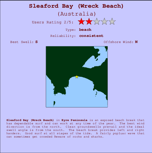
Sleaford Bay (Wreck Beach) Surf Guide
Sleaford Bay on the West Coast is an exposed beach break that usually has waves and can work at any time of the year. Offshore winds are from the north northeast. Most of the surf here comes from groundswells and the ideal swell direction is from the south. The beach breaks offer lefts and rights. Good surf at all stages of the tide. A fairly popluar wave that can sometimes get crowded Beware of rocks and sharks.
Sleaford Bay (Wreck Beach) Spot Info
| Type: | Rating: | Reliability: | Todays Sea Temp*: |
|---|---|---|---|
| consistent | 15.4°C*ocean temperature recorded from satellite |
Surfing Sleaford Bay (Wreck Beach):
The best conditions reported for surf at Sleaford Bay (Wreck Beach) occur when a South swell combines with an offshore wind direction from the North.
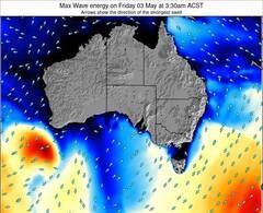
Previsioni Energia d'onda (Potenza): 12hrs

Sleaford Bay (Wreck Beach) Surf:
Friday, 17 July 2026, 15:16 Local time| Venerdì 17 | ||||
| 12:30PM | 3:30PM | 6:30PM | 9:30PM | |
| Wave (m) | ||||
| Periodo (s) | 16 | 16 | 15 | 15 |
| Vento (km/h) | ||||
| Stato del vento | cross- off |
cross- off |
cross- off |
cross- off |
- /breaks/Sleaford-Bay/forecasts/latest
Sleaford Bay (Wreck Beach) Surf Guide
Sleaford Bay on the West Coast is an exposed beach break that usually has waves and can work at any time of the year. Offshore winds are from the north northeast. Most of the surf here comes from groundswells and the ideal swell direction is from the south. The beach breaks offer lefts and rights. Good surf at all stages of the tide. A fairly popluar wave that can sometimes get crowded Beware of rocks and sharks.
Sleaford Bay (Wreck Beach) Spot Info
Type: Rating: Reliability: Todays Sea Temp*:  Beach
Beach 2
2consistent 15.4°C*ocean temperature recorded from satelliteSurfing Sleaford Bay (Wreck Beach):
The best conditions reported for surf at Sleaford Bay (Wreck Beach) occur when a South swell combines with an offshore wind direction from the North.
Previsioni Energia d'onda (Potenza): 12hrs
Utilizzare la scheda di navigazione in alto per visualizzare Sleaford Bay (Wreck Beach) temperatura del mare, Sleaford Bay (Wreck Beach) fotografie, Sleaford Bay (Wreck Beach) dettagliate previsioni onde, il vento e le previsioni meteo, Sleaford Bay (Wreck Beach) webcam, vento corrente da SA - Eyre Peninsula stazioni meteo e Sleaford Bay (Wreck Beach) previsioni marea. Il link Australia mappe maree apre l'immagine grande, che mostra Australia e dei mari circostanti. Queste mappe possono essere animate per mostrare le diverse componenti del moto ondoso, energia delle onde, periodo d'onda, altezza delle onde, insieme con le previsioni del vento e meteo, meteo corrente e osservazioni sullo stato del mare dal Australia onda-boe, le navi passanti e stazioni meteo costiere. Ciascuna delle pagine di previsioni per questo surf break rappresenta uno strumento di wavefinder globale e regionale per individuare le migliori condizioni di surf nella zona intorno Sleaford Bay (Wreck Beach).
Sleaford Bay (Wreck Beach) Surf:
Friday, 17 July 2026, 15:16 Local timeVenerdì 17 12:30PM 3:30PM 6:30PM 9:30PM Wave (m) Periodo (s) 16 16 15 15 Vento (km/h) Stato del vento cross-
offcross-
offcross-
offcross-
off- /breaks/Sleaford-Bay/forecasts/latest
- /breaks/Sleaford-Bay/forecasts/latest/six_day
Sleaford Bay (Wreck Beach) Surf Guide
Sleaford Bay on the West Coast is an exposed beach break that usually has waves and can work at any time of the year. Offshore winds are from the north northeast. Most of the surf here comes from groundswells and the ideal swell direction is from the south. The beach breaks offer lefts and rights. Good surf at all stages of the tide. A fairly popluar wave that can sometimes get crowded Beware of rocks and sharks.
Sleaford Bay (Wreck Beach) Spot Info
Type: Rating: Reliability: Todays Sea Temp*: Beach2consistent 15.4°C*ocean temperature recorded from satelliteSurfing Sleaford Bay (Wreck Beach):
The best conditions reported for surf at Sleaford Bay (Wreck Beach) occur when a South swell combines with an offshore wind direction from the North.
Previsioni Energia d'onda (Potenza): 12hrs
Utilizzare la scheda di navigazione in alto per visualizzare Sleaford Bay (Wreck Beach) temperatura del mare, Sleaford Bay (Wreck Beach) fotografie, Sleaford Bay (Wreck Beach) dettagliate previsioni onde, il vento e le previsioni meteo, Sleaford Bay (Wreck Beach) webcam, vento corrente da SA - Eyre Peninsula stazioni meteo e Sleaford Bay (Wreck Beach) previsioni marea. Il link Australia mappe maree apre l'immagine grande, che mostra Australia e dei mari circostanti. Queste mappe possono essere animate per mostrare le diverse componenti del moto ondoso, energia delle onde, periodo d'onda, altezza delle onde, insieme con le previsioni del vento e meteo, meteo corrente e osservazioni sullo stato del mare dal Australia onda-boe, le navi passanti e stazioni meteo costiere. Ciascuna delle pagine di previsioni per questo surf break rappresenta uno strumento di wavefinder globale e regionale per individuare le migliori condizioni di surf nella zona intorno Sleaford Bay (Wreck Beach).
Sleaford Bay (Wreck Beach) Surf:
Friday, 17 July 2026, 15:16 Local timeVenerdì 17 12:30PM 3:30PM 6:30PM 9:30PM Wave (m) Periodo (s) 16 16 15 15 Vento (km/h) Stato del vento cross-
offcross-
offcross-
offcross-
off- /breaks/Sleaford-Bay/forecasts/latest
Sleaford Bay (Wreck Beach) Surf Guide
Sleaford Bay on the West Coast is an exposed beach break that usually has waves and can work at any time of the year. Offshore winds are from the north northeast. Most of the surf here comes from groundswells and the ideal swell direction is from the south. The beach breaks offer lefts and rights. Good surf at all stages of the tide. A fairly popluar wave that can sometimes get crowded Beware of rocks and sharks.
Sleaford Bay (Wreck Beach) Spot Info
Type: Rating: Reliability: Todays Sea Temp*: Beach2consistent 15.4°C*ocean temperature recorded from satelliteSurfing Sleaford Bay (Wreck Beach):
The best conditions reported for surf at Sleaford Bay (Wreck Beach) occur when a South swell combines with an offshore wind direction from the North.
Previsioni Energia d'onda (Potenza): 12hrs
Utilizzare la scheda di navigazione in alto per visualizzare Sleaford Bay (Wreck Beach) temperatura del mare, Sleaford Bay (Wreck Beach) fotografie, Sleaford Bay (Wreck Beach) dettagliate previsioni onde, il vento e le previsioni meteo, Sleaford Bay (Wreck Beach) webcam, vento corrente da SA - Eyre Peninsula stazioni meteo e Sleaford Bay (Wreck Beach) previsioni marea. Il link Australia mappe maree apre l'immagine grande, che mostra Australia e dei mari circostanti. Queste mappe possono essere animate per mostrare le diverse componenti del moto ondoso, energia delle onde, periodo d'onda, altezza delle onde, insieme con le previsioni del vento e meteo, meteo corrente e osservazioni sullo stato del mare dal Australia onda-boe, le navi passanti e stazioni meteo costiere. Ciascuna delle pagine di previsioni per questo surf break rappresenta uno strumento di wavefinder globale e regionale per individuare le migliori condizioni di surf nella zona intorno Sleaford Bay (Wreck Beach).
Sleaford Bay (Wreck Beach) Surf:
Friday, 17 July 2026, 15:16 Local timeVenerdì 17 12:30PM 3:30PM 6:30PM 9:30PM Wave (m) Periodo (s) 16 16 15 15 Vento (km/h) Stato del vento cross-
offcross-
offcross-
offcross-
offTide Times:
Per Fishery Bay, %{dist} %{km} da %{location}.
PROSSIMA È ALLE (ora locale) rimanente alta marea bassa marea Sleaford Bay (Wreck Beach) Tide Times and Tide Chart
Live Weather:
At Port Lincoln, 31 km from Sleaford Bay (Wreck Beach).
wind obs. (7 kph from 200 degs) was rejected
(km/h)
no reportAir temperature
12.5°COverall Sleaford Bay (Wreck Beach) Surf Consistency and Wind Distribution in Luglio


Wind stats for Sleaford Bay (Wreck Beach): see the variation in direction and stength by month.
foto dall' album
Contorni: Strade e fiumi: seleziona un surf break dal menu 


Utilizzare questa mappa sollievo per navigare SA - Eyre Peninsula surf breaks e stazioni di marea che si trovano nella zona diSleaford Bay (Wreck Beach)
Altri surf breaks più vicini al Sleaford Bay (Wreck Beach):
(clicca sul nome del luogo per maggiori informazioni)- Closest località surf6 mi
- Second closest località surf21 mi
- Third closest località surf27 mi
- Fourth closest località surf42 mi
- Fifth closest località surf42 mi
Onda boe più vicina a Sleaford Bay (Wreck Beach):
- Closest Onda boa97 mi
- Second closest Onda boa709 mi
- Third closest Onda boa823 mi
- Fourth closest Onda boa825 mi
- Fifth closest Onda boa868 mi
Stazioni di marea più vicina alla Sleaford Bay (Wreck Beach):
- Closest marea stazioneTaylors Landing11 mi
- Second closest marea stazionePort Lincoln12 mi
- Third closest marea stazioneThistle Island34 mi
- Fourth closest marea stazioneWedge Island50 mi
- Fifth closest marea stazioneGreenly Island57 mi
Airports
- The nearest passenger airport to Sleaford Bay is Adelaide International Airport (ADL) in Australia, which is 258 km (160 miles) away (directly).
- The second closest airport to Sleaford Bay is Woomera Airport (UMR), also in Australia, 432 km (268 miles) away.
- /breaks/Sleaford-Bay/forecasts/latest


 Nearest