
Previsioni:

Previsione a breve terminePioggia moderata (Totale 18mm), più pesante Lunedì mattina. Warm (Max 25°C Sabato pomeriggio, Min 21°C Lunedì mattina). Venti decrescenti (venti freschi da ENE Venerdì notte, calma per lunedì mattina). | ||||||||||||||||||
Ven 17 | Sabato 18 | Domenica 19 | ||||||||||||||||
8 PM | 11 PM | 2 AM | 5 AM | 8 AM | 11 AM | 2 PM | 5 PM | 8 PM | 11 PM | 2 AM | 5 AM | 8 AM | 11 AM | 2 PM | 5 PM | 8 PM | 11 PM | |
Mappa dell'altezza del moto ondoso |  | 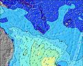 | 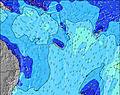 | 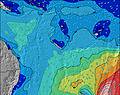 | 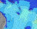 | 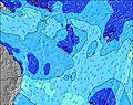 | 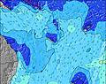 | |||||||||||
Onda Altezza (m) Direzione Periodo (s) | E 9 | E 9 | E 9 | E 9 | E 9 | ESE 9 | ESE 9 | E 9 | ESE 9 | ESE 9 | ESE 9 | ESE 9 | ESE 9 | ESE 9 | ESE 9 | ESE 9 | ESE 9 | S 22 |
Grafico delle onde | ||||||||||||||||||
951 | 1158 | 1159 | 1098 | 1212 | 398 | 398 | 937 | 292 | 237 | 286 | 292 | 340 | 292 | 292 | 292 | 237 | 242 | |
Vento (km/h) | ||||||||||||||||||
Stato del vento onshore cross-onshore cross-shore cross-offshore offshore piatto | cross | cross | cross | cross | cross | cross | cross | cross | cross | cross | cross | cross | cross | cross | cross | cross-off | cross-off | cross-off |
Alta Marea | 8:14PM1.26m | 7:45AM1.25m | 9:00PM1.25m | 8:42AM1.14m | 9:46PM1.24m | |||||||||||||
Basso Marea | 1:57AM0.49m | 2:19PM0.14m | 2:55AM0.49m | 3:04PM0.27m | ||||||||||||||
— | — | — | 6:16 | — | — | — | — | — | — | — | 6:16 | — | — | — | — | — | — | |
— | — | — | — | — | — | — | 5:27 | — | — | — | — | — | — | — | 5:27 | — | — | |
mm | 1 | 1 | — | — | — | — | — | — | — | — | — | — | — | — | — | — | — | — |
Temp. °C | 24 | 23 | 24 | 24 | 24 | 24 | 25 | 24 | 24 | 24 | 24 | 24 | 24 | 25 | 25 | 24 | 24 | 24 |
Gelo °C | 22 | 20 | 22 | 22 | 22 | 22 | 24 | 23 | 23 | 23 | 23 | 23 | 23 | 23 | 24 | 23 | 23 | 24 |
Onda 1 Altezza (m) Direzione Periodo (s) | SSW 17 | SSW 17 | SSW 16 | SE 20 | SE 19 | ESE 9 | ESE 9 | SE 18 | ESE 9 | ESE 9 | ESE 9 | ESE 9 | ESE 9 | ESE 9 | ESE 9 | ESE 9 | ESE 9 | ESE 9 |
28 | 28 | 25 | 60 | 95 | 398 | 398 | 194 | 292 | 237 | 286 | 292 | 340 | 292 | 292 | 292 | 237 | 237 | |
Onda 2 Altezza (m) Direzione Periodo (s) | SE 22 | SE 21 | SE 21 | SSW 16 | SW 12 | SE 19 | SE 18 | SSW 19 | SE 17 | SE 17 | SE 16 | SE 16 | SE 16 | SE 16 | SE 15 | SE 15 | SE 15 | SE 15 |
18 | 18 | 17 | 24 | 6 | 127 | 159 | 69 | 188 | 177 | 167 | 251 | 245 | 239 | 229 | 224 | 218 | 215 | |
Onda 3 Altezza (m) Direzione Periodo (s) | E 21 | — | E 15 | — | S 16 | SSW 19 | S 19 | W 11 | SSW 18 | SSW 18 | SSW 18 | SSW 17 | SSW 17 | SSW 16 | SSW 16 | SSW 23 | SSW 23 | S 22 |
9 | — | 4 | — | 5 | 37 | 29 | 2 | 66 | 64 | 103 | 100 | 92 | 84 | 47 | 107 | 172 | 242 | |
onde vento Altezza (m) Direzione Periodo (s) | E 9 | E 9 | E 9 | E 9 | E 9 | ENE 10 | ENE 9 | E 9 | ENE 9 | ENE 9 | ENE 10 | ENE 10 | ENE 9 | ENE 9 | ENE 9 | ENE 9 | ENE 9 | ENE 9 |
951 | 1158 | 1159 | 1098 | 1212 | 846 | 695 | 937 | 585 | 645 | 688 | 688 | 528 | 528 | 528 | 485 | 539 | 606 | |
Il più vicino Offshore or Glassy | ||||||||||||||||||
Distanza (km) | 527 | 527 | 527 | 527 | 527 | 527 | 527 | 527 | 23 | 23 | 23 | 23 | 527 | 527 | 527 | 23 | 23 | 13 |
Migliori previsioni per le condizioni d'onda in Efate | ||||||||||||||||||
Migliori previsioni per le condizioni d'onda in Vanuatu | ||||||||||||||||||
Trova Onde Globale | ||||||||||||||||||
- Map Icons:
 Break
Break Live Wave Height (m)
 Live Wind Speed (km/h)
 Surf Rating (10 Max)
 Ocean Swells (m)
- Wind Speed (km/h)
Widget Free Surf-Forecast.com per il tuo sito
La relazione di surf / widget meteo è disponibile qui sotto per incorporare su siti esterni a titolo gratuito e fornisce una sintesi delle nostre Soumabal Point previsione surf. Basta prendere il frammento di codice html da noi fornito e copiarlo nel proprio sito. È possibile scegliere la lingua preferita e unità metriche / imperiali per il feed delle previsioni surf per soddisfare le esigenze degli utenti del vostro sito .... Clicca qui per ottenere il codice.
 Nearest