
Previsioni:

Previsione a breve terminepioggia leggera (Totale 8mm), per lo più che cade martedì mattina. Very mild (Max 13°C mercoledì pomeriggio, Min 7°C mercoledì notte). Vento sarà generalmente leggero. | ||||||||||||||||||
Lun 3 | Martedì 4 | Mercoledì 5 | ||||||||||||||||
7 PM | 10 PM | 1 AM | 4 AM | 7 AM | 10 AM | 1 PM | 4 PM | 7 PM | 10 PM | 1 AM | 4 AM | 7 AM | 10 AM | 1 PM | 4 PM | 7 PM | 10 PM | |
Mappa dell'altezza del moto ondoso |  |  |  |  |  | 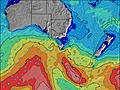 |  | |||||||||||
Onda Altezza (m) Direzione Periodo (s) | WSW 14 | WSW 13 | WSW 13 | WSW 12 | SW 12 | WSW 12 | SW 12 | SW 11 | SW 10 | SW 10 | SW 11 | SW 11 | SW 9 | SW 14 | SW 14 | SW 14 | SW 13 | SW 13 |
Grafico delle onde | ||||||||||||||||||
2721 | 4295 | 2402 | 3017 | 1348 | 3050 | 1715 | 1625 | 1309 | 815 | 745 | 283 | 376 | 965 | 1092 | 1033 | 1014 | 755 | |
Vento (km/h) | ||||||||||||||||||
Stato del vento onshore cross-onshore cross-shore cross-offshore offshore piatto | off | off | off | off | off | off | cross-off | cross-off | cross-off | cross-off | cross-off | cross-off | cross-off | cross-off | cross-off | cross-off | off | off |
Alta Marea | 3:12AM1.77m | 3:22PM1.89m | 3:53AM1.83m | 3:50PM1.86m | ||||||||||||||
Basso Marea | 9:09PM0.41m | 9:13AM0.43m | 9:39PM0.31m | 9:51AM0.50m | ||||||||||||||
— | — | — | — | 7:22 | — | — | — | — | — | — | — | 7:22 | — | — | — | — | — | |
— | — | — | — | — | — | — | 5:37 | — | — | — | — | — | — | — | 5:37 | — | — | |
mm | — | 1 | 1 | — | — | 2 | 1 | 1 | — | — | — | — | 1 | — | 1 | — | — | — |
Temp. °C | 10 | 10 | 9 | 8 | 8 | 10 | 12 | 12 | 11 | 11 | 10 | 10 | 10 | 11 | 12 | 13 | 10 | 10 |
Gelo °C | 6 | 7 | 4 | 4 | 4 | 6 | 8 | 8 | 8 | 8 | 7 | 7 | 7 | 8 | 8 | 9 | 7 | 8 |
Onda 1 Altezza (m) Direzione Periodo (s) | SW 14 | SW 13 | SW 13 | SW 11 | SW 12 | SW 12 | SW 16 | SW 16 | SW 10 | SW 10 | SW 11 | SW 9 | SW 9 | SW 14 | SW 14 | SW 14 | SW 13 | SW 13 |
1950 | 1736 | 1817 | 698 | 1348 | 1546 | 93 | 248 | 1086 | 815 | 745 | 281 | 249 | 965 | 1092 | 1033 | 778 | 755 | |
Onda 2 Altezza (m) Direzione Periodo (s) | S 13 | SW 18 | SW 18 | SW 13 | SW 17 | SW 16 | — | S 16 | SW 15 | SW 14 | SW 15 | SW 11 | SW 11 | SW 19 | SW 19 | SW 19 | SW 18 | SW 18 |
3 | 194 | 300 | 791 | 173 | 208 | — | 5 | 215 | 203 | 137 | 283 | 268 | 365 | 296 | 287 | 314 | 307 | |
Onda 3 Altezza (m) Direzione Periodo (s) | — | S 18 | S 18 | SW 18 | SW 16 | — | — | — | SW 21 | SW 21 | SW 21 | SW 20 | SW 20 | — | S 9 | — | — | S 17 |
— | 6 | 6 | 192 | 219 | — | — | — | 72 | 154 | 208 | 248 | 373 | — | 7 | — | — | 6 | |
onde vento Altezza (m) Direzione Periodo (s) | WSW 14 | WSW 13 | WSW 13 | WSW 12 | NW 3 | WSW 12 | SW 12 | SW 11 | SW 10 | — | — | — | SW 9 | — | — | — | SW 13 | — |
2721 | 4295 | 2402 | 3017 | 2 | 3050 | 1715 | 1625 | 1309 | — | — | — | 376 | — | — | — | 1014 | — | |
Il più vicino Offshore or Glassy | ||||||||||||||||||
Distanza (km) | 0 | 0 | 0 | 0 | 0 | 0 | 23 | 23 | 0 | 0 | 0 | 0 | 0 | 0 | 23 | 1 | 0 | 0 |
Migliori previsioni per le condizioni d'onda in Cape Otway | ||||||||||||||||||
Migliori previsioni per le condizioni d'onda in Australia | ||||||||||||||||||
Trova Onde Globale | ||||||||||||||||||
- Map Icons:
 Break
Break Live Wave Height (m)
 Live Wind Speed (km/h)
 Surf Rating (10 Max)
 Ocean Swells (m)
- Wind Speed (km/h)
Widget Free Surf-Forecast.com per il tuo sito
La relazione di surf / widget meteo è disponibile qui sotto per incorporare su siti esterni a titolo gratuito e fornisce una sintesi delle nostre St George River previsione surf. Basta prendere il frammento di codice html da noi fornito e copiarlo nel proprio sito. È possibile scegliere la lingua preferita e unità metriche / imperiali per il feed delle previsioni surf per soddisfare le esigenze degli utenti del vostro sito .... Clicca qui per ottenere il codice.
 Nearest