
Previsioni:

Previsione a breve termineper lo più asciutto. Very mild (Max 18°C Sabato mattina, Min 10°C Sabato notte). Vento sarà generalmente leggero. | ||||||||||||||||||||||||
Sabato 25 | Domenica 26 | Lunedì 27 | ||||||||||||||||||||||
1 AM | 4 AM | 7 AM | 10 AM | 1 PM | 4 PM | 7 PM | 10 PM | 1 AM | 4 AM | 7 AM | 10 AM | 1 PM | 4 PM | 7 PM | 10 PM | 1 AM | 4 AM | 7 AM | 10 AM | 1 PM | 4 PM | 7 PM | 10 PM | |
Mappa dell'altezza del moto ondoso |  |  |  |  |  |  |  | 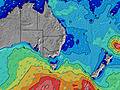 |  | |||||||||||||||
Onda Altezza (m) Direzione Periodo (s) | NE 8 | NE 9 | ENE 9 | ENE 9 | NE 9 | ENE 9 | ENE 9 | ENE 8 | ENE 8 | NE 8 | NE 8 | NE 8 | NE 8 | NE 8 | SE 14 | SE 14 | SE 13 | SE 13 | SE 13 | SE 14 | SE 15 | NE 3 | NNE 4 | NNE 4 |
Grafico delle onde | ||||||||||||||||||||||||
18 | 19 | 7 | 8 | 12 | 8 | 7 | 7 | 7 | 3 | 3 | 3 | 3 | 3 | 8 | 7 | 7 | 7 | 7 | 7 | 8 | 8 | 11 | 6 | |
Vento (km/h) | ||||||||||||||||||||||||
Stato del vento onshore cross-onshore cross-shore cross-offshore offshore piatto | cross-off | cross-off | off | off | glassy | cross-on | glassy | glassy | cross-off | off | off | off | glassy | on | glassy | cross-off | off | off | cross-off | cross-off | cross-on | cross-on | cross-off | cross-off |
Alta Marea | 5:08AM1.02m | 5:21PM1.60m | 6:06AM1.03m | 6:06PM1.65m | 6:55AM1.07m | 6:47PM1.69m | ||||||||||||||||||
Basso Marea | 11:36PM0.54m | 10:27AM0.59m | 00:25AM0.47m | 11:16AM0.59m | 1:08AM0.41m | 12:04PM0.58m | ||||||||||||||||||
— | 6:58 | — | — | — | — | — | — | — | 6:58 | — | — | — | — | — | — | — | 6:58 | — | — | — | — | — | — | |
— | — | — | — | — | 5:09 | — | — | — | — | — | — | — | 5:09 | — | — | — | — | — | — | — | 5:10 | — | — | |
mm | — | — | — | — | — | — | — | — | — | — | — | — | — | — | — | — | — | — | — | — | — | — | — | — |
Temp. °C | 8 | 9 | 10 | 14 | 18 | 17 | 16 | 13 | 12 | 10 | 11 | 12 | 15 | 15 | 14 | 13 | 12 | 11 | 11 | 14 | 17 | 17 | 16 | 13 |
Gelo °C | 4 | 5 | 5 | 10 | 16 | 14 | 15 | 11 | 9 | 7 | 8 | 10 | 13 | 12 | 13 | 11 | 10 | 8 | 8 | 12 | 13 | 12 | 13 | 9 |
Onda 1 Altezza (m) Direzione Periodo (s) | S 12 | S 11 | S 11 | S 10 | S 11 | S 11 | S 11 | S 11 | S 11 | S 11 | S 11 | S 10 | S 10 | S 10 | S 9 | S 9 | S 9 | S 8 | S 8 | S 8 | S 8 | S 8 | S 8 | S 8 |
1302 | 843 | 564 | 408 | 382 | 387 | 387 | 661 | 1107 | 1009 | 810 | 613 | 443 | 356 | 282 | 230 | 215 | 201 | 165 | 136 | 108 | 84 | 60 | 41 | |
Onda 2 Altezza (m) Direzione Periodo (s) | NE 8 | S 20 | ENE 9 | ENE 9 | NE 9 | ENE 9 | ENE 9 | ENE 8 | ENE 8 | NE 8 | NE 8 | NE 8 | NE 8 | NE 8 | NE 8 | NE 8 | NE 8 | NE 8 | NE 8 | SE 14 | SE 15 | SSE 8 | SSE 16 | NNE 4 |
18 | 8 | 7 | 8 | 12 | 8 | 7 | 7 | 7 | 3 | 3 | 3 | 3 | 3 | 3 | 2 | 2 | 3 | 3 | 7 | 8 | 6 | 25 | 6 | |
Onda 3 Altezza (m) Direzione Periodo (s) | — | — | S 20 | S 20 | S 20 | S 18 | — | — | — | — | — | — | — | S 15 | SE 14 | SE 14 | SE 13 | SE 13 | SE 13 | NE 8 | NE 8 | SE 14 | SSE 8 | SSE 16 |
— | — | 8 | 7 | 7 | 7 | — | — | — | — | — | — | — | 5 | 8 | 7 | 7 | 7 | 7 | 3 | 2 | 8 | 6 | 25 | |
onde vento Altezza (m) Direzione Periodo (s) | — | NE 9 | WNW 3 | W 3 | WNW 3 | — | — | S 11 | S 11 | — | — | — | — | — | — | — | — | — | — | — | — | NE 3 | NNE 4 | NW 3 |
— | 19 | 3 | 3 | 3 | — | — | 1018 | 1555 | — | — | — | — | — | — | — | — | — | — | — | — | 8 | 11 | 4 | |
Il più vicino Offshore or Glassy | ||||||||||||||||||||||||
Distanza (km) | 3 | 3 | 3 | 3 | 3 | 43 | 3 | 3 | 3 | 3 | 3 | 3 | 3 | 5 | 3 | 3 | 3 | 3 | 3 | 3 | 5 | 166 | 3 | 6 |
Migliori previsioni per le condizioni d'onda in South Coast - New South Wales | ||||||||||||||||||||||||
Migliori previsioni per le condizioni d'onda in Australia | ||||||||||||||||||||||||
Trova Onde Globale | ||||||||||||||||||||||||
- Map Icons:
 Break
Break Live Wave Height (m)
 Live Wind Speed (km/h)
 Surf Rating (10 Max)
 Ocean Swells (m)
- Wind Speed (km/h)
Widget Free Surf-Forecast.com per il tuo sito
La relazione di surf / widget meteo è disponibile qui sotto per incorporare su siti esterni a titolo gratuito e fornisce una sintesi delle nostre Dolphin Point previsione surf. Basta prendere il frammento di codice html da noi fornito e copiarlo nel proprio sito. È possibile scegliere la lingua preferita e unità metriche / imperiali per il feed delle previsioni surf per soddisfare le esigenze degli utenti del vostro sito .... Clicca qui per ottenere il codice.
 Nearest