

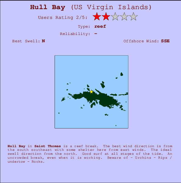
Hull Bay Surf Guide
Hull Bay in Saint Thomas is a quite exposed reef break. Offshore winds blow from the south southeast with some shelter here from east winds. The best swell direction is from the north. Surfable at all stages of the tide. Crowds are never a problem here. Take care of - Urchins - Rips / undertow - Rocks.
Hull Bay Spot Info
| Type: | Rating: | Reliability: | Todays Sea Temp*: |
|---|---|---|---|
28.6°C*ocean temperature recorded from satellite |
Surfing Hull Bay:
The best conditions reported for surf at Hull Bay occur when a North swell combines with an offshore wind direction from the South-southeast.

Previsioni Energia d'onda (Potenza): 12hrs


Hull Bay Surf:
Sunday, 19 July 2026, 19:29 Local time| Domenica 19 | Lun | |||
| 5PM | 8PM | 11PM | 2AM | |
| Wave (m) | ||||
| Periodo (s) | 7 | 9 | 9 | 9 |
| Vento (km/h) | ||||
| Stato del vento | cross- off |
cross | cross- off |
cross- off |
- /breaks/Hull-Bay/forecasts/latest
Hull Bay Surf Guide
Hull Bay in Saint Thomas is a quite exposed reef break. Offshore winds blow from the south southeast with some shelter here from east winds. The best swell direction is from the north. Surfable at all stages of the tide. Crowds are never a problem here. Take care of - Urchins - Rips / undertow - Rocks.
Hull Bay Spot Info
Type: Rating: Reliability: Todays Sea Temp*:  Reef
Reef 228.6°C*ocean temperature recorded from satellite
Surfing Hull Bay:
The best conditions reported for surf at Hull Bay occur when a North swell combines with an offshore wind direction from the South-southeast.
Previsioni Energia d'onda (Potenza): 12hrs
Utilizzare la scheda di navigazione in alto per visualizzare Hull Bay temperatura del mare, Hull Bay fotografie, Hull Bay dettagliate previsioni onde, il vento e le previsioni meteo, Hull Bay webcam, vento corrente da Saint Thomas stazioni meteo e Hull Bay previsioni marea. Il link US Virgin Islands mappe maree apre l'immagine grande, che mostra US Virgin Islands e dei mari circostanti. Queste mappe possono essere animate per mostrare le diverse componenti del moto ondoso, energia delle onde, periodo d'onda, altezza delle onde, insieme con le previsioni del vento e meteo, meteo corrente e osservazioni sullo stato del mare dal US Virgin Islands onda-boe, le navi passanti e stazioni meteo costiere. Ciascuna delle pagine di previsioni per questo surf break rappresenta uno strumento di wavefinder globale e regionale per individuare le migliori condizioni di surf nella zona intorno Hull Bay.
Hull Bay Surf:
Sunday, 19 July 2026, 19:29 Local timeDomenica 19 Lun 5PM 8PM 11PM 2AM Wave (m) Periodo (s) 7 9 9 9 Vento (km/h) Stato del vento cross-
offcross cross-
offcross-
off- /breaks/Hull-Bay/forecasts/latest
- /breaks/Hull-Bay/forecasts/latest/six_day
Hull Bay Surf Guide
Hull Bay in Saint Thomas is a quite exposed reef break. Offshore winds blow from the south southeast with some shelter here from east winds. The best swell direction is from the north. Surfable at all stages of the tide. Crowds are never a problem here. Take care of - Urchins - Rips / undertow - Rocks.
Hull Bay Spot Info
Type: Rating: Reliability: Todays Sea Temp*: Reef228.6°C*ocean temperature recorded from satelliteSurfing Hull Bay:
The best conditions reported for surf at Hull Bay occur when a North swell combines with an offshore wind direction from the South-southeast.
Previsioni Energia d'onda (Potenza): 12hrs
Utilizzare la scheda di navigazione in alto per visualizzare Hull Bay temperatura del mare, Hull Bay fotografie, Hull Bay dettagliate previsioni onde, il vento e le previsioni meteo, Hull Bay webcam, vento corrente da Saint Thomas stazioni meteo e Hull Bay previsioni marea. Il link US Virgin Islands mappe maree apre l'immagine grande, che mostra US Virgin Islands e dei mari circostanti. Queste mappe possono essere animate per mostrare le diverse componenti del moto ondoso, energia delle onde, periodo d'onda, altezza delle onde, insieme con le previsioni del vento e meteo, meteo corrente e osservazioni sullo stato del mare dal US Virgin Islands onda-boe, le navi passanti e stazioni meteo costiere. Ciascuna delle pagine di previsioni per questo surf break rappresenta uno strumento di wavefinder globale e regionale per individuare le migliori condizioni di surf nella zona intorno Hull Bay.
Hull Bay Surf:
Sunday, 19 July 2026, 19:29 Local timeDomenica 19 Lun 5PM 8PM 11PM 2AM Wave (m) Periodo (s) 7 9 9 9 Vento (km/h) Stato del vento cross-
offcross cross-
offcross-
off- /breaks/Hull-Bay/forecasts/latest
Hull Bay Surf Guide
Hull Bay in Saint Thomas is a quite exposed reef break. Offshore winds blow from the south southeast with some shelter here from east winds. The best swell direction is from the north. Surfable at all stages of the tide. Crowds are never a problem here. Take care of - Urchins - Rips / undertow - Rocks.
Hull Bay Spot Info
Type: Rating: Reliability: Todays Sea Temp*: Reef228.6°C*ocean temperature recorded from satelliteSurfing Hull Bay:
The best conditions reported for surf at Hull Bay occur when a North swell combines with an offshore wind direction from the South-southeast.
Previsioni Energia d'onda (Potenza): 12hrs
Utilizzare la scheda di navigazione in alto per visualizzare Hull Bay temperatura del mare, Hull Bay fotografie, Hull Bay dettagliate previsioni onde, il vento e le previsioni meteo, Hull Bay webcam, vento corrente da Saint Thomas stazioni meteo e Hull Bay previsioni marea. Il link US Virgin Islands mappe maree apre l'immagine grande, che mostra US Virgin Islands e dei mari circostanti. Queste mappe possono essere animate per mostrare le diverse componenti del moto ondoso, energia delle onde, periodo d'onda, altezza delle onde, insieme con le previsioni del vento e meteo, meteo corrente e osservazioni sullo stato del mare dal US Virgin Islands onda-boe, le navi passanti e stazioni meteo costiere. Ciascuna delle pagine di previsioni per questo surf break rappresenta uno strumento di wavefinder globale e regionale per individuare le migliori condizioni di surf nella zona intorno Hull Bay.
Hull Bay Surf:
Sunday, 19 July 2026, 19:29 Local timeDomenica 19 Lun 5PM 8PM 11PM 2AM Wave (m) Periodo (s) 7 9 9 9 Vento (km/h) Stato del vento cross-
offcross cross-
offcross-
offTide Times:
Per Magens Bay, Saint Thomas Island, Virgin Islands, %{dist} %{km} da %{location}.
PROSSIMA È ALLE (ora locale) rimanente alta marea bassa marea Hull Bay Tide Times and Tide Chart
Live Weather:
At St Thomas, 2 km from Hull Bay.
-
dryAir temperature
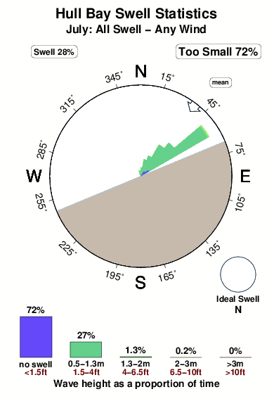
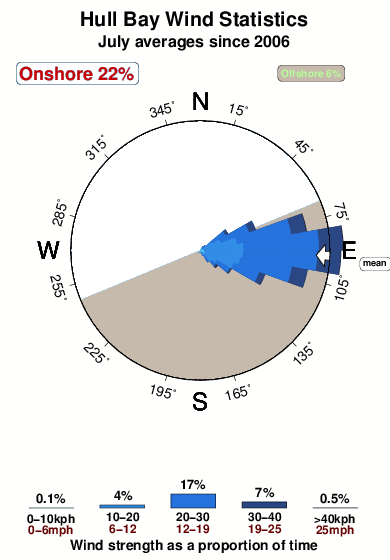
-°COverall Hull Bay Surf Consistency and Wind Distribution in Luglio
foto dall' album
Contorni: Strade e fiumi: seleziona un surf break dal menu 


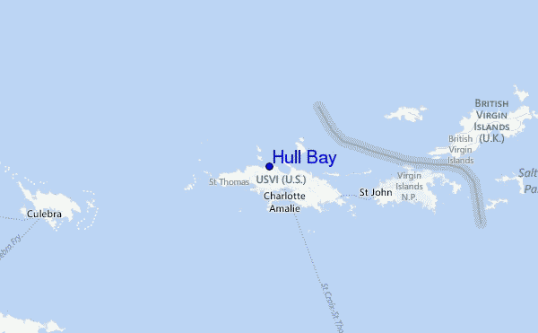
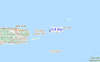
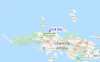
Utilizzare questa mappa sollievo per navigare Saint Thomas surf breaks e stazioni di marea che si trovano nella zona diHull Bay
Altri surf breaks più vicini al Hull Bay:
(clicca sul nome del luogo per maggiori informazioni)- Closest località surf2 mi
- Second closest località surf4 mi
- Third closest località surf5 mi
- Fourth closest località surf17 mi
- Fifth closest località surf17 mi
Onda boe più vicina a Hull Bay:
- Closest Onda boa16 mi
- Second closest Onda boa34 mi
- Third closest Onda boa75 mi
- Fourth closest Onda boa109 mi
- Fifth closest Onda boa152 mi
Stazioni di marea più vicina alla Hull Bay:
- Closest marea stazioneMagens Bay, Saint Thomas Island2 mi
- Second closest marea stazioneSaint Thomas, Saint Thomas3 mi
- Third closest marea stazioneCharlotte Amalie, Saint Thomas4 mi
- Fourth closest marea stazioneBenner Bay, Saint Thomas7 mi
- Fifth closest marea stazioneRedhook Bay, Saint Thomas Island8 mi
Airports
- The closest passenger airport to Hull Bay is Cyril E King (St. Thomas) Airport (STT) in Virgin Isl., 4 km (2 miles) away (directly).
- The second nearest airport to Hull Bay is Terrance B Lettsome International (Roadtown/beef Island) Airport (EIS), also in Virgin Isl., 44 km (27 miles) away.
- Third is Roosevelt Roads Ns Airport (NRR) in Puerto Rico, 74 km (46 miles) away.
- Diego Jimenez Torres (Fajardo) Airport (FAJ) in Puerto Rico is 75 km (47 miles) away.
- Henry E Rohlsen (St. Criox Island) Airport (STX) in Virgin Isl. is the fifth nearest airport to Hull Bay and is 76 km (47 miles) away.
- /breaks/Hull-Bay/forecasts/latest


 Nearest