
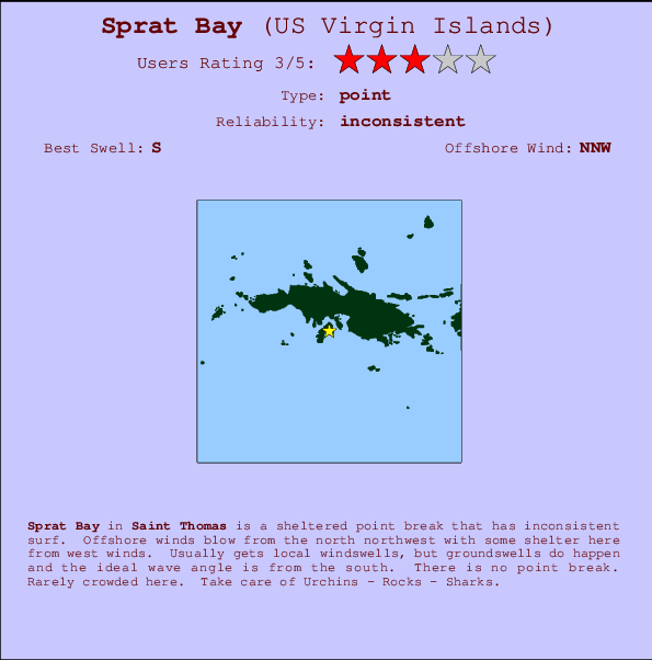
Sprat Bay Surf Guide
Sprat Bay in Saint Thomas is a sheltered point break that has unreliable waves. Offshore winds blow from the north northwest with some shelter here from west winds. Windswells are much more typical than groudswells and the ideal wave direction is from the south. There is no point break. It very rarely gets crowded here. Hazards include Urchins - Rocks - Sharks.
Sprat Bay Spot Info
| Type: | Rating: | Reliability: | Todays Sea Temp*: |
|---|---|---|---|
| inconsistent | 28.0°C*ocean temperature recorded from satellite |
Surfing Sprat Bay:
The best conditions reported for surf at Sprat Bay occur when a South swell combines with an offshore wind direction from the North-northwest.

Previsioni Energia d'onda (Potenza): 12hrs


Sprat Bay Surf:
Wednesday, 15 July 2026, 06:33 Local time| Mercoledì 15 | ||||
| 5AM | 8AM | 11AM | 2PM | |
| Wave (m) | ||||
| Periodo (s) | 6 | 6 | 6 | 6 |
| Vento (km/h) | ||||
| Stato del vento | cross- on |
cross- on |
cross- on |
cross- on |
- /breaks/Sprat-Bay/forecasts/latest
Sprat Bay Surf Guide
Sprat Bay in Saint Thomas is a sheltered point break that has unreliable waves. Offshore winds blow from the north northwest with some shelter here from west winds. Windswells are much more typical than groudswells and the ideal wave direction is from the south. There is no point break. It very rarely gets crowded here. Hazards include Urchins - Rocks - Sharks.
Sprat Bay Spot Info
Type: Rating: Reliability: Todays Sea Temp*:  Point
Point 3
3inconsistent 28.0°C*ocean temperature recorded from satelliteSurfing Sprat Bay:
The best conditions reported for surf at Sprat Bay occur when a South swell combines with an offshore wind direction from the North-northwest.
Previsioni Energia d'onda (Potenza): 12hrs
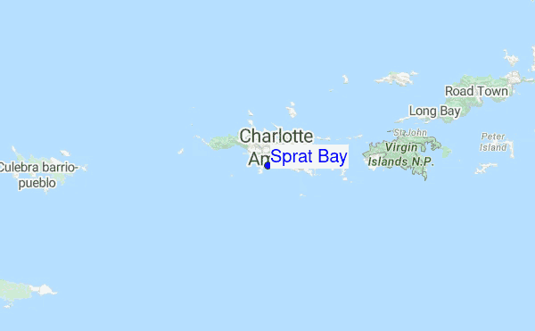
Utilizzare la scheda di navigazione in alto per visualizzare Sprat Bay temperatura del mare, Sprat Bay fotografie, Sprat Bay dettagliate previsioni onde, il vento e le previsioni meteo, Sprat Bay webcam, vento corrente da Saint Thomas stazioni meteo e Sprat Bay previsioni marea. Il link US Virgin Islands mappe maree apre l'immagine grande, che mostra US Virgin Islands e dei mari circostanti. Queste mappe possono essere animate per mostrare le diverse componenti del moto ondoso, energia delle onde, periodo d'onda, altezza delle onde, insieme con le previsioni del vento e meteo, meteo corrente e osservazioni sullo stato del mare dal US Virgin Islands onda-boe, le navi passanti e stazioni meteo costiere. Ciascuna delle pagine di previsioni per questo surf break rappresenta uno strumento di wavefinder globale e regionale per individuare le migliori condizioni di surf nella zona intorno Sprat Bay.
Sprat Bay Surf:
Wednesday, 15 July 2026, 06:33 Local timeMercoledì 15 5AM 8AM 11AM 2PM Wave (m) Periodo (s) 6 6 6 6 Vento (km/h) Stato del vento cross-
oncross-
oncross-
oncross-
on- /breaks/Sprat-Bay/forecasts/latest
- /breaks/Sprat-Bay/forecasts/latest/six_day
Sprat Bay Surf Guide
Sprat Bay in Saint Thomas is a sheltered point break that has unreliable waves. Offshore winds blow from the north northwest with some shelter here from west winds. Windswells are much more typical than groudswells and the ideal wave direction is from the south. There is no point break. It very rarely gets crowded here. Hazards include Urchins - Rocks - Sharks.
Sprat Bay Spot Info
Type: Rating: Reliability: Todays Sea Temp*: Point3inconsistent 28.0°C*ocean temperature recorded from satelliteSurfing Sprat Bay:
The best conditions reported for surf at Sprat Bay occur when a South swell combines with an offshore wind direction from the North-northwest.
Previsioni Energia d'onda (Potenza): 12hrs
Utilizzare la scheda di navigazione in alto per visualizzare Sprat Bay temperatura del mare, Sprat Bay fotografie, Sprat Bay dettagliate previsioni onde, il vento e le previsioni meteo, Sprat Bay webcam, vento corrente da Saint Thomas stazioni meteo e Sprat Bay previsioni marea. Il link US Virgin Islands mappe maree apre l'immagine grande, che mostra US Virgin Islands e dei mari circostanti. Queste mappe possono essere animate per mostrare le diverse componenti del moto ondoso, energia delle onde, periodo d'onda, altezza delle onde, insieme con le previsioni del vento e meteo, meteo corrente e osservazioni sullo stato del mare dal US Virgin Islands onda-boe, le navi passanti e stazioni meteo costiere. Ciascuna delle pagine di previsioni per questo surf break rappresenta uno strumento di wavefinder globale e regionale per individuare le migliori condizioni di surf nella zona intorno Sprat Bay.
Sprat Bay Surf:
Wednesday, 15 July 2026, 06:33 Local timeMercoledì 15 5AM 8AM 11AM 2PM Wave (m) Periodo (s) 6 6 6 6 Vento (km/h) Stato del vento cross-
oncross-
oncross-
oncross-
on- /breaks/Sprat-Bay/forecasts/latest
Sprat Bay Surf Guide
Sprat Bay in Saint Thomas is a sheltered point break that has unreliable waves. Offshore winds blow from the north northwest with some shelter here from west winds. Windswells are much more typical than groudswells and the ideal wave direction is from the south. There is no point break. It very rarely gets crowded here. Hazards include Urchins - Rocks - Sharks.
Sprat Bay Spot Info
Type: Rating: Reliability: Todays Sea Temp*: Point3inconsistent 28.0°C*ocean temperature recorded from satelliteSurfing Sprat Bay:
The best conditions reported for surf at Sprat Bay occur when a South swell combines with an offshore wind direction from the North-northwest.
Previsioni Energia d'onda (Potenza): 12hrs
Utilizzare la scheda di navigazione in alto per visualizzare Sprat Bay temperatura del mare, Sprat Bay fotografie, Sprat Bay dettagliate previsioni onde, il vento e le previsioni meteo, Sprat Bay webcam, vento corrente da Saint Thomas stazioni meteo e Sprat Bay previsioni marea. Il link US Virgin Islands mappe maree apre l'immagine grande, che mostra US Virgin Islands e dei mari circostanti. Queste mappe possono essere animate per mostrare le diverse componenti del moto ondoso, energia delle onde, periodo d'onda, altezza delle onde, insieme con le previsioni del vento e meteo, meteo corrente e osservazioni sullo stato del mare dal US Virgin Islands onda-boe, le navi passanti e stazioni meteo costiere. Ciascuna delle pagine di previsioni per questo surf break rappresenta uno strumento di wavefinder globale e regionale per individuare le migliori condizioni di surf nella zona intorno Sprat Bay.
Sprat Bay Surf:
Wednesday, 15 July 2026, 06:33 Local timeMercoledì 15 5AM 8AM 11AM 2PM Wave (m) Periodo (s) 6 6 6 6 Vento (km/h) Stato del vento cross-
oncross-
oncross-
oncross-
onTide Times:
Per Saint Thomas, Saint Thomas, %{dist} %{km} da %{location}.
PROSSIMA È ALLE (ora locale) rimanente alta marea bassa marea Sprat Bay Tide Times and Tide Chart
Live Weather:
At BUOY-CHAV3, 4 km from Sprat Bay.
light winds from the E
(km/h)Air temperature
27.3°Cfoto dall' album
Altri surf breaks più vicini al Sprat Bay:
(clicca sul nome del luogo per maggiori informazioni)- Closest località surf4 mi
- Second closest località surf4 mi
- Third closest località surf6 mi
- Fourth closest località surf17 mi
- Fifth closest località surf17 mi
Onda boe più vicina a Sprat Bay:
- Closest Onda boa13 mi
- Second closest Onda boa34 mi
- Third closest Onda boa76 mi
- Fourth closest Onda boa108 mi
- Fifth closest Onda boa154 mi
Stazioni di marea più vicina alla Sprat Bay:
- Closest marea stazioneSaint Thomas, Saint Thomas1 mi
- Second closest marea stazioneCharlotte Amalie, Saint Thomas2 mi
- Third closest marea stazioneMagens Bay, Saint Thomas Island4 mi
- Fourth closest marea stazioneBenner Bay, Saint Thomas5 mi
- Fifth closest marea stazioneRedhook Bay, Saint Thomas Island6 mi
- /breaks/Sprat-Bay/forecasts/latest

 Nearest