
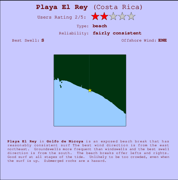
Playa El Rey Surf Guide
Playa El Rey in Golfo de Nicoya is an exposed beach break that has fairly consistent surf The best wind direction is from the east northeast. Groundswells are more common than windswells and the best swell direction is from the south. The beach break provides left and right handers. Surfable at all stages of the tide. It very rarely gets crowded here. Rocks are a hazard.
Playa El Rey Spot Info
| Type: | Rating: | Reliability: | Todays Sea Temp*: |
|---|---|---|---|
| fairly consistent | 30.1°C*ocean temperature recorded from satellite |
Surfing Playa El Rey:
The best conditions reported for surf at Playa El Rey occur when a South swell combines with an offshore wind direction from the East-northeast.

Previsioni Energia d'onda (Potenza): 12hrs


Playa El Rey Surf:
Sunday, 19 July 2026, 02:24 Local time| Domenica 19 | ||||
| 3AM | 6AM | 9AM | 12PM | |
| Wave (m) | ||||
| Periodo (s) | 13 | 14 | 12 | 12 |
| Vento (km/h) | ||||
| Stato del vento | glass | cross- off |
glass | on |
- /breaks/Playa-El-Rey/forecasts/latest
Playa El Rey Surf Guide
Playa El Rey in Golfo de Nicoya is an exposed beach break that has fairly consistent surf The best wind direction is from the east northeast. Groundswells are more common than windswells and the best swell direction is from the south. The beach break provides left and right handers. Surfable at all stages of the tide. It very rarely gets crowded here. Rocks are a hazard.
Playa El Rey Spot Info
Type: Rating: Reliability: Todays Sea Temp*:  Beach
Beach 2
2fairly consistent 30.1°C*ocean temperature recorded from satelliteSurfing Playa El Rey:
The best conditions reported for surf at Playa El Rey occur when a South swell combines with an offshore wind direction from the East-northeast.
Previsioni Energia d'onda (Potenza): 12hrs
Utilizzare la scheda di navigazione in alto per visualizzare Playa El Rey temperatura del mare, Playa El Rey fotografie, Playa El Rey dettagliate previsioni onde, il vento e le previsioni meteo, Playa El Rey webcam, vento corrente da Golfo de Nicoya stazioni meteo e Playa El Rey previsioni marea. Il link Costa Rica mappe maree apre l'immagine grande, che mostra Costa Rica e dei mari circostanti. Queste mappe possono essere animate per mostrare le diverse componenti del moto ondoso, energia delle onde, periodo d'onda, altezza delle onde, insieme con le previsioni del vento e meteo, meteo corrente e osservazioni sullo stato del mare dal Costa Rica onda-boe, le navi passanti e stazioni meteo costiere. Ciascuna delle pagine di previsioni per questo surf break rappresenta uno strumento di wavefinder globale e regionale per individuare le migliori condizioni di surf nella zona intorno Playa El Rey.
Playa El Rey Surf:
Sunday, 19 July 2026, 02:24 Local timeDomenica 19 3AM 6AM 9AM 12PM Wave (m) Periodo (s) 13 14 12 12 Vento (km/h) Stato del vento glass cross-
offglass on - /breaks/Playa-El-Rey/forecasts/latest
- /breaks/Playa-El-Rey/forecasts/latest/six_day
Playa El Rey Surf Guide
Playa El Rey in Golfo de Nicoya is an exposed beach break that has fairly consistent surf The best wind direction is from the east northeast. Groundswells are more common than windswells and the best swell direction is from the south. The beach break provides left and right handers. Surfable at all stages of the tide. It very rarely gets crowded here. Rocks are a hazard.
Playa El Rey Spot Info
Type: Rating: Reliability: Todays Sea Temp*: Beach2fairly consistent 30.1°C*ocean temperature recorded from satelliteSurfing Playa El Rey:
The best conditions reported for surf at Playa El Rey occur when a South swell combines with an offshore wind direction from the East-northeast.
Previsioni Energia d'onda (Potenza): 12hrs
Utilizzare la scheda di navigazione in alto per visualizzare Playa El Rey temperatura del mare, Playa El Rey fotografie, Playa El Rey dettagliate previsioni onde, il vento e le previsioni meteo, Playa El Rey webcam, vento corrente da Golfo de Nicoya stazioni meteo e Playa El Rey previsioni marea. Il link Costa Rica mappe maree apre l'immagine grande, che mostra Costa Rica e dei mari circostanti. Queste mappe possono essere animate per mostrare le diverse componenti del moto ondoso, energia delle onde, periodo d'onda, altezza delle onde, insieme con le previsioni del vento e meteo, meteo corrente e osservazioni sullo stato del mare dal Costa Rica onda-boe, le navi passanti e stazioni meteo costiere. Ciascuna delle pagine di previsioni per questo surf break rappresenta uno strumento di wavefinder globale e regionale per individuare le migliori condizioni di surf nella zona intorno Playa El Rey.
Playa El Rey Surf:
Sunday, 19 July 2026, 02:24 Local timeDomenica 19 3AM 6AM 9AM 12PM Wave (m) Periodo (s) 13 14 12 12 Vento (km/h) Stato del vento glass cross-
offglass on - /breaks/Playa-El-Rey/forecasts/latest
Playa El Rey Surf Guide
Playa El Rey in Golfo de Nicoya is an exposed beach break that has fairly consistent surf The best wind direction is from the east northeast. Groundswells are more common than windswells and the best swell direction is from the south. The beach break provides left and right handers. Surfable at all stages of the tide. It very rarely gets crowded here. Rocks are a hazard.
Playa El Rey Spot Info
Type: Rating: Reliability: Todays Sea Temp*: Beach2fairly consistent 30.1°C*ocean temperature recorded from satelliteSurfing Playa El Rey:
The best conditions reported for surf at Playa El Rey occur when a South swell combines with an offshore wind direction from the East-northeast.
Previsioni Energia d'onda (Potenza): 12hrs
Utilizzare la scheda di navigazione in alto per visualizzare Playa El Rey temperatura del mare, Playa El Rey fotografie, Playa El Rey dettagliate previsioni onde, il vento e le previsioni meteo, Playa El Rey webcam, vento corrente da Golfo de Nicoya stazioni meteo e Playa El Rey previsioni marea. Il link Costa Rica mappe maree apre l'immagine grande, che mostra Costa Rica e dei mari circostanti. Queste mappe possono essere animate per mostrare le diverse componenti del moto ondoso, energia delle onde, periodo d'onda, altezza delle onde, insieme con le previsioni del vento e meteo, meteo corrente e osservazioni sullo stato del mare dal Costa Rica onda-boe, le navi passanti e stazioni meteo costiere. Ciascuna delle pagine di previsioni per questo surf break rappresenta uno strumento di wavefinder globale e regionale per individuare le migliori condizioni di surf nella zona intorno Playa El Rey.
Playa El Rey Surf:
Sunday, 19 July 2026, 02:24 Local timeDomenica 19 3AM 6AM 9AM 12PM Wave (m) Periodo (s) 13 14 12 12 Vento (km/h) Stato del vento glass cross-
offglass on Tide Times:
A Playa El Rey (0 km).
PROSSIMA È ALLE (ora locale) rimanente alta marea bassa marea Playa El Rey Tide Times and Tide Chart
Live Weather:
At San Jose, 67 km from Playa El Rey.
calm
(km/h)
dryAir temperature
21°COverall Playa El Rey Surf Consistency and Wind Distribution in Luglio


Wind stats for Playa El Rey: see the variation in direction and stength by month.
foto dall' album
Contorni: Strade e fiumi: seleziona un surf break dal menu 


Utilizzare questa mappa sollievo per navigare Golfo de Nicoya surf breaks e stazioni di marea che si trovano nella zona diPlaya El Rey
Altri surf breaks più vicini al Playa El Rey:
(clicca sul nome del luogo per maggiori informazioni)- Closest località surf11 mi
- Second closest località surf12 mi
- Third closest località surf13 mi
- Fourth closest località surf13 mi
- Fifth closest località surf17 mi
Onda boe più vicina a Playa El Rey:
- Closest Onda boa545 mi
- Second closest Onda boa732 mi
- Third closest Onda boa1102 mi
- Fourth closest Onda boa1132 mi
- Fifth closest Onda boa1155 mi
Stazioni di marea più vicina alla Playa El Rey:
- Closest marea stazioneChacarita70 mi
- Second closest marea stazionePunta Arenas72 mi
- Third closest marea stazioneGolfito75 mi
- Fourth closest marea stazioneLimon80 mi
- Fifth closest marea stazionePuerto Armuelles108 mi
Airports
- The closest passenger airport to Playa El Rey is Quepos Managua Airport (XQP) in Costa Rica, 19 km (12 miles) away (directly).
- The second nearest airport to Playa El Rey is Palmar Sur Airport (PMZ), also in Costa Rica, 72 km (45 miles) away.
- Third is Juan Santamaria International Airport (SJO) in Costa Rica, 77 km (48 miles) away.
- Golfito Airport (GLF) in Costa Rica is 117 km (73 miles) away.
- Limon International Airport (LIO), also in Costa Rica is the fifth nearest airport to Playa El Rey and is 128 km (80 miles) away.
- /breaks/Playa-El-Rey/forecasts/latest


 Nearest